
The Valley at a Glance
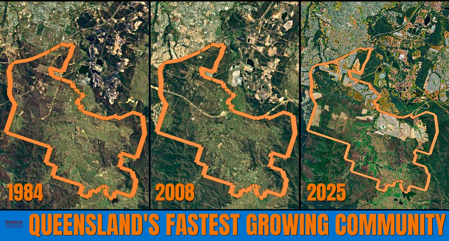
- Why here. In 2010, South East Queensland was projected to add 1.6 million people by 2031. The Queensland Government needed land to plan a whole new city. Ripley Valley fit: big single-owner paddocks and the new Centenary extension. So the state drew a line around 4,680 hectares and called it the Ripley Valley Priority Development Area.
- What the designation allows. Inside the PDA, applications get assessed under state planning rules. The Economic Development Act and the Ripley Valley Development Scheme. Not the Ipswich City Plan. Approvals get fast-tracked. The whole area gets planned as one big masterplan, not parcel by parcel.
- The scale. The Ripley Valley PDA is already home to 23,459 residents (June 2025) and was Queensland’s fastest-growing community in 2024-25, up 15.4% year over year.
- The setup. An urban core around Ripley Town Centre. A secondary centre directly west of it. Another secondary centre south-east across the Centenary at Providence. Smaller satellite villages filling the rest all the way south to Dalys Lagoon. Acreage and bushland around the edges.
🔢 By The Numbers
- 4,680 – hectares inside the growth boundary
- 2010 – the year the state declared the PDA
- 48,750 – homes planned at full buildout
- 131,000 – residents planned at full buildout
- 16,104 – residents already living in the valley (June 2025)
- 15.4% – population growth in 2024-25
- 3,131 – new residents added in 2024-25
- #1 – Queensland’s fastest-growing community in 2024-25
- $45 million – top recent land sale inside the boundary
- $30 million – a 3-block package currently for sale on Binnies Rd
- $7.9 million – paid for a 15 ha Ripley Rd frontage lot in June 2025
- March 2026 – Ripley Town Centre Stage 2 approved
Is there any rhyme or reason to the Ripley Valley Priority Development Area (PDA) boundary borders?
Why does it include most of South Ripley and Ripley, but only parts of White Rock, Flinders View and Deebing Heights?
Why not just lock in all of Ripley and South Ripley and call it a day?
In Part 1 of The Rise of Ripley you’ll see why. Why this valley. Why down to Dalys Lagoon. Why these exact lines.
Then in Parts 2 and 3 we’ll look at the masterplan, what’s built now, and what’s still to come.
Let’s jump in.
Jump to:
5 Things Every Ipswich Local Should Know About a Priority Development Area

- It’s a state-declared growth area. A Priority Development Area, or PDA, is an official growth area declared by the Queensland Government. Ripley Valley was declared on 8 October 2010.
- State rules, not council rules. Inside the PDA, applications get assessed under the Economic Development Act and the Ripley Valley Development Scheme. Not the Ipswich City Plan.
- Faster approvals. The PDA system fast-tracks development applications and lets the whole area be planned as one big masterplan, instead of parcel by parcel.
- Council still does the assessing. The state has delegated approval power for Ripley Valley back to Ipswich City Council. Same officers you’d deal with normally. They’re just applying state rules now.
- Ripley wasn’t a blank slate. Council had already started master planning Ripley Valley in 2006. The 2010 PDA declaration formalised that work and shifted legal power to the state.
Where Exactly is the Official Ripley Valley Growth Area?

Priority Development Area
The official growth area stretches far beyond Ripley Town Centre and Providence. In fact, it goes down to Dalys Lagoon at the bottom of South Ripley. On the south-western side, the PDA runs against the Flinders-Goolman Range.
The shape of it
- Hard boundaries. Cunningham Highway. White Rock – Spring Mountain Conservation Estate. The Centenary Motorway. The Flinders-Goolman Range. All work to form the boundary of the Ripley Valley growth area.
- 4,680 hectares. About 47 km2. For Ipswich scale, roughly 3x RAAF Amberley.
- Why this exact shape. Because this was one of the best-biggest-connected stretches of rural land left in the SEQ. Look at the hidden grid of land parcels in the QLD Globe image below. Huge blocks, not 1,000s of suburban lots. The masterplanned Ripley Valley neighbourhoods could become a reality without needing to negotiate 1,000s of residential real estate deals.
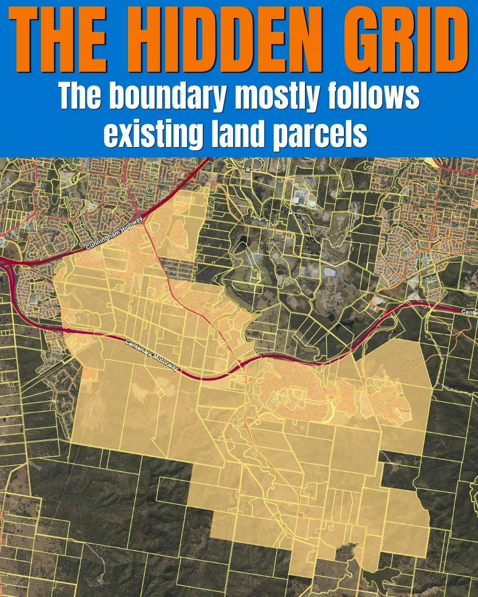
There’s the designated land parcels…
…But then there’s also the natural lay of the Ipswich land.
Topography of the Ripley Valley PDA
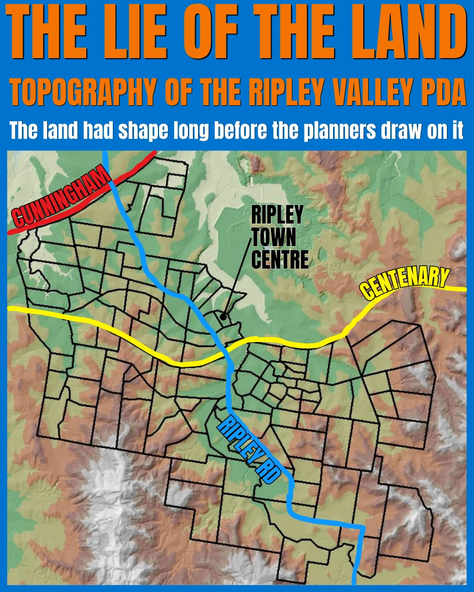
- The lie of the land. The place now marketed as Ripley Valley follows an older physical shape: the Bundamba Creek valley. White Rock-Spring Mountain rises along the eastern side, while the Flinders-Goolman Range frames the western and south-western side.
The Centenary Divide
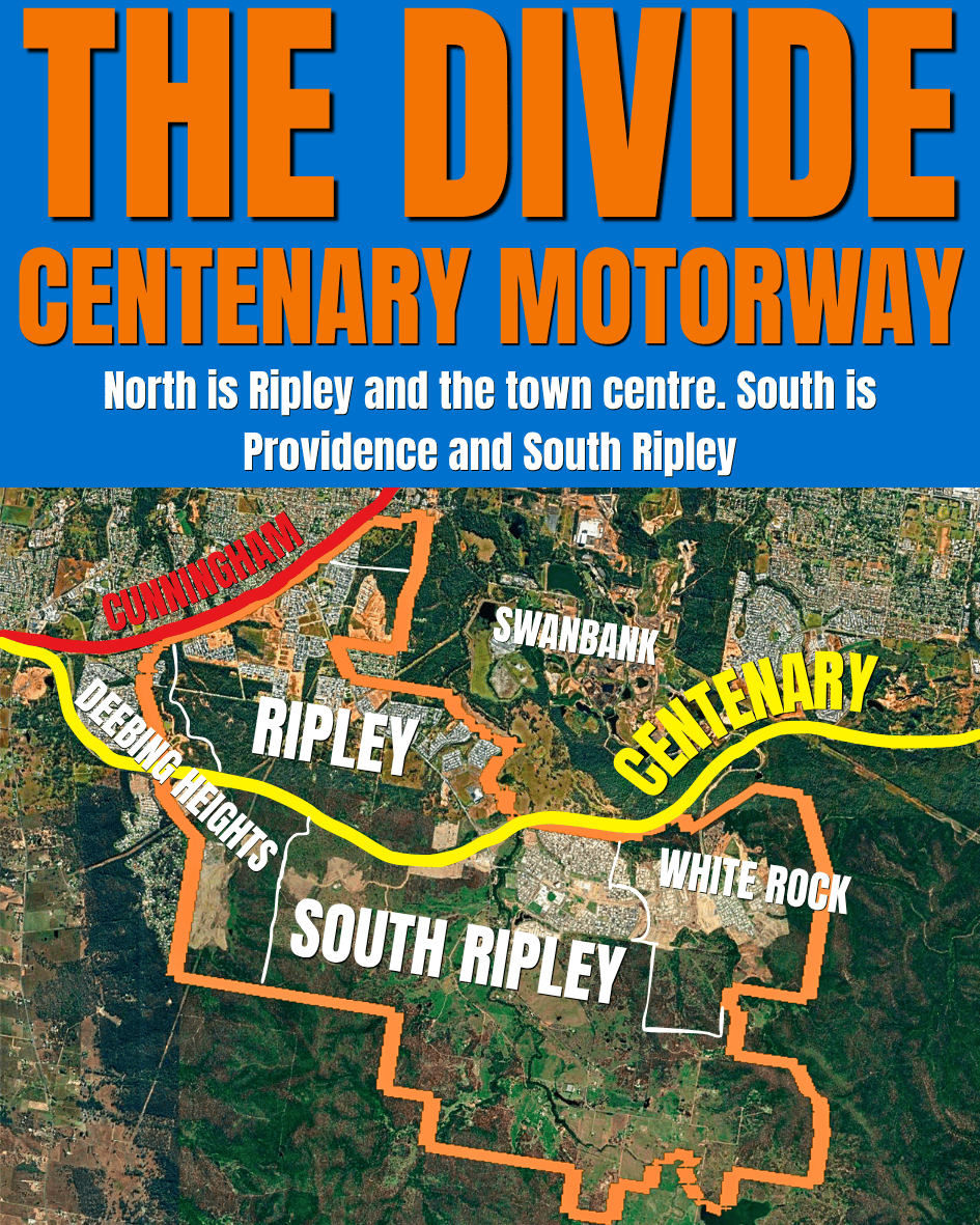
The Centenary Motorway Splits the Growth Area in Two
North of the motorway is Ripley and the town centre. South is Providence and South Ripley. The Centenary Motorway gives the PDA fast east-west access between Yamanto, Ripley and Springfield. But it also draws a hard line through the middle of the growth area.
Two halves, one valley
- Different speeds. Both sides have been developing for years, but they have grown in different ways. South Ripley is the side most locals now recognise through Providence, schools, parks and new rooftops. North of the motorway has Ecco Ripley and the town centre, which opened its first stage in 2018.
- Moving forward. The next wave is the town-centre core expanding, with Stage 2 now approved. It will add about 9,000m² of retail and lifestyle space. Basically 2x what’s there now.
⚠️ No active transport crossing

The Centenary Motorway gives drivers fast east-west access. But it makes north-south movement harder for people walking or riding.
As of May 2026, there is no designated active transport crossing. The two roundabouts at Ripley Road and Sandstone Boulevard / Wesley Way are the obvious places to plan future active transport crossings.
- Today: getting between the northern town-centre side and the southern Providence/South Ripley side is still awkward without a car.
- TMR has flagged it: the state’s Centenary Motorway planning includes active transport crossing planning between Yamanto and Ellen Grove.
- Funding listed: TMR’s project update says $1 million has been committed to planning potential active transport crossings at the Ripley Road / Centenary Motorway roundabout.
The Northern Buildout Still To Come
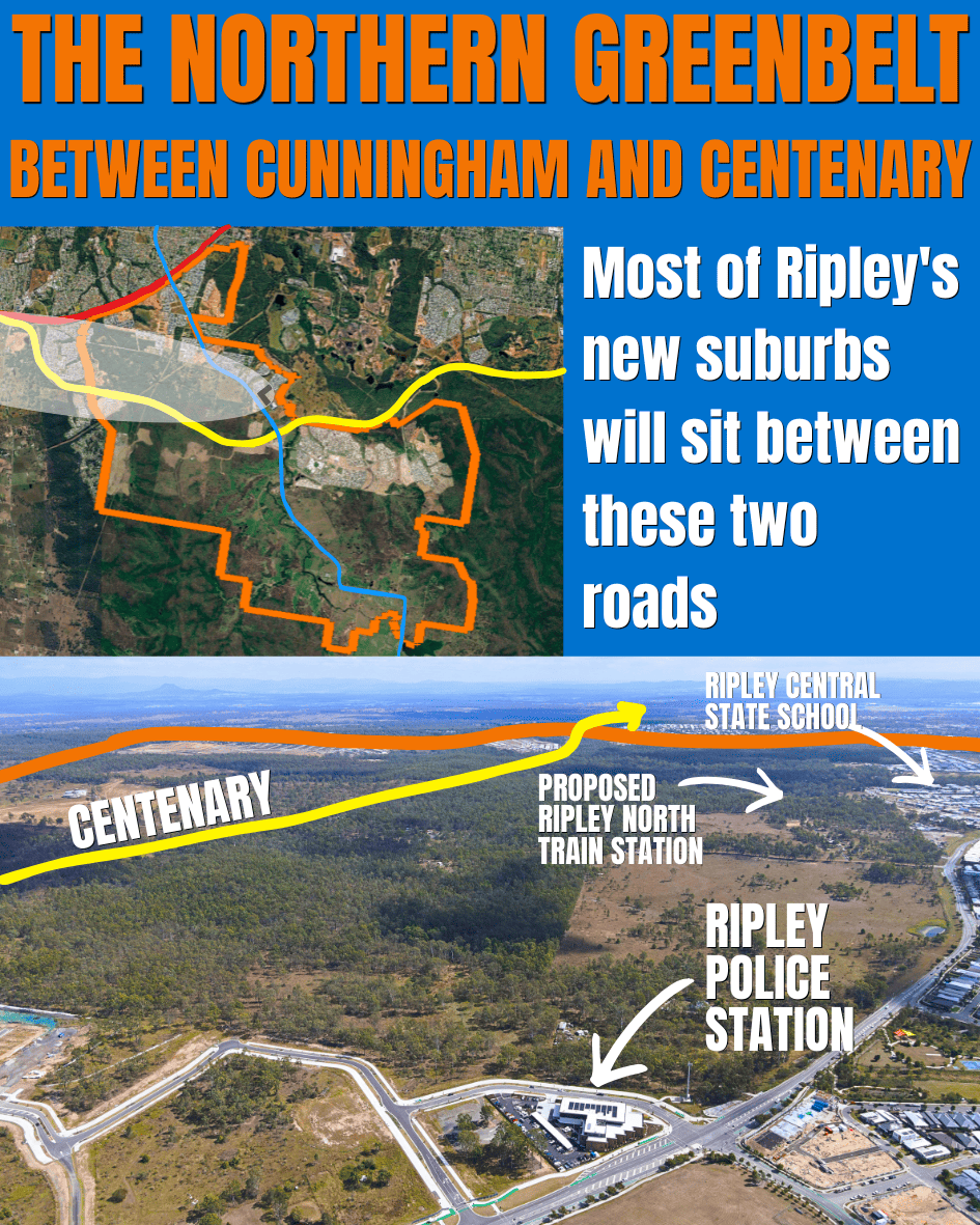
Between Cunningham and Centenary
This green-looking strip between Binnies Road and the Centenary Motorway is not empty background land. It is part of the planned northern buildout around Ripley Town Centre.
Why this strip matters
- The services are already landing. This side is not waiting for the full buildout before everything arrives. Ripley Town Centre opened in 2018. Ripley Central State School opened on Binnies Road in 2023. The Ripley Ambulance Station project is on Ripley Road. QPS now lists Ripley Police Station at 671 Ripley Road. That is the point: the northern side is already shifting from paddocks to services, even while much of the land around it still looks green.
- The proposed train station. A future Ripley North station has been pencilled in along the protected Ipswich-Springfield public transport corridor running through this area. The corridor has been on planning maps for years. The station itself has not been built, funded or given a firm date. Don’t hold your breath.
- Not all paddocks become houses. Much of the northern land is planned for future neighbourhoods, with the main urban core around Ripley Town Centre. Some of what looks green today will become streets and solar rooftops. Some of it will stay green.
The Urban Core Built Around Ripley Town Centre
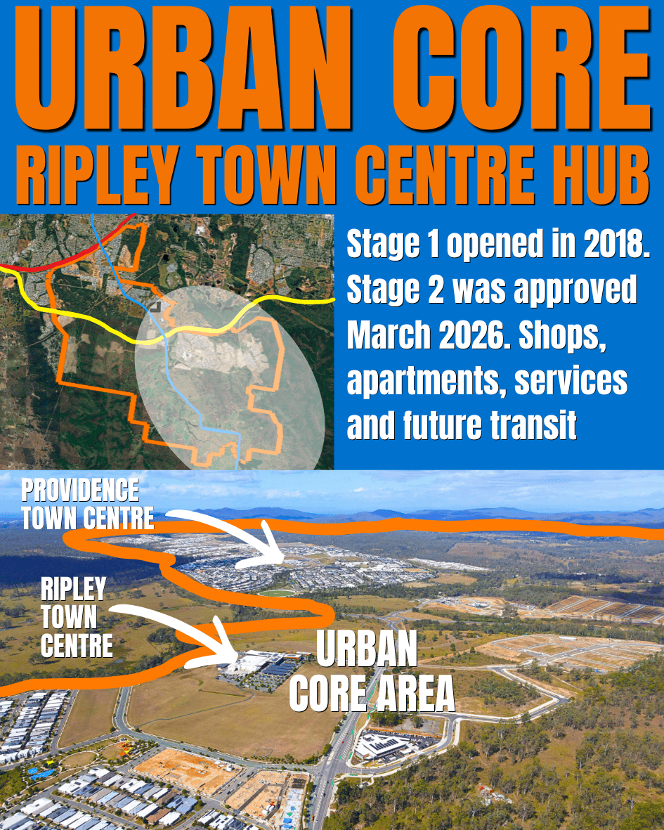
Ripley Town Centre is the designed hub for the entire Ripley Valley PDA
Stage 1 opened in 2018. Stage 2 now has development approval. Shops, apartments, services and future transit will soon be more obvious. And that big patch of green along Ripley Road will finally start to fill in.
Why this is the heart of the plan
- Stage 1 is the tip of the iceberg. The Coles is just the start. The plan has Ripley Town Centre as a small Ipswich CBD: apartments, shops, offices, restaurants, services and a future station / transit interchange. The current built piece is just getting started.
- Stage 2 is the first real test. Stage 2 is the first proper step from “shopping centre” toward “town centre”. It adds about 9,000m² of retail and lifestyle space. Basically 2x what’s there now.
- About that train. A future station and transit interchange are both planned near here. The corridor’s been protected for years. Whether and when the actual line gets built is a whole other conversation.
- What’s at stake. If the urban core grows up properly, Ripley becomes another major centre inside Ipswich. Not Springfield Central, but something in that family. If it doesn’t, the valley risks ending up as nothing more than suburbs with a Coles and Anytime Fitness nearby.
The South Ripley You Know
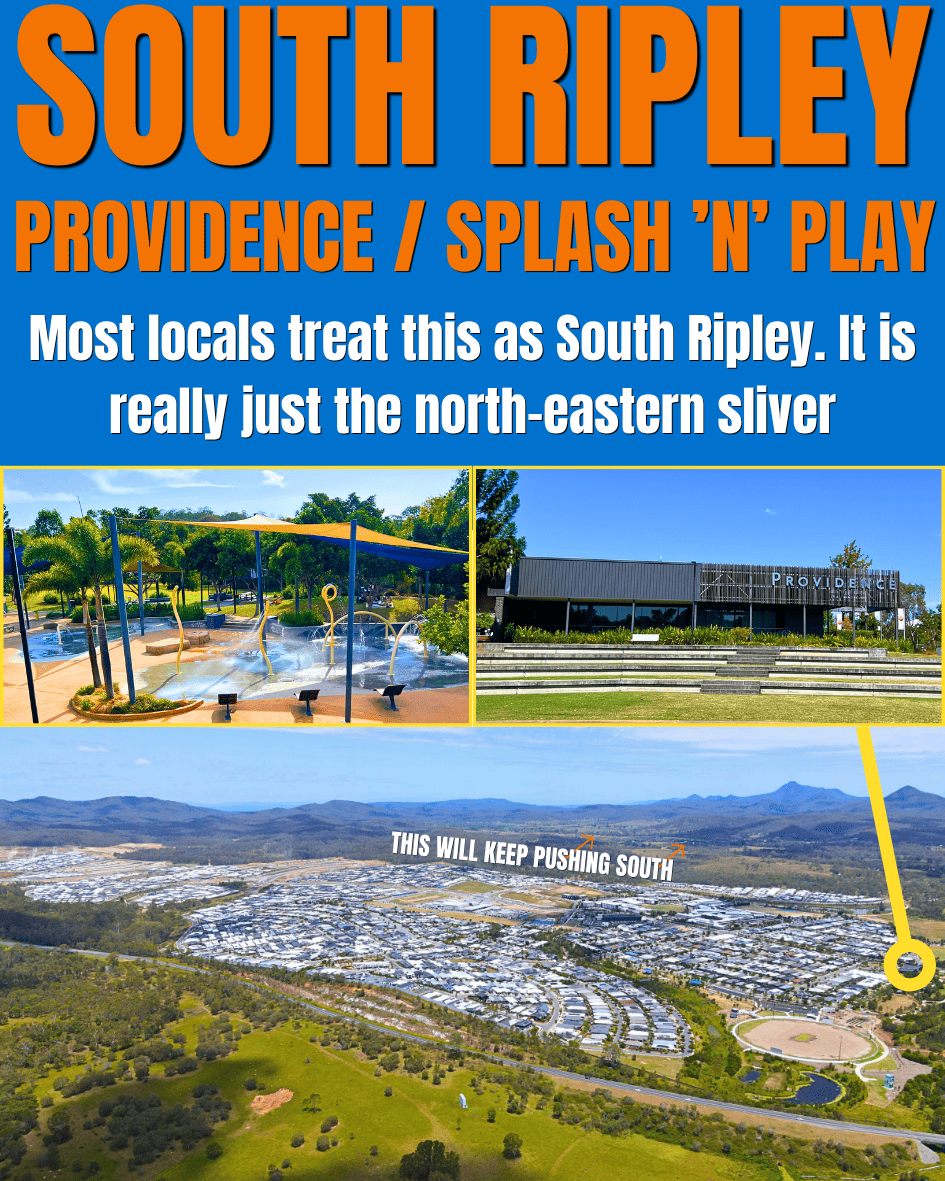
Providence / Splash ‘n’ Play
Most locals treat this as South Ripley. It isn’t. It’s the north-eastern corner of a much bigger suburb.
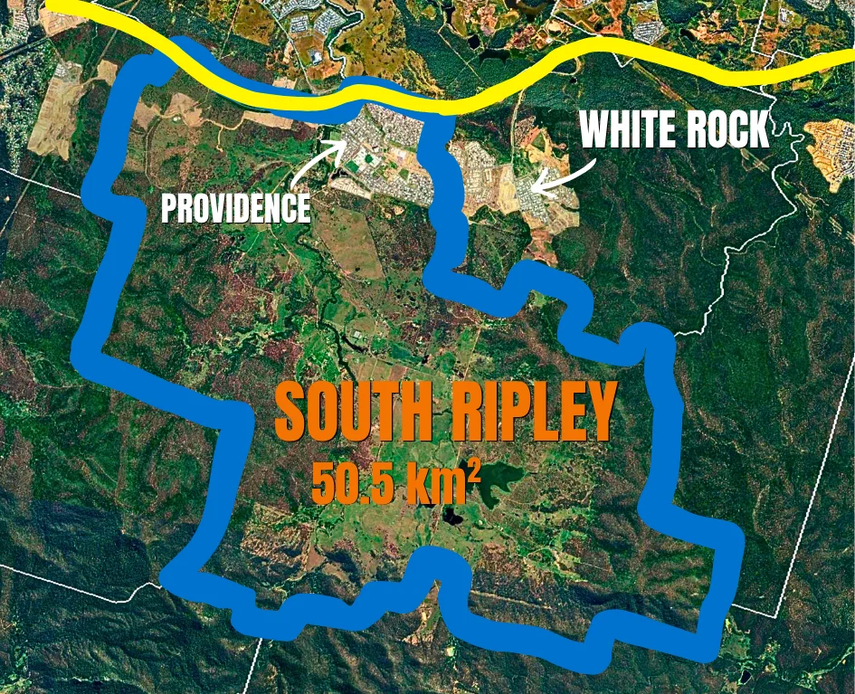
Why Providence isn’t the whole story
- The rest of South Ripley. South Ripley as an actual suburb keeps going well past Providence. Past Bayliss Road. All the way down to Dalys Lagoon. Providence is just the top-right corner.
- The push south. The build won’t stop at Providence’s current edge. The next waves of South Ripley will keep pushing further down the valley.
- Why locals miss it. Most people drive into Providence, go to Splash ‘n’ Play or the playground, then drive home. They never keep going south down Ripley Road.
Have you ever driven down to Dalys Lagoon?
2010 street view looking south down Ripley Rd:
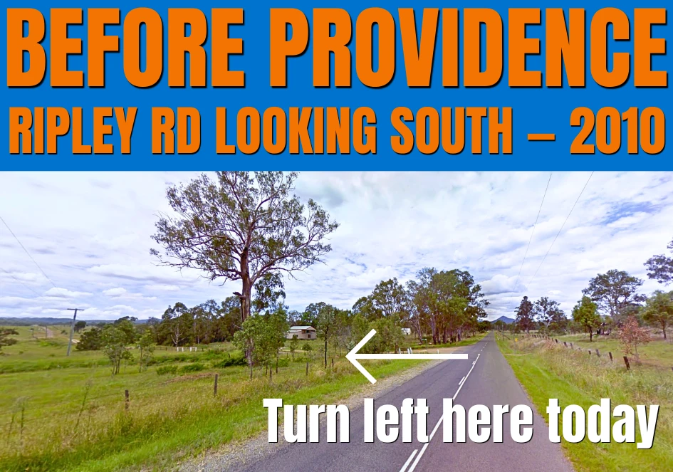
How many of you have driven south down Ripley Rd till you hit Logan?
If you have, you know it turns rural fast.
Back in 2010, Providence Parade was a dirt road called Barrams Road. The old Barrams Road corridor was progressively absorbed into the Providence estate road network during the first major subdivision stages. By mid-2015, Providence Parade was already in public use.
Providence feels established now, but this part of South Ripley changed quickly.
The Rural Frontier
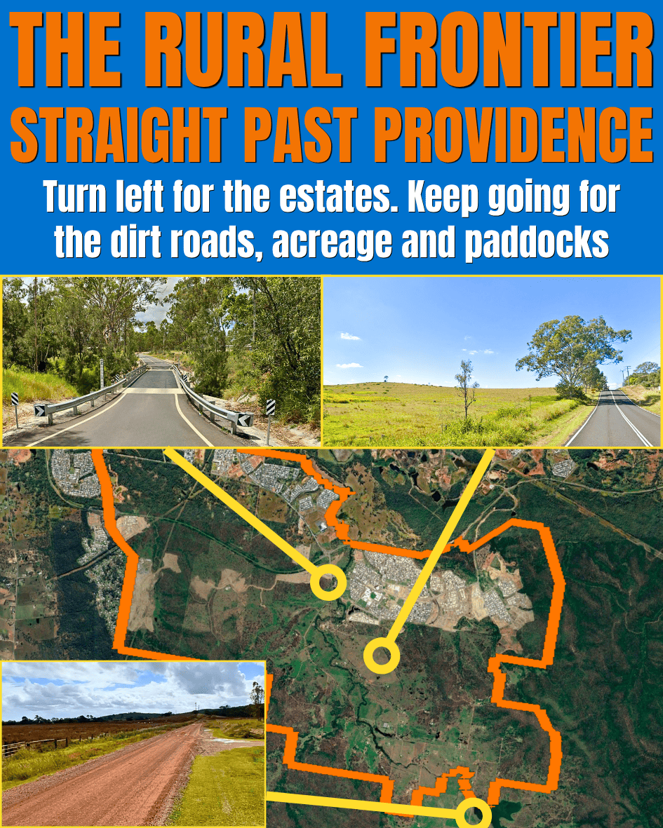
Straight past Providence
Turn left for the estates. Keep going for the dirt roads, acreage and paddocks.
Why it still looks like the country
- Still inside the line. Every paddock and dirt road on this stretch is officially inside the growth area. The plan is for most of it to one day be part of a much bigger built valley. The paperwork’s done. The paddocks are still paddocks.
- The trunk infrastructure problem. Big growth areas don’t fill in evenly. Developers build where roads, water and sewer already exist. Out here the trunk infrastructure is patchy. Until that catches up, the rural look stays.
- The waiting game. Some of these blocks have been in the same family for generations. Others have already been sold to developers and are sitting empty, waiting for their stage to come up.
The Southern Boundary

Daly’s and Bayliss Lagoon
This is the southern edge of the state’s Ripley Valley growth area.
Why the line stops here
- Dalys Lagoon and Bundamba Creek mark the line. Dalys and Bayliss are the natural marker on the planning map. The boundary stops at the land beside them. Then it follows the Bundamba Creek. Then it moves to following straight-line lot overlay boundaries.
- The shock factor. Most locals are surprised the growth area reaches this far south. From the air it’s a long curve through low country. The bit that makes people realise the PDA is way bigger than the suburbs they recognise.
The Bush Backdrop
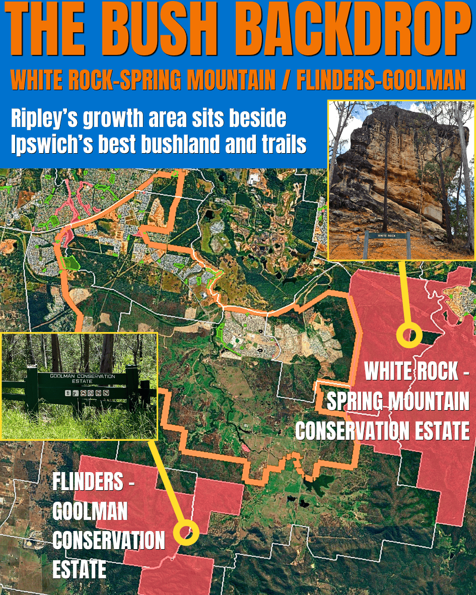
White Rock-Spring Mountain / Flinders-Goolman
Ripley’s growth area sits beside some of Ipswich’s best bushland and trails. If you move here you’re lucky: thousands of hectares to explore on your doorstep. Let’s hope even more investment goes into trail networks and bush conservation here.
What the bushland means for Ripley
- The eastern edge. White Rock-Spring Mountain Conservation Estate touches the PDA boundary directly on the east. Future Ripley neighbourhoods will end at a protected ridge. The conservation land itself is outside the PDA, but it’s right there over the back fence.
- The wider landscape. Flinders-Goolman is further south-west. The official conservation estate doesn’t touch the PDA boundary, but the Flinders-Goolman Range frames the wider landscape.
- What locals get. Bushwalks. Mountain bike trails. Rocky lookouts. White Rock has the famous outcrop the area is named after. Flinders-Goolman has trails for days. All on Ripley’s doorstep.
- Why the boundary stops here. White Rock-Spring Mountain sets a hard eastern edge. The Flinders-Goolman Range helps hold the south-western side. That’s part of why the PDA line bends around the valley instead of just spreading forever.
Thousands Already Call the Ripley Valley Home

Neighbourhoods have already formed inside the growth area
Thousands of homes are already in. Streets, schools, parks, shops, the lot. The rocket-themed park is great too — have you been?
Parts of the valley already have plenty of hustle and bustle
- Queensland’s fastest-growing SA2. Ripley SA2 added 3,131 people in 2024-25 and grew 15.4%, making it Queensland’s fastest-growing SA2 with more than 2,000 people.
- Providence first, north second. Providence in South Ripley was the first proper wave most locals noticed. Now it has thousands of homes, schools, parks and Splash ‘n’ Play. The northern Ripley estates are filling in fast too. Build is happening on both sides of the Centenary at once.
- The flow-on. Schools turned up because families turned up. Shops at Ripley Town Centre exist because there are enough locals to keep them open. The police station is here because the population (and growth outlook) justified it.
Development Gold Rush
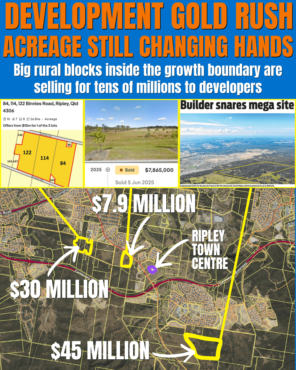
Acreage still changing hands
Big rural blocks inside the growth boundary are selling for tens of millions to developers.
What the prices say
- $7.9 million for farmland. A 15-hectare block on Ripley Road sold for $7.9 million in June 2025. From the road, it still looks like working farmland. You’ve probably seen the horses there as you’ve driven past. The buyer paid $7.9 million for what the land could be, not what it is. Obviously.
- $30 million on Binnies Road. A three-block package is on the market with offers from $30 million for the lot. One big slice of land inside the PDA, big enough to plan a whole neighbourhood on. That is the kind of land developers circle.
- $45 million for the Rawlings family land. Ausbuild paid $45 million for a roughly 65-hectare South Ripley site just south of Providence. The land was sold on behalf of the Rawlings family. The same Ipswich name behind the old Rawlings shoe and menswear store in Brisbane Street. Ray White said the campaign drew 146 enquiries and eight formal offers. That’s developer money, not farmer money.
- Just signals. A high sale price doesn’t tell you what gets built or when. It tells you developers are paying big numbers right now. Whether anything actually gets built is a separate fight. The closer the land is to roads, services and neighbourhoods already in place, the more expensive it gets.
- Why this changes how you read the rest. Every other section in this article shows land that looks rural today. This one shows what that same land is worth on paper. The paddocks haven’t changed. The price tags have. That’s the gold rush.
The Long View Looking North
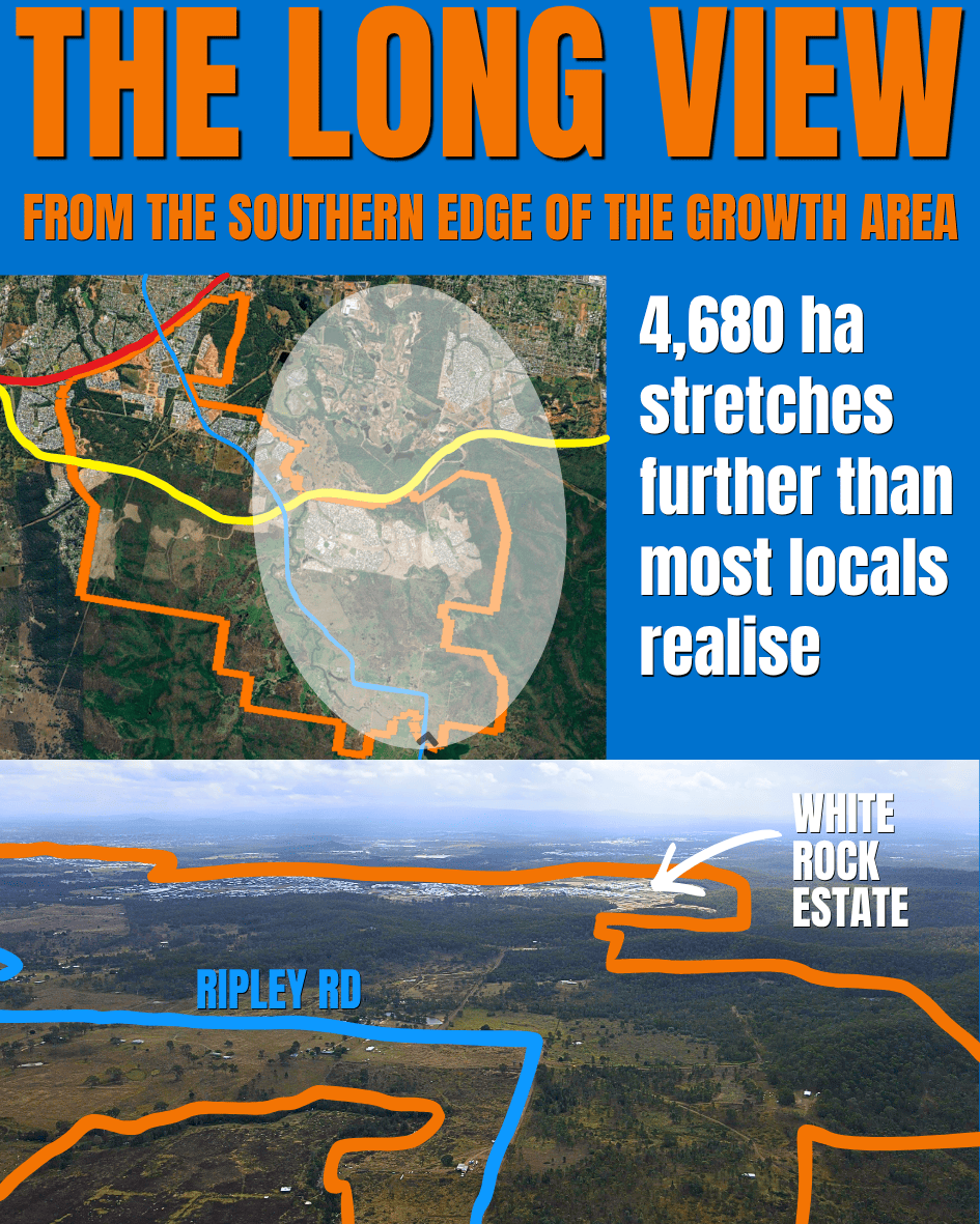
From the southern edge of the growth area
4,680 hectares stretches further than most locals realise.
What 4,680 hectares actually feels like
- 4,680 hectares feels different from up here. It’s a number until you see it. A lot of land to plan. A lot of land to build. A lot of land to fill with houses and people and roads and parks. Even with thousands of new residents arriving each year, this still takes decades.
- The long way to fill in. Even with thousands of homes already built, most of what’s in this drone shot is still empty. Ripley Valley has decades of build-out ahead.
What’s Next
That’s the valley.
The line on the map.
The two halves split by the Centenary.
The northern green strip waiting to fill in.
The urban core.
Providence in the corner.
The rural frontier south of it.
The lagoon at the bottom.
The bushland on the side.
The neighbourhoods already lived in.
The acreage selling for millions.
The long view across all of it.
Now you’ve seen what’s inside the line.
The next question is the one Part 2 answers.
What did the masterplan say all this land was supposed to become?
Sources
- Ripley Valley — edq.qld.gov.au
- Ripley Valley Priority Development Area — ipswich.qld.gov.au
- Ripley Valley Development Scheme Amendment No. 2, 1 July 2025 — edq.qld.gov.au
- Population growth, regional Queensland, 2024-25 — qgso.qld.gov.au
- Ipswich to Springfield Public Transport Corridor Study — tmr.qld.gov.au
- Big News: Stage 2 at Ripley Town Centre is Taking Shape — amoryripley.com.au
- Ausbuild acquires 65.75ha South Ripley site for $45 million — raywhitecommercial.com