
Conservation Estates at a Glance
- Enviroplan defined. Since 1996 it is councilŌĆÖs landŌĆæbuy and care program. $46 levy on every rates notice funds it. 2035 goals are to finish wildlife corridors, close a $1.2ŌĆ»million care gap and launch Indigenous ranger team.
- Twelve estates. Largest: White RockŌĆæSpring Mountain ŌĆō 2,992 ha. Smallest: Woodend Nature Centre ŌĆō 1.8 ha.
- WhatŌĆÖs next. Council will open new tracks at Grandchester, ramp up weed and fire budgets, deploy drones and camera traps, and buy 32ŌĆ»ha at SouthŌĆ»Ripley.
Ipswich City Council owns or manages 6,671┬Āhectares of bushland through Enviroplan. This land sits in 12┬Āestates and reserves and equals┬Ā6% of the local government area.
Staff have recorded 2,000┬Ānative plant and animal species on these sites. Key wildlife includes Koalas, Glossy┬ĀBlack-cockatoos and Brush-tailed┬ĀRock-wallabies. Rare plants grow there as well, such as the Plunkett┬ĀMallee and the Swamp┬ĀTea-tree forest at Purga.
The Yuggera and Ugarapul peoples hold deep ties to these places. White┬ĀRock’s sandstone bluff, Nugum, is a women’s teaching place. Visitors may walk to the base but must not climb the rock known as White Rock.
Public estates give safe walks, lookouts, picnic lawns, one campground and one all-abilities boardwalk. White Rock alone recorded 54,000 visits in 2023-24.
These reserves cool suburbs, slow floods, store carbon and give people nearŌĆæcity bush time.
Explore More Ipswich Gold:
Land Acquisition Timeline
- 1997 – Purga Nature Reserve 17 ha; first White Rock freehold about 600 ha; Kholo (Cameron’s Scrub) initial about 100 ha.
1998 – Purga add-on 16 ha; Flinders-Goolman starter block 474 ha; Kholo extension 37 ha; major White Rock core 1,250 ha.
- 1999 – White Rock west 414 ha; Purga final lots 105 ha; Flinders-Goolman big link 1,201 ha; Stirling Road Rosewood Scrub 32 ha.
- 2000 – Hillview Drive river corridor 38 ha; three White Rock gap-fills 213 ha, 33 ha, 51 ha; Hardings Paddock (Flinders) 228 ha.
- 2004 – Springfield Lakes wildlife-corridor strip 2 ha (gift) added to White Rock.
- 2006 – Flinders-Goolman slope 61 ha; Springfield arterial offsets to White Rock 73 ha and 147 ha.
- 2008 – Kholo west parcel 18 ha.
- 2009 – Kholo central parcel 44 ha.
2010 – Kholo north 33 ha; Mount Grandchester first three buys 158 ha, 138 ha, 259 ha.
- 2011 – Springfield Lakes link to White Rock 172 ha; Kholo fill-in 26 ha; Mount Grandchester spur 65 ha.
- 2012 – Flinders-Goolman Ripley buffer 40 ha; Ripley Valley north link 140 ha.
- 2013 – Mount Grandchester addition 186 ha; White Rock trail linkage 1 ha.
- 2014 – Redbank Rifle Range 129 ha transferred to Council, expanding White Rock north-east.
- 2017 – Flinders-Goolman Mount Goolman gap 57 ha; Mount Grandchester ridge 87 ha.
- 2020 – Mount Grandchester co-buy with corridor partners 63 ha.
- 2024 – Flinders Peak north side koala forest 93 ha.
- 2025 – South Ripley Conservation Reserve (proposed) 32 ha – newest Enviroplan site.
White RockŌĆōSpring Mountain Conservation Estate

White Rock at a Glance
- Visitor draw. Roughly 54,000 people walked its tracks in 2023-24, making it the cityŌĆÖs busiest nature spot.
- Cultural rule. Nugum, the sandstone bluff, is sacred; the summit is offŌĆælimits and hikers must stop at the base.
- Corridor hub. It anchors the eastern end of the 60┬Ākm FlindersŌĆōKarawatha wildlife corridor.
- Size & status. The estate spans 2,992 ha of council freehold and is Ipswich’s busiest bushland destination. It adjoins but remains separate from a smaller state-owned park.
- Acquisition story. Council began buying lots in 1997, secured the 1,250┬Āha core by 1999 and expanded to almost 3,000┬Āha by 2011.
Note: That blank rectangle beside White Rock is StateŌĆæowned conservationŌĆæpark land. ItŌĆÖs excluded from the Ipswich City Council parks layer and therefore doesnŌĆÖt display.
- Former use. Most land was lightly grazed or logged, while 129┬Āha served as the WWII Redbank Rifle Range and still shows firing mounds.
- Ecological value. Sandstone ridges protect the largest nearŌĆæcity tract of dry eucalyptŌĆæheath mosaic.
¤Å×’ĖÅ Contains the headwaters of 7 creeks:
Woogaroo Creek, Mountain Creek, Opossum Creek, Six Mile Creek, Bundamba Creek, Goodna Creek, Sandy Creek (Camira). Combine to drain every compass point of the Conservation Estate. The rainfall is carried to the Brisbane River or north-west to the Bremer River.
- Key wildlife. Powerful Owls, Glossy BlackŌĆæcockatoos and regular Koalas indicate healthy mature forests.
- Cultural links. Nugum is a women’s teaching place for Yuggera and Ugarapul peoples. Visitors may walk to the base but must not climb.
- Visitor access. About 30┬Ākm of signed trails allow hiking, mountainŌĆæbiking and horse riding from Paperbark Flats. Dogs are excluded.
- Management focus. Rangers conduct mosaic burns and target Cat’s Claw Creeper in creek lines while repairing stormŌĆæeroded tracks.
- Main threats. Heavy visitation brings weed seed, litter and offŌĆætrack walking, controlled through wayŌĆæfinding signs and media messaging.
- Funding line. Enviroplan allocated about $200,000 in 2023 for rangers, burns and trail upkeep.
FlindersŌĆōGoolman Conservation Estate

FlindersŌĆōGoolman at a Glance
- Highest summit. Flinders Peak tops out at 678┬Ām, rewarding sturdy climbers with 360ŌĆædegree Scenic Rim views.
- Camp under stars. Hardings┬ĀPaddock hosts the networkŌĆÖs only bush campground and horse yards.
- Ancient volcano. Rugged basalt slopes nurture pockets of dry rainforest uncommon in southŌĆæeast Queensland.
- Size & status. Council controls 2,250┬Āha that merge with the 519┬Āha state park, giving 2,769┬Āha of contiguous forest.
- Acquisition story. The first 474┬Āha were bought in 1998 and gapŌĆæfilling lots were still added in 2024.
- Former use. Lower slopes carried cattle while Hardings Paddock was a family farm. Steep peaks escaped clearing.
Ecological value. Basalt soils host dry rainforest pockets amid open forest, forming the regionŌĆÖs largest intact lowŌĆæelevation eucalypt block.
- Key wildlife. BrushŌĆætailed RockŌĆæwallabies breed on cliffs. Glossy BlackŌĆæcockatoos feed in sheŌĆæoaks. Flinders Plum grows in gullies.
- Cultural links. Traditional Owners recognise Flinders Peak as part of a songline. Some tracks were shifted to avoid initiation grounds.
- Visitor access. Hardings┬ĀPaddock offers picnic lawns and the only campground, while the Flinders Peak trail is a strenuous climb.
- Management focus. 96 hectares were hazardŌĆæreduced by burning in 2023. Crews combat lantana and maintain ropes on steep trail sections.
- Main threats. Steep terrain makes rescues costly and track erosion severe after heavy rain.
Funding line. Annual operating spend is roughly $300,000, the highest of any estate.
Purga Nature Reserve

Purga at a Glance
- Boardwalk stroll. A 350┬Ām elevated path lets wheelchairs glide through the shady swamp.
- Night chorus. After summer storms the reserve echoes with frenetic frog calls.
- Healing history. TeaŌĆætree leaves from this wetland were traditionally used as antiseptic medicine.
- Size & status. Purga safeguards 139┬Āha of wetland and open woodland. Its boardwalk makes it the networkŌĆÖs most all-abilities accessible estate.
- Acquisition story. Four lots were bought from 1997 to 1999 for about $300,000, the first Enviroplan purchases.
- Former use. Known as GammieŌĆÖs Swamp, it was a cattle watering hole. Clearing was minimal due to boggy soils.
Ecological value. The critically endangered Swamp TeaŌĆætree forest here is the largest intact example left in Australia.
- Key wildlife. Koalas feed in adjacent blue gums while BlackŌĆæchinned Honeyeaters visit in spring.
- Cultural links. Elders regard the area as a healing place where teaŌĆætree oils were used medicinally.
- Visitor access. A short gravel circuit and the boardwalk offer an easy, dogŌĆæfree nature experience.
- Management focus. Fire is excluded from the swamp core, while lantana and para grass are sprayed on edges.
- Main threats. Boardwalk timber ages fast in wet conditions and vines seed in after floods.
- Funding line. Operating costs sit around $30,000 a year, the highest perŌĆæhectare in the network.
Mount┬ĀGrandchester Conservation Estate

Grandchester at a Glance
- Corridor link. Its ridge-lines bridge habitat between Ipswich and Main Range National Park.
- Cool refuges. Higher slopes provide future shelter for wildlife as lowland temperatures rise.
- Opening soon. Estate stays closed while scientists finish baseline surveys. Council has budgeted $80,000 for track works and will open public trails once infrastructure and cultural approvals are in place.
- Size & status. The estate covers 1,037┬Āha on the Little Liverpool Range and is currently closed to visitors.
- Acquisition story. Enviroplan assembled the property from 2010 to 2020, spending about $2┬Āmillion including $831,000 for a 63┬Āha block in 2020.
- Former use. Hills were lightly grazed and selectively logged, leaving ironbark woodland and regenerating vine thicket.
- Ecological value. The land plugs a corridor gap and offers climateŌĆæchange refuges at higher elevation.
Key wildlife. Surveys recorded glossy blackŌĆæcockatoos, brush-tailed rock-wallaby, koala and listed southern greater gliders as a high-probability species due to their presence just south in the Hidden Vale Nature Refuge.
- Cultural links. Traditional Owner groups are mapping story places before any visitor track is built.
- Visitor access. No public entry yet. A lowŌĆæimpact ridge walk is proposed and budgeted.
- Management focus. Contractors treat lantana and feral deer while rangers install fireŌĆæbreaks.
- Main threats. Feral deer numbers are rising and some eroding slopes need stabilisation.
- Funding line. Care costs average under $90 per hectare, roughly $90,000 annually.
Mount┬ĀBeau┬ĀBrummell Conservation Park
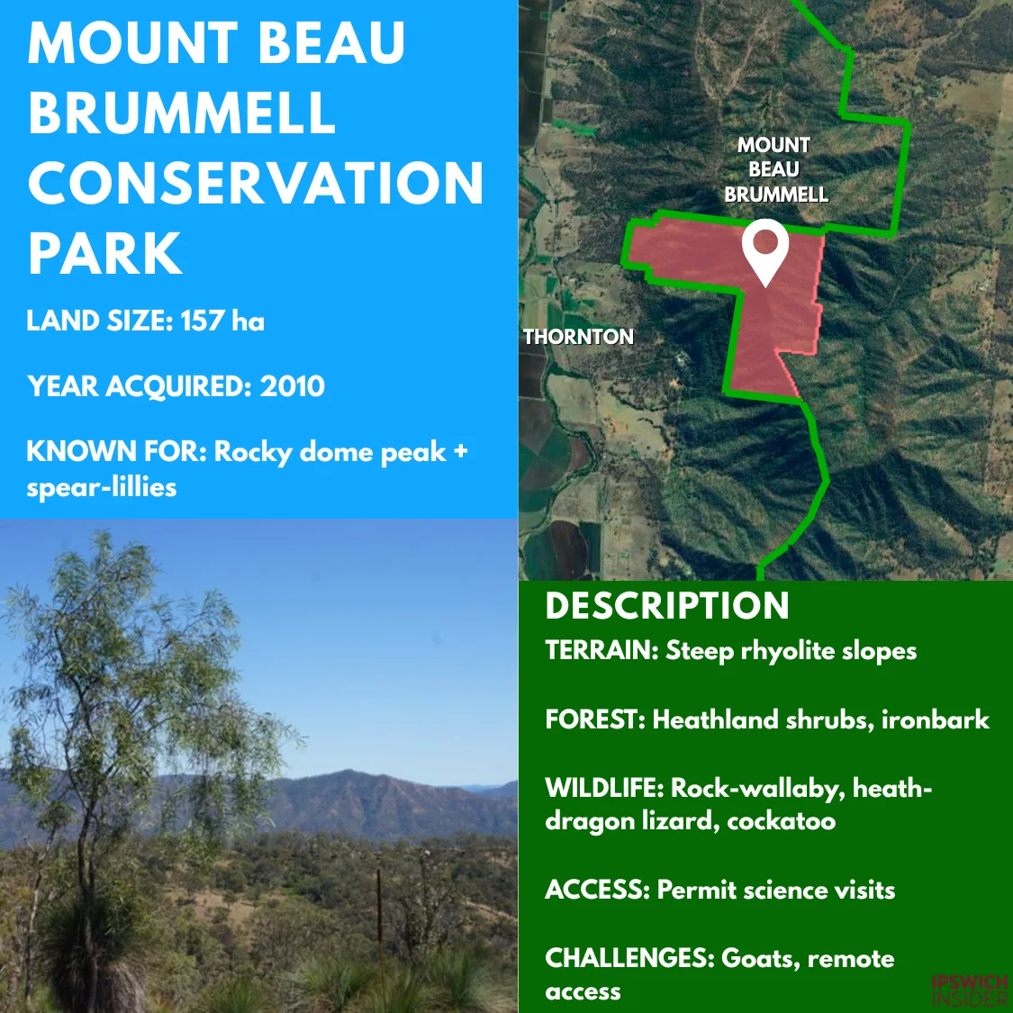
Beau Brummell at a Glance
- Fire bloom. Giant spearŌĆælilies shoot 3ŌĆæmetre spikes the year after a mild burn.
- Sky platform. The rhyolite dome (mountain-top) offers panoramic views from Ipswich plains to the Scenic Rim.
- Permit only. Entry is restricted to protect fragile cliffŌĆætop heath and wallaby dens.
- Size & status. A 157┬Āha state park kept permitŌĆæonly to protect fragile cliff habitat.
- Acquisition story. Declared a conservation park in 2010 on state land; no Enviroplan purchase was required.
- Former use. Lower flanks saw light grazing, while summit faces stayed wild.
- Ecological value. Montane heath with spearŌĆælilies provides altitudinal refuge for wallabies in hotter climates.
- Key wildlife. BrushŌĆætailed RockŌĆæwallabies and mountain heath dragons inhabit crevices.
- Cultural links. Elders regard the peak as a lookout on traditional routes. A cultural survey finished in 2022.
- Visitor access. Scientific research permits only.┬Ā No formal tracks or signage.
- Management focus. Occasional aerial goat shoots and ropeŌĆæaccess weed sorties.
- Main threats. Goat browsing loosens thin soils and dislodges spearŌĆælilies.
- Funding line. Budget is lowŌĆömainly helicopter pestŌĆæcontrol flights every second year.
Kholo Enviroplan Reserve (CameronŌĆÖs┬ĀScrub)
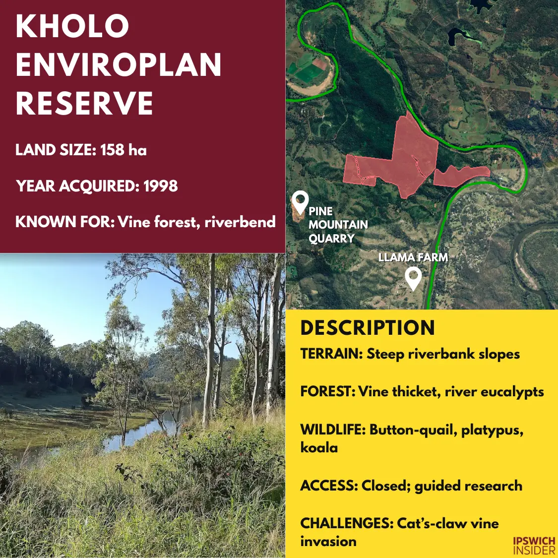
Kholo at a Glance
- Riverside gorge. Steep banks plunge into a deep pool where Platypus are often sighted.
- Dark green tunnel. Vine tangles create rainforestŌĆælike shade even at midday.
- Story trees. Scarred trunks show centuries of traditional owner craftwork.
- Size & status. The 158┬Āha vineŌĆæforest block sits on a river bend and is closed except by permit.
- Acquisition story. Five lots were bought between 1998 and 2011 for roughly $1.2┬Āmillion.
- Former use. Mixed grazing with dense scrub left untouched on steep riverbank.
- Ecological value. Best remaining dry vine forest on the Brisbane River and a vital canopy crossing point for wildlife.
- Key wildlife. LloydŌĆÖs Native Olive grows here and camera traps hint at blackŌĆæbreasted buttonŌĆæquail.
- Cultural links. Scar trees and tool scatters show long river use by traditional owners.
- Visitor access. No public tracks. Limited walks will depend on cultural approval and weed reduction.
- Management focus. Cat’s Claw vine is sprayed on edges and riverbank stabilisation follows floods.
- Main threats. Edge vines and floating litter after major flood peaks.
- Funding line. About $50,000 a year funds weed contractors and patrols.
Hillview┬ĀDrive Reserve

Hillview Drive at a Glance
- Easy escape. Families finish the 1.1 km loop in under 20 minutes.
- Hide and seek. A simple bird hide lets watchers spy kingfishers unseen.
- Flood buffer. Low flats soak up Brisbane River overflow, easing downstream peaks.
- Size & status. A 38┬Āha eucalypt strip beside the Brisbane River is fully open to visitors.
- Acquisition story. Council paid $52,000 in 1999 for two pasture lots.
- Former use. Hobby grazing blocks with remnant river flat forest.
- Ecological value. Acts as a stepping stone that lets gliders and owls cross from Ipswich estates to DŌĆÖAguilar National Park.
- Key wildlife. Powerful owls roost in old riverŌĆæred gums and tusked frogs breed after spring rain.
- Cultural links. Riverbank shell middens recorded during surveys remain offŌĆætrack.
- Visitor access. 1.1 km bush loop, small bird hide and informal picnic spot. Dogs on leash permitted.
- Management focus. Rangers slash grass fireŌĆæbreaks and remove flood debris.
- Main threats. Riparian weeds and rubbish washed in during floods.
- Funding line. Annual care budget is about $10,000 for trail and weed trims.
Haig┬ĀStreet Quarry Reserve
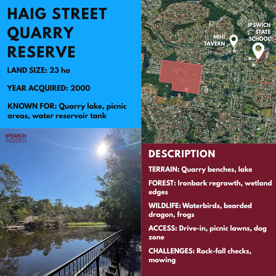
Haig Street at a Glance
- Basalt classroom. Exposed quarry walls reveal 25ŌĆæmillionŌĆæyearŌĆæold lava layers for school geology lessons.
- Cool lake dive. The flooded pit is about 14┬Ām deep, providing yearŌĆæround refuge for waterbirds.
- Pup playground. A fenced offŌĆæleash zone keeps both wildlife and dogs happy.
- Size & status. The reclaimed 23┬Āha quarry is a popular urban reserve with a waterbird lake and dog park.
- Acquisition story. Land was retained by council after the quarry closed in the 1970s, so no Enviroplan purchase cost.
- Former use. Basalt quarry benches supplied road stone for decades before rehabilitation.
- Ecological value. Regenerating ironbark forest and a deep pool now support woodland birds and aquatic life.
- Key wildlife. Pacific bazas hunt over the lake and eastern water dragons bask on rock edges.
- Cultural links. Interpretive signs explain the siteŌĆÖs mining history rather than Indigenous stories.
- Visitor access. Sealed car park, toilets, picnic lawns and short loops. Dogs welcome in the fenced area.
- Management focus. Weekly mowing and quarterly safety inspections check quarryŌĆæwall stability.
- Main threats. Occasional rockŌĆæfalls from old benches and garden plants dumped over fences.
- Funding line. About $35,000 covers mowing, inspections and minor repairs each year.
Denmark┬ĀHill Conservation Reserve
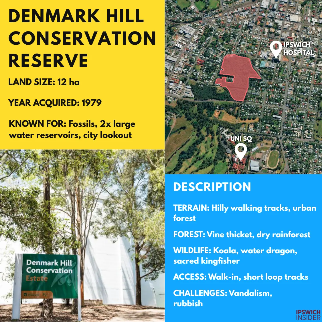
Denmark Hill at a Glance
- Deep time. Visitors can touch leaf and fish fossils dating back 225┬Āmillion years.
- Sky ladder. The 20┬Ām steel lookout rises above the canopy for cityŌĆætoŌĆæscarp vistas (now closed due to a safety incident in 2021).
- Bats at dusk. Hundreds of microbats swirl out of old mine shafts every evening.
- Size & status. 12 hectares of bush 5 minutes from Ipswich CBD are open daily with short loops.
- Acquisition story. Declared a state conservation reserve in 1979; Enviroplan funded major upgrades in 2021.
- Former use. Coal mining tunnels ran under the hill and early water reservoirs stood on top.
- Ecological value. Dry vine thicket regeneration and exposed Triassic fossils create a rare urban nature site.
- Key wildlife. Squirrel gliders glide between restored canopy gaps. Southern greater gliders and sugar gliders shelter in taller hollows. Grey-headed flyingŌĆæfoxes camp here when blossoms peak.
- Cultural links. Historic mine portals and fossil displays connect visitors with IpswichŌĆÖs mining past.
Visitor access. New natureŌĆæplay equipment, toilets and the skyline lookout attract families day and night.
- Management focus. GardenŌĆæescape vines are removed quarterly and safety checks inspect old mine openings.
- Main threats. Backyard weeds creep in and vandalism occasionally damages railings.
- Funding line. About $60,000 a year covers paths, signage and weed crew.
Woodend Nature Centre / Ipswich Pteropus Conservation Park
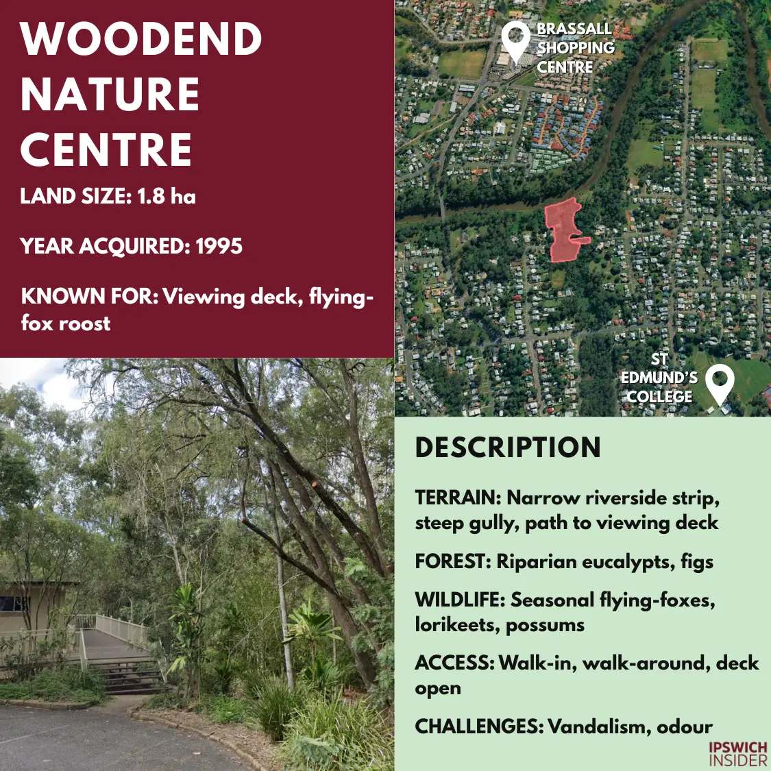
Woodend at a Glance
- Seasonal roost. Bat numbers swing with blossom cycles, from fewer than 200 to more than 1,000 in a good flowering season. Was home to more than 250,000 bats in the 70s/80s.
- Urban classroom. School groups use a sound dish on the deck to hear bat chatter in real time.
- Blossom highway. Roosting bats pollinate forests up to 50┬Ākm away during nightly foraging flights.
- Size & status. A tiny 1.8┬Āha block protects a flyingŌĆæfox day roost and is open for quiet viewing.
- Acquisition story. Gazetted in 1995 on state land; Enviroplan later funded the deck and signs.
- Former use. Natural riparian forest with minimal disturbance.
- Ecological value. FlyingŌĆæfoxes pollinate eucalypts across southŌĆæeast Queensland, so a safe urban camp benefits regional forests.
- Key wildlife. Roost counts now peak in the 100s-1,000s, still regionally important.
- Cultural links. The deck hosts school talks that explain flyingŌĆæfox cultural stories and ecosystem roles.
- Visitor access. Short boardwalk leads to the deck. Dogs are excluded to avoid stressing bats.
- Management focus. Rangers remove rubbish and replace interpretive panels damaged by weather or vandals.
- Main threats. Odour complaints and weed seedlings dropped by floods.
- Funding line. About $20,000 a year keeps the deck safe and weeds in check.
Ric┬ĀNattrass Environmental Park
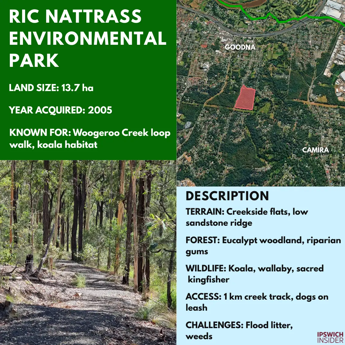
Ric Nattrass Park at a Glance
- Living tribute. The park hosts an annual citizenŌĆæscience spotlight walk in honour of Ric┬ĀNattrass.
- Flood sponge. Wide creek flats absorb storm surges, protecting downstream homes in Redbank.
- Nest network. Dozens of wooden boxes give Squirrel┬ĀGliders safe hollows in young trees.
- Size & status. The 13.7┬Āha creekŌĆæside reserve is open with a 2┬Ākm loop trail.
- Acquisition story. Land was acquired in 2005 and named in 2006 to honour Ric┬ĀNattrass; price not published.
- Former use. Buffer strip for the old rifle range before rehabilitation plantings began.
- Ecological value. Restored riparian scrub lets wildlife move freely towards the Brisbane River.
- Key wildlife. Tusked frogs breed in quiet pools and squirrel glider nest boxes are ready and waiting.
- Cultural links. An interpretive node tells the story of Ric┬ĀNattrassŌĆÖs conservation legacy.
- Visitor access. Gravel loop with footbridges. Dogs on leash welcome. Occasional spotlight walks.
- Management focus. FloodŌĆætolerant native plantings replace exotics and litter cleanŌĆæups follow heavy rain.
- Main threats. StreamŌĆæbank erosion and debris from upstream suburbs.
- Funding line. Roughly $15,000 a year supports weed, litter and path upkeep.
Stirling Road Reserve
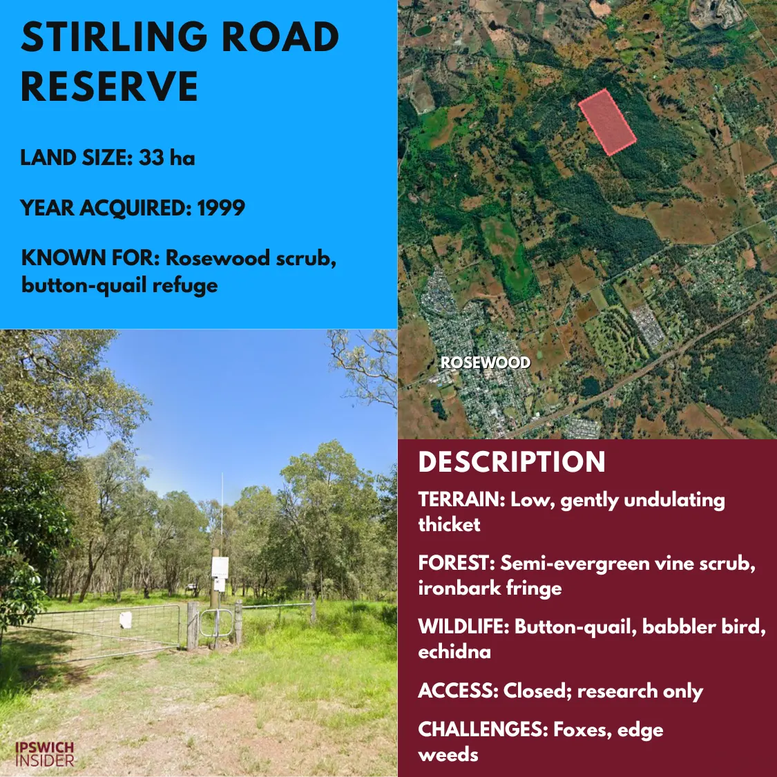
Stirling Road at a Glance
- Hidden birdsong. Dawn brings the distinctive drumroll call of elusive buttonŌĆæquail males.
- Genetic vault. Botanists collect seed here to restore Rosewood Scrub elsewhere in the region.
- Fox fence. A solarŌĆæpowered electric fence is trialled to keep predators out at night.
- Size & status. A 33┬Āha semiŌĆæevergreen vine thicket patch kept closed to safeguard shy ground birds.
- Acquisition story. Bought in 1999; purchase cost was modest for the era.
- Former use. Lightly grazed paddock fringes; dense core scrub remained uncleared.
- Ecological value. Best remnant of the Rosewood Scrub ecosystem and an irreplaceable seed bank.
Key wildlife. Endangered blackŌĆæbreasted buttonŌĆæquail drum on leaf litter and rare BaileyŌĆÖs Cypress trees grow on ridges.
- Cultural links. Elders have requested low visitation until a cultural assessment is complete.
- Visitor access. No public entry. Scientific surveys only under permit.
- Management focus. Fox and feralŌĆæcat control plus quarterly weed patrols keep edges intact.
- Main threats. Predation by foxes and edge drying on this small isolated block.
- Funding line. About $10,000 annually covers baiting, checks and camera servicing.
Sources
- Enviroplan. Ipswich.qld.gov.au.
- Enviroplan Levy. Ipswich.qld.gov.au.
- Enviroplan Annual Progress Report 2022ŌĆæ2023 (PDF). Ipswich.infocouncil.biz.
- Celebrating 25 Years of Enviroplan (PDF). Ipswich.qld.gov.au.
- Enviroplan Timeline. PictureIpswich.com.au.
- Enviroplan Story. Open.ipswich.qld.gov.au.
- Native Wildlife of Ipswich LGA. Des.qld.gov.au.
- Enviroplan Continues to Deliver for Ipswich. IpswichFirst.com.au.
- Conservation Estates and Reserves. Ipswich.qld.gov.au.
- Ipswich Enviroplan Strategic Investment Plan 2025 (PDF). Ipswich.qld.gov.au.