Also check out:
- Case #1: 17 Ipswich Curiosities →
- Case #3: 19 Ipswich Intrigues →

16 Ipswich Peculiarities at a Glance
- Hidden systems: Ipswich hides infrastructure in plain sight. A CBD snorkel vents a carpark, rope bridges move wildlife above traffic, and a missing house lot exists because the power network needs it.
- Growth bottlenecks: A few missing links shape everyone’s day. One short road gap creates a long detour, peak-hour exits choke up fast, and a major rail corridor exists as station names on paper.
- Scrub to gold: Ordinary-looking fringe land is becoming premium development territory. Meanwhile creeks, lagoons, soil, and old boundaries still decide where roads, industry, and suburbs can actually go.
🔢 By The Numbers
- 16 peculiarities in Case 2 of The Ipswich Files
- 114 acres of bushland sitting behind one Deebing Heights cul-de-sac house
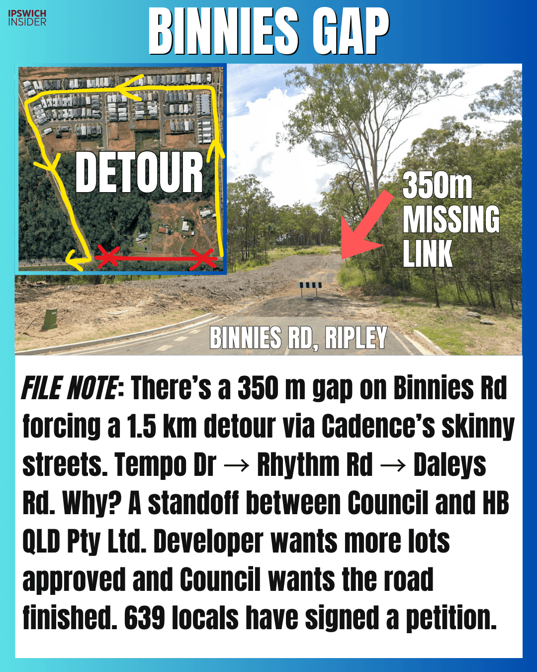
- 350 m of missing Binnies Rd causing lots of headaches
- 1.5 km detour through Cadence (Tempo Dr → Rhythm Rd → Daleys Rd) to get around that missing gap
- 639 locals who’ve signed the petition to finish Binnies Rd
- 9 planned stations on the Ipswich–Springfield corridor
- 23 minutes the promised end-to-end travel time if that corridor becomes a real line
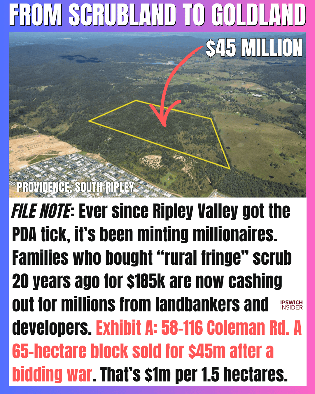
- $45 million paid for 58–116 Coleman Rd, South Ripley after a bidding war
- 65 hectares the size of that Coleman Rd block (pitched as a 420-lot subdivision)
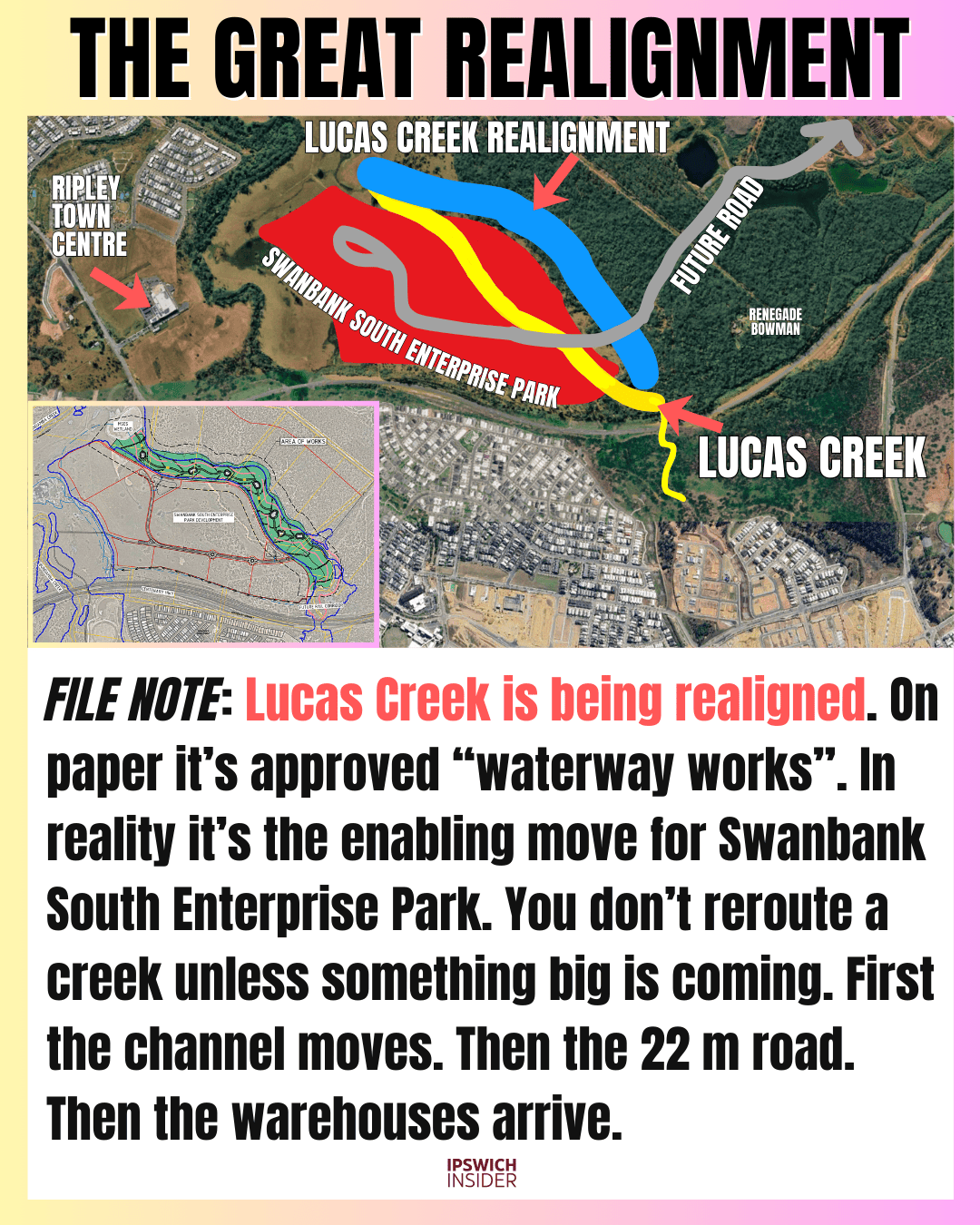
- 22 metres the width of the planned sub-arterial road linked to the Lucas Creek realignment
Everyone loved Case #1 of The Ipswich Files: 17 local curiosities.
So we’re back today with Case 2, and we’re calling this batch: 16 Ipswich peculiarities.
From weird artsy-looking “structures” in the CBD to Ipswich’s most hidden river crossing, to hidden lagoons and banned swimming holes…
This is the stuff you don’t even know you want to know until you know it.
Let’s get stuck right into it.
Here’s Case 2 of The Ipswich Files: 16 local peculiarities.
More Ipswich Gold
Jump to
- CBD snorkel vent
- 114-acre backyard
- White Rock rope bridges
- Swanbank forbidden lake
- Wulkuraka meat hub
- Black soil basics
- Foundry to flat whites
- Hidden river crossing
- Providence power lot
- Daly’s Lagoon
- Binnies Gap detour
- Lucas Creek move
- Garowie strip
- Why Amberley
- Scrubland to goldland
- I2S missing link
The CBD Snorkel

Details
It looks like public art, but it behaves like infrastructure. This is a purpose-built “to-sky” shaft that helps an underground carpark breathe, and in an emergency, helps move smoke out fast.
- Why it exists: Underground carparks trap fumes and heat, so they need engineered airflow.
- Fire mode: In a fire, shafts like this support high-volume smoke exhaust to keep escape routes safer.
- Scale: Big opening = lower resistance = better airflow, especially when fans ramp up.
- Looks intentional: The above-ground form is usually “designed” so it doesn’t read like a shopping-centre vent.
Credit to Kez from @thingstodoinipswich:
@thingstodoinipswich Replying to @andrewmorris15 Mystery solved, guys! 🕵️♀️ A lot of you said it was ventilation for the car park, and I reckon you’re right! ✅ It is a bit of an eyesore though 👀 so what do you think we should do about it? If we were to paint a mural on it, what would the mural be? 🎨 Let me know your ideas in the comments! 💭 📍Corner of Limestone Street & East Street 💚 Kez #thingstoDoInIpswich #DiscoverIpswich #IpswichArt #StreetArtIdeas #LocalCommunity ♬ original sound – MOTORSPORT FILES
Your Own National Park in Deebing Heights

Details
A suburban street that ends in what feels like private bushland is peak Ipswich. The oddity is the contrast: a modern house-and-street scene backed by a single title that reads like a nature reserve.
- How it happens: Old rural holdings can get surrounded by estates when one parcel never subdivides.
- Stalled staging: Sometimes a future stage doesn’t proceed, leaving a “leftover” block attached to one lot.
- Planning friction: Big bush blocks can carry constraints that make carving it up expensive.
- Real-world impact: One owner controls access, firebreaks, and whatever happens next.
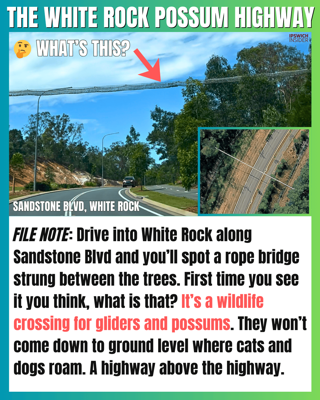
The White Rock Possum Highway
Details
Those rope bridges aren’t there for show. They’re an overhead shortcut for small tree-dwellers that want to stay off the ground and out of reach of predators.
- Target species: Gliders and possums are the usual users because they’re light, fast, and canopy-dependent.
- Koala myth: Locals call them koala bridges, but koalas generally don’t treat rope ladders like roads.
- Why overhead: It keeps animals out of headlights and reduces the “dash across” risk.
- Whole system: These crossings work best when paired with fencing and habitat links on both sides.
Swanbank’s Forbidden Lake

Details
Swanbank Lake has a strong “Ipswich childhood” vibe for a lot of people. The peculiarity now is how firmly it has flipped from summer hangout to no-go zone.
- Back then: A remembered local swimming and fishing spot, especially in warmer decades.
- Water quality: Algae blooms and changing ecology can shut down casual recreation quickly.
- PFAS layer: Contamination investigations harden the advice: avoid contact and avoid fishing.
- Why closed: Once a place becomes “industrial + contaminated”, reopening the gate is slow.
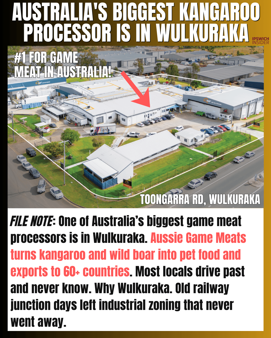
Australia’s Biggest Kangaroo Processor is in Wulkuraka
Details
Wulkuraka looks quiet from the street, but it feeds supply chains you’d never guess. It’s one of those Ipswich pockets where “old rail town” history quietly became “industrial backbone”.
- Rail roots: The area grew around junction logic, and once land is zoned industrial it tends to stay that way.
- Food supply: Meat processing and pet-food ingredients cluster where trucks can move easily and buffers exist.
- Why here: Access, zoning, and “already industrial” land make it cheaper than starting fresh elsewhere.
- Local blind spot: Lots of residents drive past daily without realising what’s made behind those fences.
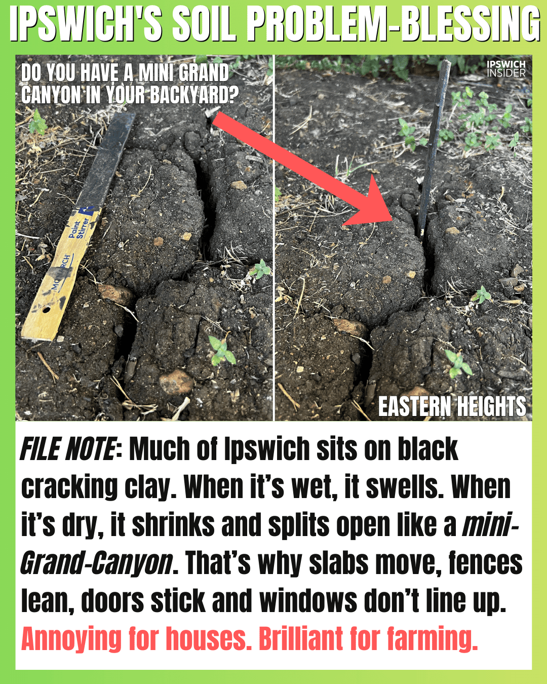
Ipswich’s Soil Problem–Blessing
Details
Ipswich black soil is famous for doing two opposite things well: growing things and moving houses. The same shrink-and-swell behaviour that makes gardens lush can make slabs, fences, and paths look drunk.
- Shrink–swell: It expands when wet and contracts when dry, which creates movement over seasons.
- Cracking: Dry spells open deep cracks that can shift posts and break paving.
- Fertility: High clay content holds water and nutrients, which is why it can grow like mad.
- House reality: Drainage and moisture control matter more here than on sandy soils.
The Foundry That Forges Flat Whites

Details
Brassall has a cafe with cathedral ceilings and industrial bones because it used to be literal industry. The weird part is how completely the place changed jobs while keeping the same heavy-duty shell.
- Industrial DNA: Foundries need volume, ventilation, and hard floors, which is why the space feels enormous.
- Local workhorse: It’s part of Ipswich’s manufacturing story, when “made here” was normal.
- Second life: Repurposing kept the structure useful instead of flattening it and starting again.
- Name payoff: “Foundry” isn’t branding. It’s a leftover fact.
Ipswich’s Most Hidden River Crossing

Details
It’s the kind of crossing you only learn about from locals, not maps. One name becomes two, and suddenly you’re on a bridge that feels like it should be in a secret level of Ipswich.
- Two names: Some call it McKee’s Bridge, others Sellars Bridge, and neither shows up cleanly online.
- Old purpose: Crossings like this often start as working infrastructure for quarries or rural access.
- Access: It’s easier to reach on foot, bike, or by kayak than by “normal road trip”.
- Safety note: Treat it like a backcountry spot. Conditions change and signage is scarce.
The Only Lot in Providence Without a House

Details
This “empty lot” is not waiting for a build. It’s a deliberately kept space for power infrastructure, where the visible pole marks a bigger hidden system feeding the estate.
- Why empty: Utilities need clearance, access, and easements, which don’t mix with backyard fences.
- Network role: It’s a handover point where high-voltage supply transitions into local distribution.
- Reliability: As suburbs grow, these nodes multiply to spread load and reduce choke points.
- Unexpected memorial: The landscaping makes it feel like a pocket park, not “power land”.
The Lagoon Nobody Noticed

Details
Daly’s Lagoon feels like it’s been hiding in plain sight. It’s a natural waterbody that existed long before estate maps, and now sits beside modern growth like an accidental time capsule.
- Name story: The lagoon carries a settler surname that stuck as the district changed around it.
- Natural low point: Basins like this hold water and become obvious “assets” once stormwater planning arrives.
- Wildlife: It’s the kind of place locals swap sightings about, especially when water is holding.
- New visibility: Development didn’t create the lagoon. It just put headlights on it.
Binnies Gap
Details
It’s one of those “how is this still a thing” gaps. A short missing section forces a long detour, pushing everyday traffic and heavy vehicles through streets that were never meant to be a shortcut route.
- The detour: Drivers loop through Tempo Dr, Rhythm Rd, and Daleys Rd to get around the break.
- Why it bites: More cars and trucks on narrow estate roads means more noise, near-misses, and stress.
- The holdup: This isn’t just asphalt. It’s drainage, services, and “trunk” standard delivery.
- Public pressure: The petition exists because the impact is felt street-by-street.
The Great Realignment
Details
Moving a creek sounds like a niche civil project until you realise it’s the first domino. Realignment works are often the “enabling move” that makes a much larger development physically possible.
- What’s happening: The channel alignment is being reshaped and stabilised to suit future flows.
- Why now: Big industrial parks need predictable water management before roads and pads go in.
- Road corridor: Waterway works often pair with new sub-arterial routes that follow the reshaped land.
- The tell: Creeks don’t get shifted for fun. It’s usually a prelude to “something large”.
Garowie’s Secret Entrance
Details
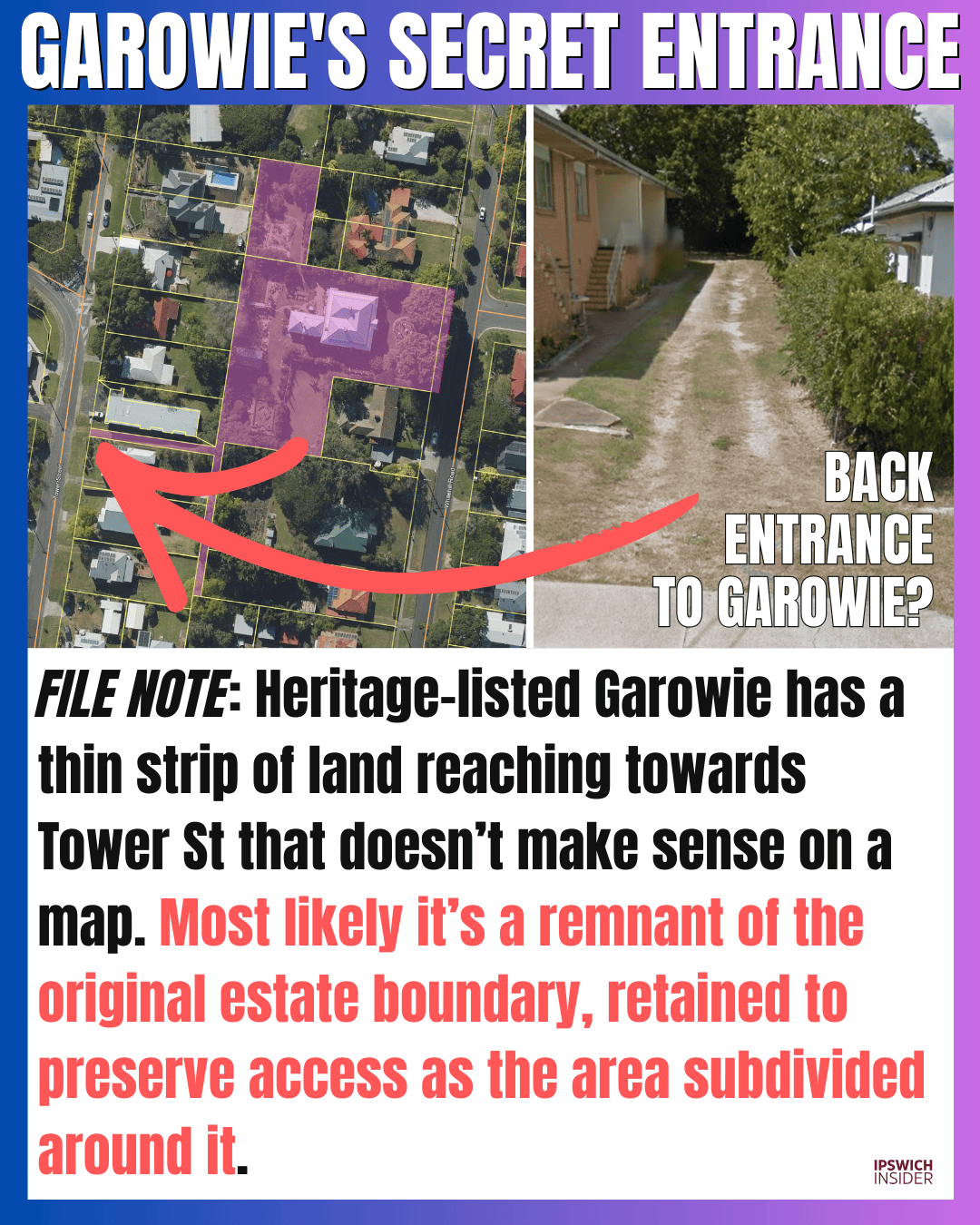
Garowie is heritage, but the map oddity is the thin strip of land that looks like a secret handle. It’s a leftover line from older boundaries that modern streets had to work around.
- Old boundaries: Large estates were subdivided in pieces, and “strips” sometimes remain as proof of the original shape.
- Access rights: Retaining a connection can preserve options for driveways, services, or legal access.
- Why it survives: Once a boundary is set on title, it tends to outlive every later planning idea.
- The vibe: Ipswich history hiding in a skinny rectangle.
Why Australia Chose Amberley

Details
Amberley wasn’t “somewhere out west of Brisbane”. It was selected like an engineering project: test the ground, map floods, check access, then choose the site that can handle big aircraft and bigger expansion.
- Ground truth: Firm subsoil and flat terrain matter more than pretty views when you’re building runways.
- Flood thinking: Surveys reduce the risk of a base that becomes unusable when it’s needed most.
- Logistics: Rail and Ipswich industry meant easier supply, labour, and long-term support.
- Room to grow: Bases aren’t built for year one. They’re built for decades.
From Scrubland to Goldland
Details
Ripley Valley has a rare alchemy. Ordinary-looking rural blocks become headline land the moment the future is locked in, even if the paddocks still look the same.
- Landbanking: Buyers pay for what the land will be, not what it is today.
- Multiplier effect: One rural title can translate into hundreds of future lots once the pathway is clear.
- Proof point: A big sale makes the maths feel real, not theoretical.
- Local impact: Ownership flips first. The landscape change follows.
The Missing Link
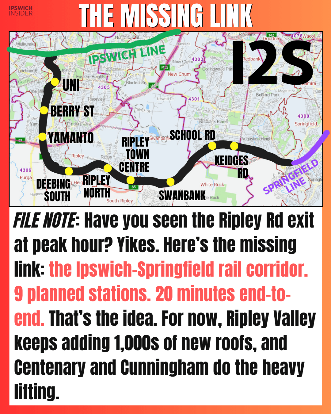
Details
Ripley Valley has station names before it has stations. The Ipswich–Springfield corridor is a planned link that makes perfect sense on a map, and stays peculiarly invisible in daily life.
- Nine stops: Station locations are already sketched out, from UniSQ through Ripley to Redbank Plains.
- Travel idea: The concept is a quick cross-city hop that changes how Ipswich connects to Springfield.
- Right now: Daily movement is still road-first, with Centenary and Cunningham doing the heavy lifting.
- Why it’s odd: The future is named, mapped, and discussed, but not yet built.
Sources
- Swanbank South Industrial Precinct For Sale. CommercialRealEstate.com.au
- Binnies Rd Missing Road Connection Petition. Change.org
- 58-116 Coleman Road, South Ripley Sold. RealCommercial.com.au