
Steepest Streets at a Glance
- Ranking metric: Our Ipswich Steepest Streets Index measures and ranks the steepest 25 m stretch on each street.
- Context figure: the average grade is also measured over a continuous 200-300 m+ segment of the same road (so you can see how long the pain lasts, not just the worst pinch).
- Photo match-up: all slopes correspond exactly to the street sections shown in the Google Earth images.
- Living list: we’ll keep adding climbs as we survey more of Spring Mountain, nearby rural lanes, and any streets you nominate—send your suggestions and we’ll go for a hike.

🔢 By The Numbers

- Outside Ipswich—Explorers Bridge Rd (Mt Crosby, Brisbane): 28 % / 13.1 % avg
- Bluff Buster – Paidley Rd: 26.6 % / 12.1 % avg
- Bellbird Breaker – Surrey Rd: 25 % / 13.6 % avg
- Eric’s Escalator – Eric St: 24 % / 11 % avg
- Denmark Drag – Ellenborough St: 18 % / 12.7 % avg
- Murphy’s Mayhem – Murphy St: 18 % / 12.4 % avg
- Coal Burner – Macrae St: 18 % / 8.8 % avg
- Reservoir Ramp – Jones St: 17.2 % / 11.7 % avg
- Clay Crusher – Clay St: 16.5 % / 11.6 % avg
- Stephenson Slide – Stephenson St: 16 % / 11.2 % avg
- Conte Climb – Conte Cct: 16 % / 12.5 % avg
- Panton Punch – Panton St: 15 % / 10.4 % avg
- Winland Wall – Winland Dr: 15 % / 10.4 % avg
- Nicely Nasty – Nicholas St: 14 % / 8.8 % avg
- Blakes Backbreaker – Blakes Rd: 14 % / 7.3 % avg
- Hawthorne Haul – Hawthorne St: 13 % / 7.1 % avg
Jump to a Street
- Paidley Rd, The Bluff
- Surrey Rd, Bellbird Park
- Eric St, Goodna
- Ellenborough St, Denmark Hill
- Murphy St, Denmark Hill
- Macrae St, Coalfalls
- Jones St, Blackstone
- Clay St, Denmark Hill
- Stephenson St, Coalfalls
- Conte Cct, Augustine Heights
- Panton St, Woodend
- Winland Dr, Deebing Heights
- Nicholas St, Denmark Hill
- Blakes Rd, Rosewood
- Hawthorne St, Sadliers Crossing
Welcome to Ipswich’s vertical playground.
Below you will find some of the steepest Ipswich roads we could find. Each with its elevation profile, steepest 25 m and avg slope over the measured distance.
You’ll also find a Google Street View planted right there so you can have a walk up the street without the effort.
Take a look at the details then start exploring Ipswich’s steepest street.

Here’s the details of how we ranked Ipswich’s steepest streets.
More Ipswich Gold
The Steepest Road We Could Find: Explorers Bridge Rd, Mount Crosby
Not Ipswich but close enough to have a look.

How steep is Explorers Bridge Road?
- Steepest 25 m stretch: 28 % (15.6°)
- Average slope over measured distance: 13.1 % (7.5°)
Have a walk along Explorers Bridge Rd
Paidley Rd, The Bluff
This dirt road to Marburg Weather Station also leads you to the highest elevation house in Ipswich (391 m). It is the only dirt road on this list and for that reason, it is probably not a fair addition. But oh well, let’s have a look anyways.

How steep is Paidley Road?
- Steepest 25 m stretch: 26.6 % (14.9°)
- Average slope over measured distance: 12.1 % (6.9°)
Have a walk along Paidley Rd
Surrey Rd, Bellbird Park
I went and hiked this one after it was suggested on Instagram. It packs a wallop in short order, but is more of a sprint than a grind. You feel like you’re on a roller coaster driving down it.

How steep is Surrey Road?
- Steepest 25 m stretch: 25 % (14.0°)
- Average slope over measured distance: 13.6 % (7.7°)
Have a walk up Surrey Rd
Eric St, Goodna
I hiked this one the same day I did Surrey Rd. Good fun. You can see in the graph its steepness varies a fair amount over its length.

How steep is Eric Street?
- Steepest 25 m stretch: 24 % (13.5°)
- Average slope over measured distance: 11 % (6.3°)
Have a walk down Eric St
Ellenborough St, Denmark Hill
Probably the first street that came to mind when you read the title of this article.

How steep is Ellenborough Street?
- Steepest 25 m stretch: 18 % (10.2°)
- Average slope over measured distance: 12.7 % (7.3°)
Have a walk up Ellenborough St
Murphy St, Denmark Hill
It is closely debated which is steeper in walking and cycling circles—Murphy or Ellenborough?
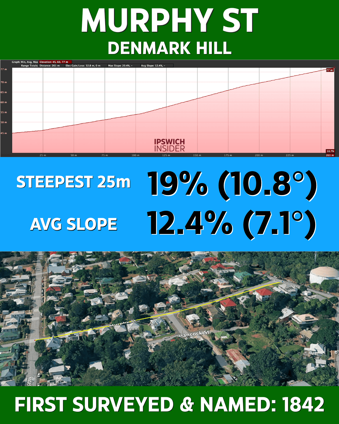
How steep is Murphy Street?
- Steepest 25 m stretch: 18 % (10.2°)
- Average slope over measured distance: 12.4 % (7.1°)
Have a walk up Murphy St
Macrae St, Coalfalls
Have you been up (or down) this road in Coalfalls? It two steep sections before reaching Rowland Terrace. But over the 227 m stretch it was “only” 8.8 % gradient.

How steep is Macrae Street?
- Steepest 25 m stretch: 18 % (10.2°)
- Average slope over measured distance: 8.8 % (5.0°)
Have a walk up Macrae St
Jones St, Blackstone
Did you even know about this steep street leading to the Blackstone water reservoir behind Castle Hill Blackstone Reserve?

How steep is Jones Street?
- Steepest 25 m stretch: 17.2 % (9.8°)
- Average slope over measured distance: 11.7 % (6.7°)
Have a walk up Jones St
Clay St, Denmark Hill
Some swear Clay St is that hardest climb of all the Denmark Hill streets. What do you think?

How steep is Clay Street?
- Steepest 25 m stretch: 16.5 % (9.4°)
- Average slope over measured distance: 11.6 % (6.6°)
Have a walk up Clay St
Stephenson St, Coalfalls
Wow does this road feel steep driving down the north end.
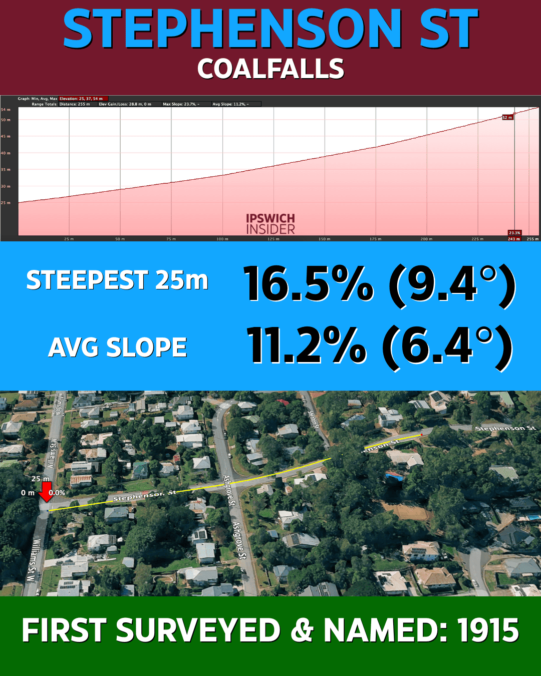
How steep is Stephenson Street?
- Steepest 25 m stretch: 16 % (9.1°)
- Average slope over measured distance: 11.2 % (6.4°)
Have a walk up Stephenson St
Conte Cct, Augustine Heights
This road makes for a great climb. By adjusting your start and end points, you can push its average slope higher than any road on Denmark Hill—though it never quite reaches the same peak steepness.

How steep is Conte Circuit?
- Steepest 25 m stretch: 16 % (9.1°)
- Average slope over measured distance: 12.5 % (7.1°)
Have a walk around Conte Cct.
Panton St, Woodend
I didn’t know about this road before starting this article. Is it a well-known steep road?
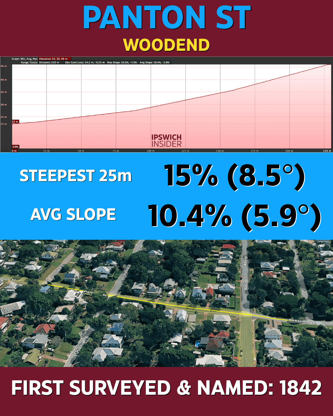
How steep is Panton Street?
- Steepest 25 m stretch: 15 % (8.5°)
- Average slope over measured distance: 10.4 % (5.9°)
Have a walk up Panton St
Winland Dr, Deebing Heights
This Deebing Heights climb rolls up steadily before kicking harder near the top.
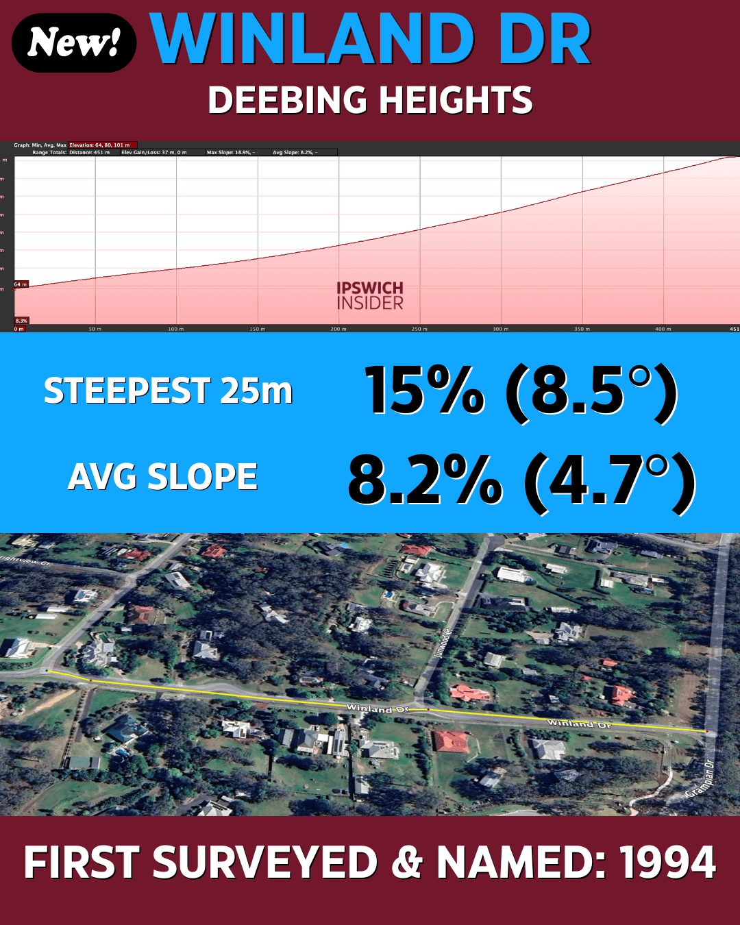
How steep is Winland Drive?
- Steepest 25 m stretch: 15 % (8.5°)
- Average slope over measured distance: 10.4 % (5.9°)
Have a walk up Windland Dr
Nicholas St, Denmark Hill
Had to include this one for comparison to the other Denmark Hill streets.

How steep is Nicholas Street?
- Steepest 25 m stretch: 14 % (8.0°)
- Average slope over measured distance: 8.8 % (5.0°)
Have a walk up Nicholas St
Blakes Rd, Rosewood
A longer rural rise above Rosewood that hides its nasty middle section until you’re on it.

How steep is Blakes Road?
- Steepest 25 m stretch: 14 % (8.0°)
- Average slope over measured distance: 7.3 % (4.2°)
Have a walk up Blakes Rd
Hawthorne St, Coalfalls
Another Coalfalls special, tucked between houses but steep enough to test low gears.

How steep is Hawthorne Street?
- Steepest 25 m stretch: 13 % (7.4°)
- Average slope over measured distance: 7.1 % (4.1°)
Have a walk up Hawthorne St
📏 Road-Geometry Rules of Thumb (QLD / Ipswich)
See Sources Section Below For Links To These Docs
- National baseline — Use the Austroads Guide to Road Design as the starting point.
- State highways (100 km/h) — Sustained grades up to 4 % on flat terrain, 6 % in mountainous areas.
- Urban arterials (80 km/h) — Aim for 5–7 %; exceed only on very short, low-traffic pinches.
- 60 km/h collectors — Desirable 7–9 %; add a climbing lane if > 6 % continues for 300 m.
- Steep-pinch limit — Any stretch > 6 % should be capped at 300 m before relief (lane or crest).
- Local & access streets — 16 % desirable cap; 20 % absolute max, and only for ≤ 60 m bursts.
- Intersections — Through-grade should stay under 4 % so vehicles can stop safely.
- Drainage minimums — Kerb-and-channel needs 0.5 % (0.2 % absolute); rural table drains prefer ≥ 1 %.
- Driveway tie-ins — Verge ≤ 2.5 % and private driveway ≤ 16 % (20 % absolute).
- Vertical curves — On local streets, smooth any grade change > 1 % with a vertical curve.
What do you think?
Will you go have a walk up them all?
Do you want to tell me how wrong the list is and tell me the actual steepest street in Ipswich?
Awesome!
Email me: jamey at ipswichinsider dot com
Sources
- What is the steepest street on Denmark Hill? Facebook.com
- Guide to Road Design Part 3: Geometric Design. austroads.gov.au
- Guide to Road Design Part 4A: Unsignalised and Signalised Intersections. austroads.gov.au
- Road Planning and Design Manual – 2nd Edition. tmr.qld.gov.au
- RPDM Chapter 12: Vertical Alignment (PDF). tmr.qld.gov.au
- FNQROC Development Manual – D1 Road Geometry (PDF). fnqroc.qld.gov.au
- Street Design Manual: Walkable Neighbourhoods (PDF). dsdmipprd.blob.core.windows.net
- Complete Streets: Guidelines for Urban Street Design (PDF). ipwea.com
- Queensland Development Code NMP 1.1 – Driveways (PDF). hpw.qld.gov.au
- Driveways – Ipswich City Council Information. ipswich.qld.gov.au
- QDesign Manual (PDF). hpw.qld.gov.au