
Ipswich Drinking Water Network Tanks at a Glance
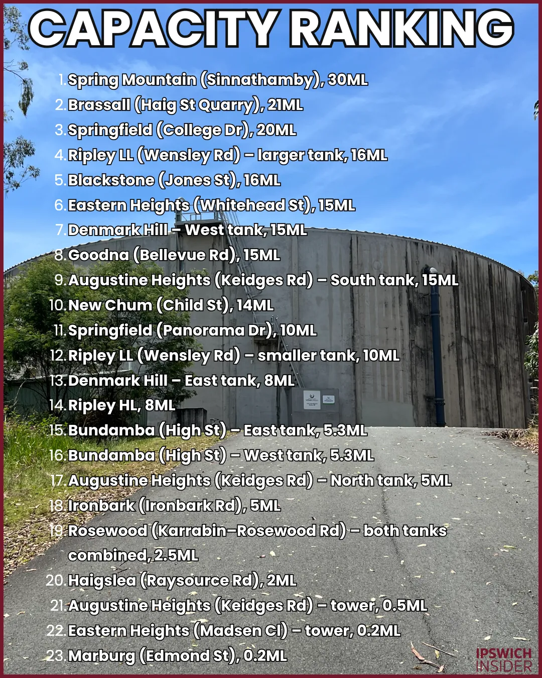
- Hidden storage: Ipswich has ~220 ML of potable water sitting in 23 hilltop tanks, with the biggest single tank at Spring Mountain (30ML).
- Ridge-powered pressure: Every major tank sits on a ridge or high point – Denmark Hill, Blackstone, Scarborough Hill (Bundamba), Keidges Rd, Spring Mountain, Wensley Rd – so gravity does most of the pressure work instead of constant booster pumping.
- Network in transition: Older assets like Ironbark and Rosewood are being reshaped or retired, while new high-level and growth tanks at Ripley, Spring Mountain and (soon) White Rock are taking over as the backbone for Ipswich’s expanding suburbs.

Map showing locations of Ipswich’s 23 operational Urban Utilities water reservoirs.
🔢 By The Numbers

Urban Utilities map showing water reservoir locations across SEQ.
- ~220 ML – Total storage across the 23 hilltop water supply tanks in this guide
- ~60 ML/day – Approximate daily drinking water use across Ipswich
- ~4 days – How long Ipswich could run if every tank here was full
- ~30 ML – Ipswich’s single biggest water tank sits on a ridge North of Spring Mountain and is called SINNATHAMBY by Urban Utilities
- 9,686 km – Length of Urban Utilities’ drinking water mains across its service area
- 116 reservoirs – Service reservoirs operated by Urban Utilities in South East Queensland
- 14,384 km² – Urban Utilities’ total drinking water service area
- ~240 L/day – Average total water use per person per day in Ipswich
- 800 ML/day – Combined maximum output of Mount Crosby East and West Bank treatment plants
- 2.5 ML – Approximate volume of Orion Lagoon at Springfield Central
- $10.3 million – Construction cost of Orion Lagoon
- $12.1 million – Budget for new White Rock 13ML Cumner Rd Reservoir
You know the massive water tanks on hills around Ipswich?
Have you ever wanted to know more about them?
What exactly are they doing, where are they all, and how much water are they storing and moving every day?
Today, let’s find out.
For quick context: Orion Lagoon is ~2.5 ML of water.
Ipswich LGA uses ~60 ML of drinking water every day.
SEQWater produces 800+ ML per day at Mt Crosby East/West Bank. That’s 1x Orion Lagoon worth of water every 4.5 minutes.
Or said another way: ~240 litres per person, per day – showers, toilets, hoses, washing machines and everything else.
To move that water without pumps on every corner, engineers store it up high and let gravity provide pressure.
Every 10 m of height adds 100 kPa pressure at your tap. And most homes run best between 200–500 kPa. That is why Ipswich’s big concrete storage tanks sit on ridges 70 m or more above town. Free pressure thanks to gravity!
Why choose tanks over pumps?
- Free pressure: Gravity supplies most of the 200–500 kPa your house needs, 24/7.
- Emergency buffer: Tanks hold firefighting reserve and keep taps going for hours during power or pump failures.
- Long-term value: Concrete reservoirs can last 80–100 years with periodic rehab. Pump sets need far more frequent replacement and maintenance.
Today we’re looking in-depth at all 23 water tanks across Ipswich. Each has a graphic for you to explore below.
Jump To A Water Reservoir:
Eastern Heights · Denmark Hill · Blackstone · New Chum · Bundamba · Goodna · Augustine Heights · Springfield · Spring Mountain · Ripley · Brassall · Ironbark · Haigslea · Marburg · Rosewood
More Ipswich Gold
Eastern Heights
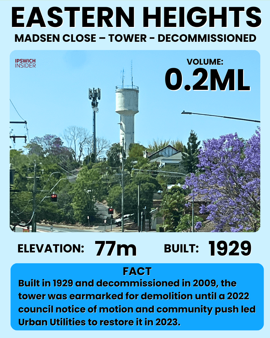
Eastern Heights’ Madsen Close water tower was built in 1929–1930 to help push water up to the suburb’s highest streets, back when tall towers were the easiest way to get pressure. It was decommissioned in 2009, but it still marks the ridgeline.
Details
- Dimensions: Slender elevated standpipe-style tower (much smaller diameter than the ground tanks).
- Volume: 0.2ML.
- Elevation: 77 m above sea level (card value; tower crest sits higher again).
- Built: 1929–1930.
- Purpose: Water storage + pressure for higher streets in Eastern Heights (original high-level zone).
- Cool fact: Decommissioned in 2009 after about 80 years of service, then restored and kept as a local landmark.
- Notes: No public capacity figure; treated here as a historic pressure asset rather than a major ML storage pool.

The Whitehead Street reservoir (built 1961) is the modern workhorse for Eastern Heights, storing far more water than the old tower ever could. Sitting on the ridge overlooking Limestone park, it feeds the suburb by gravity and steadies pressure when everyone is showering, washing, and watering at the same time.
Details
- Dimensions: Approx. 40 m diameter × 12 m high.
- Volume: ~15 ML.
- Elevation: 77 m above sea level.
- Built: 1961.
- Purpose: Water storage + pressure for Eastern Heights and nearby suburbs.
- Cool fact: Sits on the ridge between Fairy Knoll and Karragarro, effectively blocking the two hilltops from ever seeing each other.
- Notes: Volume from simple cylinder geometry; operating volume is slightly lower due to freeboard and operating set-points.
Denmark Hill – Ipswich Central

Denmark Hill’s east tank was built in 1928 as a major leap forward for Ipswich’s drinking water reliability, giving the CBD a big, steady “buffer” of water at height. From here, gravity could do most of the work, keeping pressure up while the wider network refilled the hilltop storage in the background.
Details
- Dimensions: Approx. 30 m diameter × 12 m wall height with a domed concrete roof.
- Volume: ~8 ML (cylinder plus some dome volume).
- Elevation: 78 m above sea level.
- Built: 1928.
- Purpose: Water storage + pressure for central Ipswich.
- Cool fact: Camouflaged during World War II and once promoted as one of the largest reinforced concrete reservoirs in the British Empire.
- Notes: Dome volume partly counted; true working volume depends on SCADA operating levels, which sit below the very top of the dome.

As Ipswich grew, a second Denmark Hill tank was added in the 1960s to lift storage capacity and add redundancy on the city’s main ridge. Two tanks on the same hill means the network can keep supplying Ipswich even when one tank needs maintenance or cleaning.
Details
- Dimensions: Approx. 40 m diameter × 12.5 m high (from the level gauge).
- Volume: ~15 ML.
- Elevation: 77 m above sea level.
- Built: 1960s.
- Purpose: Extra water storage + pressure stability for Ipswich CBD as demand grew beyond the 1928 tank.
- Cool fact: With two tanks on one hilltop, Denmark Hill has been Ipswich’s “water crown” for nearly a century.
- Notes: Volume from geometry using the 12.5 m gauge height; decade from local-history references rather than a single documented commissioning year.
Blackstone
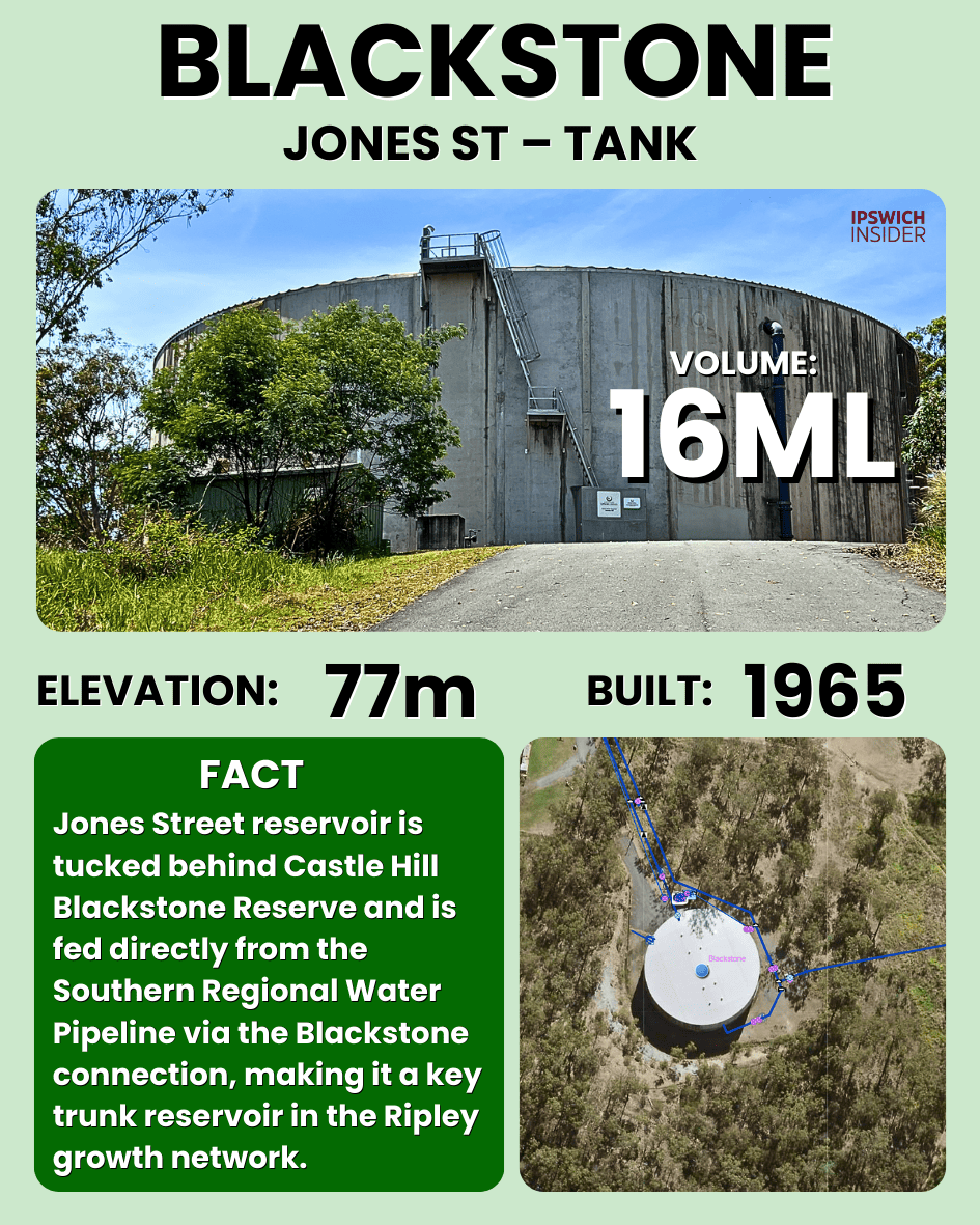
Blackstone’s Jones Street reservoir was built in the mid-1960s to serve the growing southern suburbs of Ipswich – Flinders View, Raceview and Ripley Valley. Its job is simple but vital, store treated water on high ground so gravity can hold steady pressure across Blackstone and nearby suburbs.
Details
- Dimensions: Approx. 42 m diameter × 12 m high.
- Volume: ~16 ML.
- Elevation: 77 m above sea level.
- Built: Approx. 1960s (often cited as 1965).
- Purpose: Water storage + pressure for Blackstone and nearby hill suburbs.
- Cool fact: Its siting on Blackstone Hill lets it push water in multiple directions by gravity with minimal booster pumping.
- Notes: Volume from geometric estimate; decade inferred from network expansion and local development era.
New Chum

The Child Street reservoir is one of the newer pieces in Ipswich’s network, built as the Riverview and New Chum area expanded. It acts like a local battery, smoothing out demand spikes and keeping pressure steady while trunk mains and pumps top it back up.
Details
- Dimensions: Approx. 40 m diameter × 11 m high.
- Volume: ~14 ML.
- Elevation: 79 m above sea level.
- Built: Approx. 2000s.
- Purpose: Water storage + pressure for the Riverview / New Chum pocket.
- Cool fact: Quietly sits between residential and industrial land, smoothing out both household and industrial demand spikes on the same trunk corridor.
- Notes: Built decade inferred from aerial imagery and estate timing; ML from geometry.
Bundamba – High Street Twin Tanks
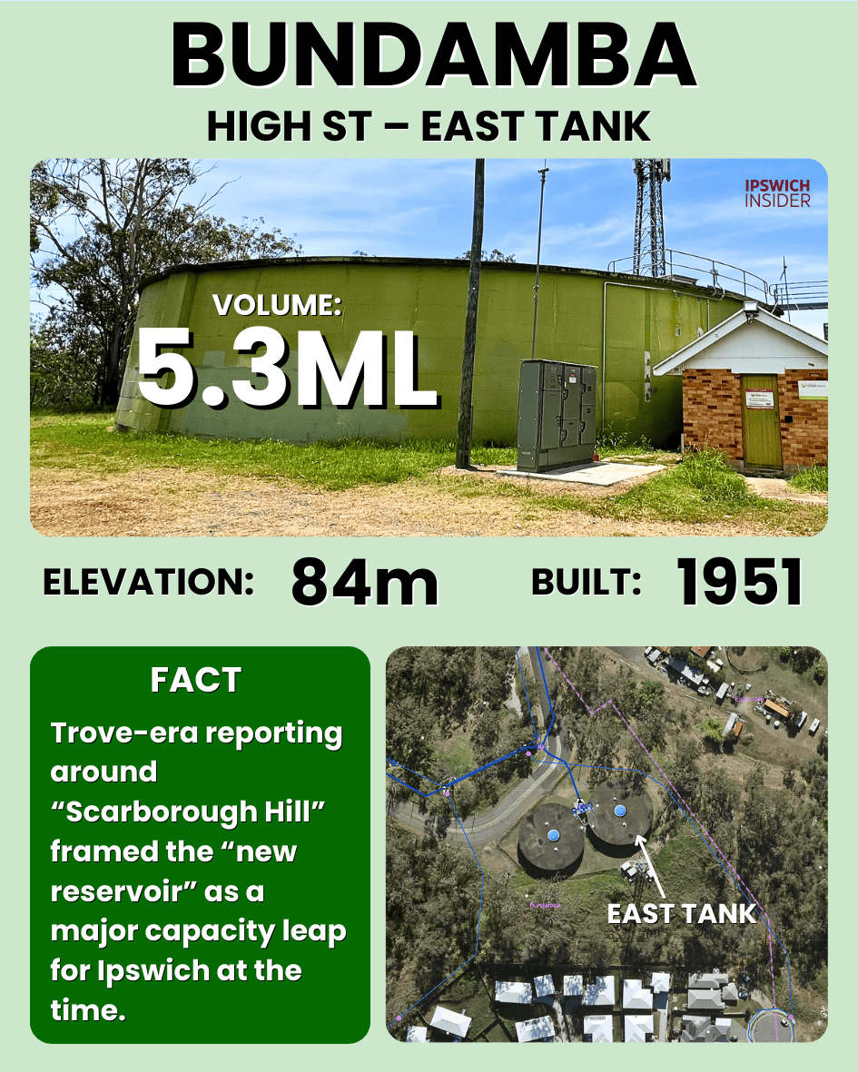
Bundamba’s High Street tanks were built in the early 1950s on what was once called Scarborough Hill to strengthen Ipswich’s eastern drinking-water supply. The site is partly bermed into the hill, but its role is big, it stores water at height so Bundamba and surrounds can run on gravity pressure even during peak demand.
Details
- Dimensions: Approx. 30 m diameter; ~5 m wall visible, with additional height likely below ground.
- Volume: ~5.3 ML (assumed half of ~10.6 ML site total).
- Elevation: 84 m above sea level.
- Built: Early 1950s (approx. 1951).
- Purpose: Water storage + pressure for Bundamba and part of the eastern network.
- Cool fact: When the “Scarborough Hill” reservoir first came online it was hailed as almost doubling Ipswich’s storage capacity.
- Notes: Depth back-calculated from 10.6 ML site total. Berming hides part of the wall, so only ~5 m is visible from the road.
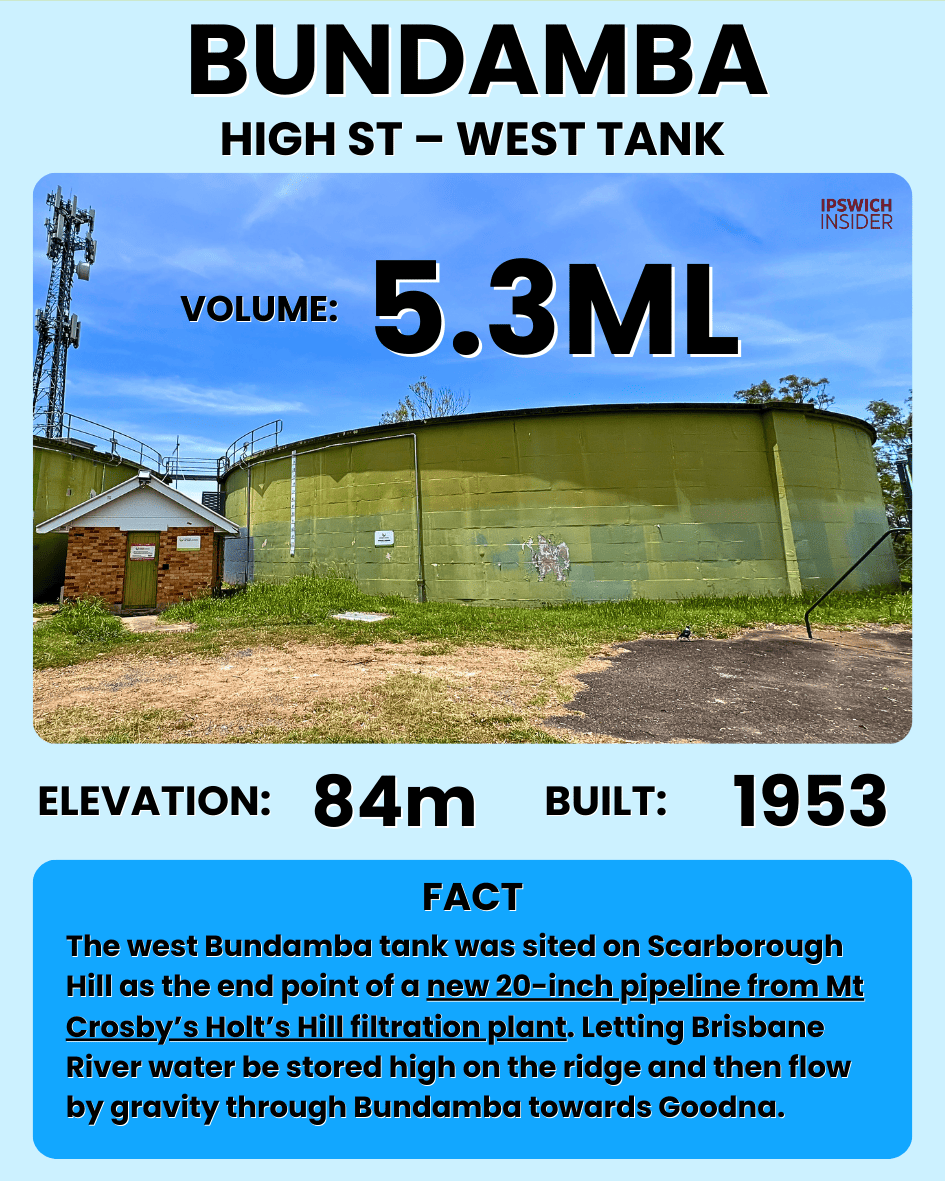
The west tank is the partner to the east tank, giving Bundamba backup storage and more operational flexibility. Having two tanks on one hilltop also helps the wider network ride through outages or planned works without the suburb running low straight away.
Details
- Dimensions: Approx. 30 m diameter; similar visible height to the east tank.
- Volume: ~5.3 ML (paired to make ~10.6 ML total).
- Elevation: 84 m above sea level.
- Built: Early 1950s (approx. 1953).
- Purpose: Extra storage + redundancy; lets Urban Utilities take one tank offline while the other keeps feeding the zone.
- Cool fact: The “reverse” level board reads from the roof down, showing how far below full the water level is rather than depth from the floor.
Goodna
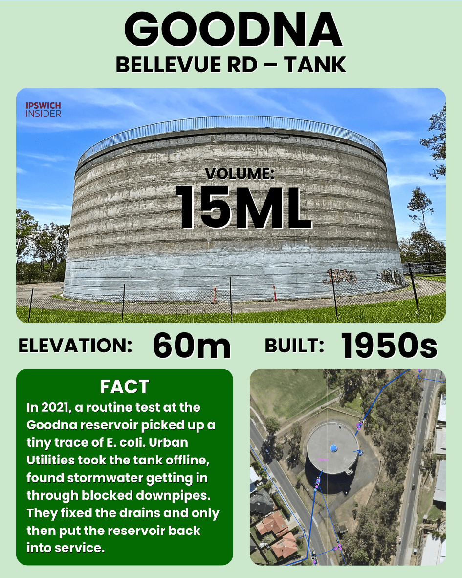
Goodna’s Bellevue Road reservoir is part of the older “river suburbs” supply story, storing water above the floodplain so pressure stays consistent down on the flats. It buffers daily peaks and helps stabilise the long mains that feed the Goodna area.
Details
- Dimensions: Approx. 40 m diameter × 12 m high.
- Volume: ~15 ML.
- Elevation: 60 m above sea level.
- Built: Approx. 1950s.
- Purpose: Water storage + pressure for Goodna and surrounding low-to-mid elevation streets.
- Cool fact: Sits above the old highway corridor, acting as the “buffer bowl” between trunk mains and a mix of older housing and industry.
- Notes: Volume from geometry; decade inferred from housing era and overall network development timeline.
Augustine Heights
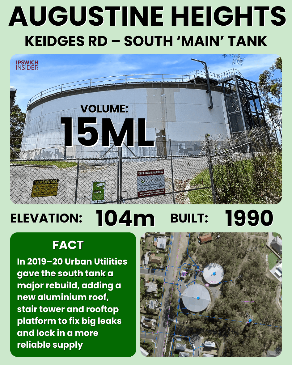
The Keidges Road south tank (built 1990) is the main storage bowl for Augustine Heights, Redbank Plains, South Ripley and White Rock. From this ridge, the network can feed lower streets by gravity and support higher zones through the nearby tower and companion tank.
Details
- Dimensions: Approx. 47 m diameter × 10 m high.
- Volume: ~15 ML (geometry; treated as a 15–17 ML class tank).
- Elevation: 104 m above sea level.
- Built: 1990.
- Purpose: Water storage + pressure for Augustine Heights / Redbank Plains low-level zone.
- Cool fact: Anchors a three-structure Keidges Rd complex (two tanks plus a tower) that serves both low- and high-level areas off the same ridge.
- Notes: Volume rounded; capacity sits in the 15–17 ML range depending on exact wall thickness and operating band.
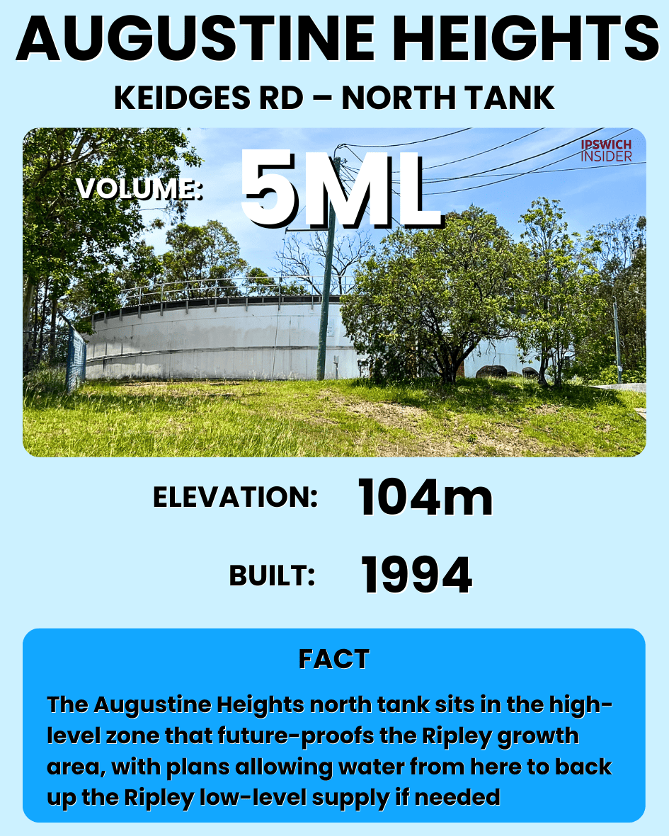
The north tank is the Keidges Road expansion piece, added in the 1990s as housing and demand climbed. It boosts total storage and gives extra redundancy so the area can keep pressure steady during outages or maintenance.
Details
- Dimensions: Approx. 35 m diameter × 5 m visible (likely deeper where bermed).
- Volume: ~5 ML (minimum based on visible wall).
- Elevation: 104 m above sea level.
- Built: 1994.
- Purpose: Additional storage + redundancy for the same Keidges Rd zone.
- Cool fact: Smaller expansion tanks like this typically show up when real demand outstrips the original single-tank forecast.
- Notes: True water depth may exceed 5 m; volumes will increase if more of the wall is below grade.
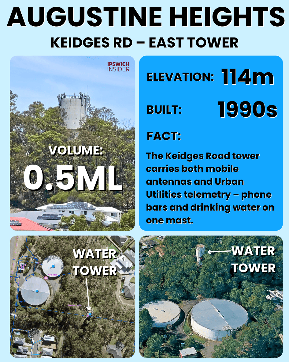
The Keidges Road tower is all about height, it provides extra head pressure to homes that sit above the reach of the ground tanks. It works like a vertical shortcut for pressure in the high-level zone while the bigger tanks do the bulk storage job.
Details
- Dimensions: Slender elevated tower (smaller diameter, tall shaft).
- Volume: Small ~0.5ML.
- Elevation: 114 m above sea level.
- Built: Approx. early–mid 1990s.
- Purpose: Water storage + pressure for the Keidges Rd high-level zone (streets above what the ground tanks can serve by gravity alone).
- Cool fact: It’s the high point of a stacked system – two ground tanks and a tower – all on one ridge to serve different elevation bands.
- Notes: Included for network context; no ML value added to the main “big bowl” totals.
Springfield

Springfield’s College Drive reservoir is the main storage anchor for the suburb’s primary pressure zone, built for a master-planned city that needed dependable supply from day one. It stores a large buffer of treated water so gravity can feed thousands of homes while the wider network refills the tank between peaks.
Details
- Dimensions: Approx. 48–50 m diameter × ~11 m deep.
- Volume: ~20 ML.
- Elevation: 107 m above sea level.
- Built: Late 1990s.
- Purpose: Water storage + pressure for Springfield’s main residential zone.
- Cool fact: Already had a major roof and access rehab, which is how a 1990s tank keeps up with 2020s suburb-growth loads.
- Notes: Volume matches the 20 ML design class; geometric calculation and planning docs line up here.

The Panorama Drive reservoir serves Camira and Carole Park as well as parts of Springfield where it sits. Its “tucked into the hill” setup is common in newer suburbs, the tank still does the same job, but the earthworks help it blend in and protect the structure.
Details
- Dimensions: Approx. 48 m diameter × ~5 m visible (likely more below grade).
- Volume: ~10 ML based on visible wall.
- Elevation: 93 m above sea level.
- Built: Approx. 2000s.
- Purpose: Water storage + pressure for the Panorama Drive band of Springfield.
- Cool fact: A named trunk main from WP054 to “Panorama Drive Reservoir R072” makes this tank a formal node in the Springfield backbone, not just a simple storage stub.
- Notes: Berming likely hides extra wall; 9 ML is a conservative lower bound.
Spring Mountain
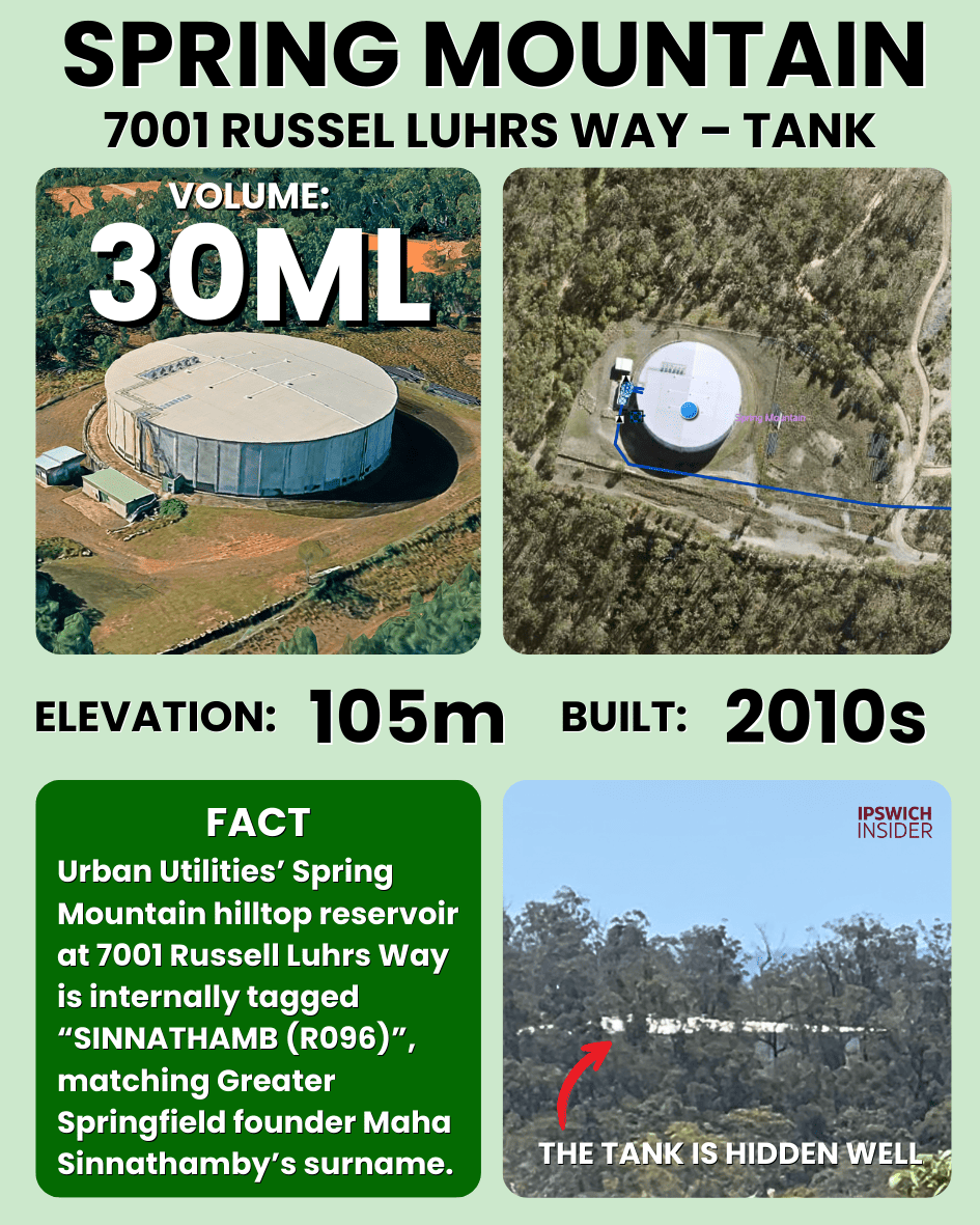
The Spring Mountain reservoir is the modern mega-tank for Ipswich’s fastest-growing corridor, storing a huge buffer of drinking water high above the estates below. It lets whole suburbs run on gravity pressure while pumps and trunk mains quietly refill the storage between peaks. This tank is huge!
Details
- Dimensions: Approx. 60 m diameter × 12 m high.
- Volume: ~33 ML (likely nominal 30 ML class).
- Elevation: 105 m above sea level.
- Built: Approx. 2010s.
- Purpose: Water storage + pressure for Spring Mountain / Springfield Rise growth area.
- Cool fact: Probably the biggest single “hilltop bowl” in the Ipswich potable network, built to keep up with the fastest-growing estates in the city.
- Notes: Volume from geometric estimate; planning text references a Springfield 30 ML reservoir that matches this site.
Ripley

Ripley’s high-level reservoir is the uphill partner to the Wensley Road site, feeding Deebing Heights estates that sit well above the valley floor.
Details
- Dimensions: Roof diameter not re-measured; capacity from planning/GIS.
- Volume: 8 ML.
- Elevation: 150 m above sea level.
- Built: Approx. 1987.
- Purpose: Water storage + pressure for the Ripley high-level zone (higher ground estates).
- Cool fact: Without this HL storage, much of the upland side of Ripley/Deebing would need far more mechanical boosting to meet minimum pressure standards.
- Notes: Capacity taken directly from planning; geometric volume not recomputed here.
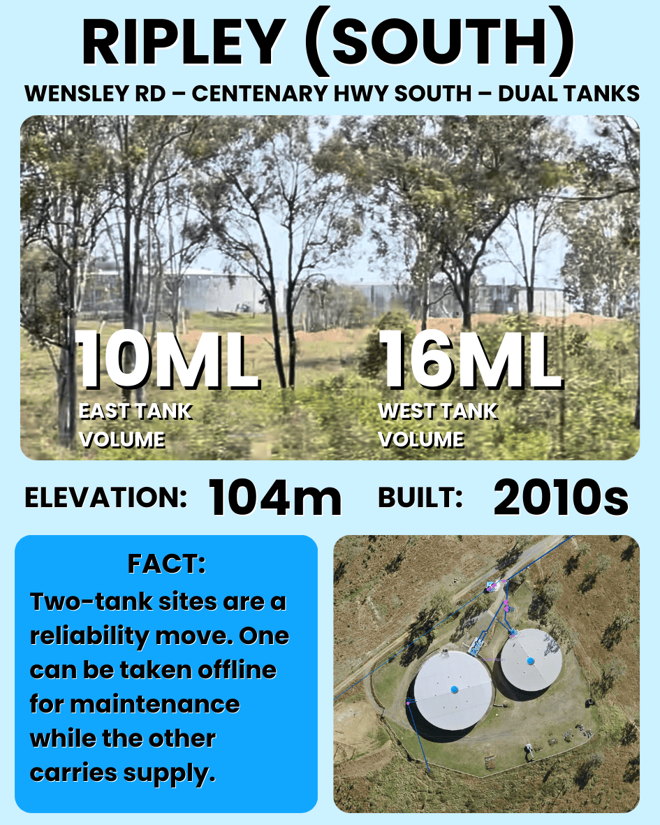
The Wensley Road tanks are the main low-level storage for Ripley West, a two-tank site sized for a whole new corridor of housing. Being close to the highway is not an accident, it keeps the storage near trunk mains and lets gravity feed the broad, flatter parts of the planned Ripley Valley Priority Development Area.
Details
- Dimensions: Larger LL tank ~54 m diameter; smaller LL tank ~42 m diameter (heights inferred).
- Volume: ~26 ML total (split here as ~16 ML + ~10 ML).
- Elevation: 104 m above sea level.
- Built: Approx. 2010s.
- Purpose: Water storage + pressure for the Ripley West low-level zone.
- Cool fact: This pair is one of the few sites where your tank volumes line up with explicit council wording about “26 ML of low-level storage at Wensley Road”.
- Notes: Heights and ML split chosen to honour your 26 ML total; a level-board read in person would refine each tank’s exact depth.
Brassall
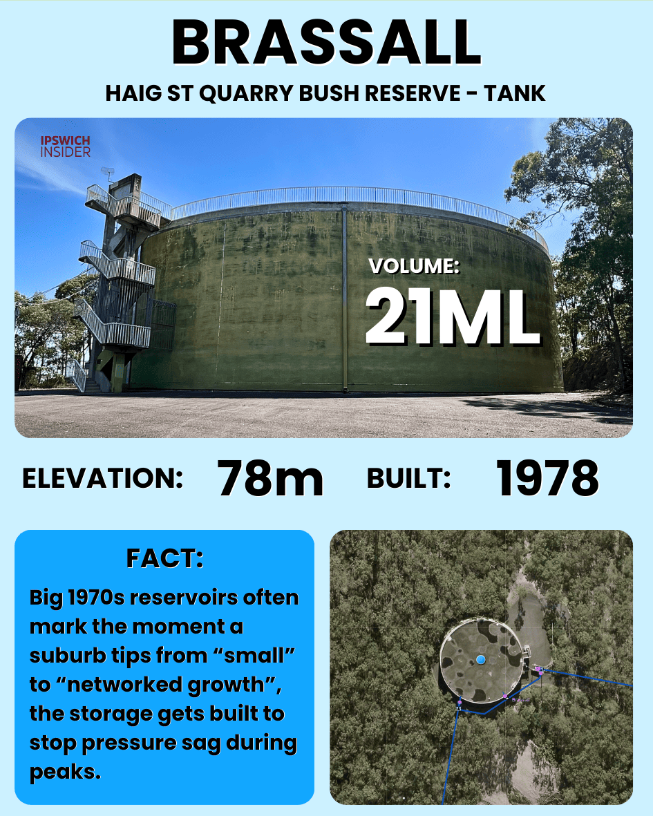
Brassall’s quarry-side reservoir (1978) is a northern powerhouse, storing a large volume above the suburb so gravity can feed Brassall and beyond. It is a classic suburban-growth tank from the late 1970s, built to keep pressure stable as the north side expanded.
Details
- Dimensions: Approx. 47 m diameter × 12 m high.
- Volume: ~21 ML.
- Elevation: 78 m above sea level.
- Built: 1978.
- Purpose: Water storage + pressure for Brassall and surrounding suburbs.
- Cool fact: Continues to show up in long-range upgrade plans, which means it remains a backbone asset even decades after commissioning.
- Notes: Volume rounded from geometry; build year tied to documented commissioning period.
Ironbark

Ironbark’s reservoir serves Ipswich’s rural western fringe, a smaller hilltop tank that still relies on the same physics as the big suburb bowls, height equals pressure. It is also one of the few Ipswich tanks flagged for future decommissioning as the network continues to evolve.
Details
- Dimensions: Approx. 37 m diameter × 5 m high.
- Volume: ~5 ML.
- Elevation: 125 m above sea level.
- Built: Approx. 1970s–1980s.
- Purpose: Water storage + pressure for the Ironbark / rural west pocket.
- Cool fact: One of the only Ipswich tanks explicitly listed for decommissioning in Urban Utilities’ Netserv schedule.
- Notes: Once removed, its role will be picked up by other storages and mains; ML rounded from geometry.
Haigslea

Haigslea’s Raysource Road reservoir is a small but strategic rural tank, holding storage high up to stabilise pressure at the end of long mains. It also sits on a corridor where major future upgrades are planned, linking western towns into the wider Ipswich network.
Details
- Dimensions: Approx. 20 m diameter × 5–6 m high.
- Volume: ~2 ML.
- Elevation: 133 m above sea level.
- Built: Approx. 1960s.
- Purpose: Water storage + pressure for Haigslea and nearby rural customers.
- Cool fact: A future 5.77 km trunk main from Haigslea to Marburg highlights this “small” site as the hinge point of the western rural corridor.
- Notes: The 0.6 ML seen in Netserv is likely a planning/usable band; the physical tank, using your dimensions, is closer to 2 ML.
Marburg

Marburg’s Edmond Street reservoir is tiny compared with Ipswich’s city tanks, but it plays the same role locally, it is the buffer that keeps pressure steady in town. Small reservoirs like this are how outlying communities get reliable mains water at the far end of long supply lines. It sits on the hill behind the Marburg Rural Fire Brigade building.
Details
- Dimensions: Approx. 11 m diameter × 2.5 m high.
- Volume: ~0.2 ML.
- Elevation: 124 m above sea level.
- Built: Approx. 1970s.
- Purpose: Small storage + pressure buffer for Marburg township.
- Cool fact: Marburg only moved toward a town water supply after a 1950 public meeting voted 4–3 in favour – this little tank is part of the legacy of that extremely close decision.
- Notes: Height assumed; Netserv’s Haigslea–Marburg trunk main confirms this as the local node for town supply, even if the tank itself is modest.
Rosewood

Rosewood’s Karrabin–Rosewood Road site is a two-tank setup that underpins the township’s pressure and firefighting reserve. Even small-town reservoirs become key nodes once you are at the end of long pipelines, they give the network a local “battery” instead of relying on live flow alone.
Details
- Dimensions: North tank ~25 m diameter × ~3 m visible; south tank ~20 m diameter × ~3 m visible.
- Volume: Combined ~2–3 ML (close to the 2.5 ML program figure).
- Elevation: 101 m above sea level.
- Built: Approx. 1970s.
- Purpose: Water storage + pressure for Rosewood and nearby rural areas.
- Cool fact: Long-range plans include a 4.6 km upgrade main along Karrabin–Rosewood Rd, showing this little two-tank site matters far beyond town boundaries.
- Notes: Depth below grade unknown; volumes are geometric estimates tuned to match the 2.5 ML headline capacity.
How Ipswich’s Water Supply Tanks Are Designed and Built
Basics
- Circular concrete cylinders: Cylinders spread water pressure evenly around the wall, so you don’t get weak corners. Reinforced or post-tensioned concrete handles long-term loads and is fire-proof.
- On hilltops: Height equals pressure. Gravity does the work for you.
- Roofed and fenced: Roofs keep sunlight, debris and wildlife out, and reduce chlorine loss and temperature swings.
Design
- Volume (ML): Start with peak day demand for the zone, add firefighting allowance and some outage buffer. That gives a target like “this zone needs roughly 10–20 ML of storage”.
- Diameter vs height: A bigger diameter and lower wall gives a wide, stable tank. A smaller diameter and taller wall saves footprint but increases stresses. Most ground reservoirs here end up in the 30–60 m diameter and 8–12 m water depth range.
- Top Water Level (TWL): Pressure at a house ≈ height difference between TWL and the tap × ~10 kPa per metre, minus friction. Utilities pick a TWL that gives enough pressure to the highest houses without over-pressuring the lowest ones.
Build
1. Site and pad: Survey the ridge, pick a spot where you can carve a flat circle 70–80 m across. Geotech checks for soil/rock strength and any legacy mine workings.
2. Earthworks: Cut and fill a level bench into the hill. Build drainage so stormwater doesn’t scour the pad.
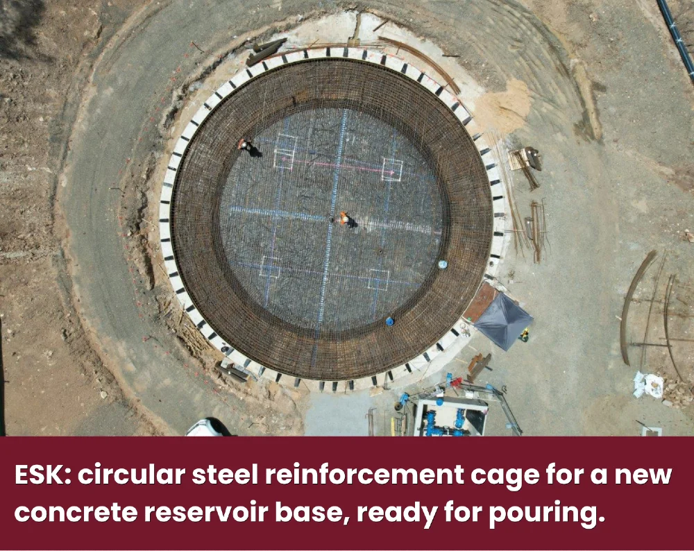
Source: Urban Utilities Esk Reservoir Build
3. Base and walls: Pour a thick circular base slab with heavy reinforcement. Cast circular walls (often in segments) with lots of reinforcement or circumferential post-tensioning to resist water pressure.
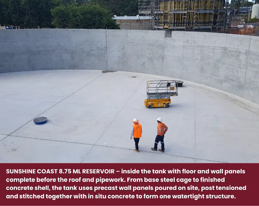
Source: Albatross Avenue Reservoir
4. Roof and access: Older tanks use domed concrete roofs (Denmark Hill east). Newer ones often use flat or low-pitch concrete or aluminium roofs supported on internal columns or beams, with ladders, handrails and hatches added for safe access.
5. Pipework and fittings: Add inlet and outlet mains, bypass line, overflow, scour, air valves, vents, level gauges, and telemetry so SCADA can monitor and control the tank.
Connection
Buried trunk mains:
Each tank is tied into larger pipes (often 300–600 mm) that can run 100s or 1,000s of metres along roads like Wensley Rd, Keidges Rd, Old Logan Rd or Mount Juillerat Dr.
Pumps and zones:
Treatment plants and large pump stations push water up into reservoirs. The reservoirs then gravity-feed their “pressure zone”. High-level (HL) tanks like Ripley HL serve higher ground, low-level (LL) tanks like Wensley Rd LL serve lower ground.
Redundancy and loops:
Twin tanks (Bundamba, Ripley LL) and multiple interlinked reservoirs (Keidges + tower, Denmark Hill + Brassall + Bundamba) create loops, so one asset can be taken offline without cutting water to whole suburbs.
🚰 Our SEQ Circle of Water
- Rain in the catchment: Rain falls on the Upper Brisbane River catchment and runs into creeks and rivers feeding Wivenhoe Dam.
- Stored in Wivenhoe: Wivenhoe Dam holds the raw water “bank” for Brisbane and Ipswich, smoothing out floods and droughts.
- Drawn at Mt Crosby: Water is released down the Brisbane River and pumped up from Mt Crosby Weir into the treatment plants.
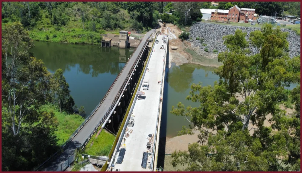
Mt Crosby Weir Bridge 2024 (Source: SEQ Water)
- Cleaned at the plant: Coagulant is added, dirt and bugs are settled and filtered out, then the water is disinfected and fluoridated.
- Into the SEQ Water Grid: Treated drinking water flows into big bulk mains that move it around South East Queensland.
- Handed to Urban Utilities: Urban Utilities takes the treated water at offtakes and pumps it up to Ipswich’s hilltop tanks.
- Gravity to your street: From each tank, gravity pushes water down through local mains, past your meter and out of your tap.
Sources
- Urban Utilities Open Data GIS Map. ArcGis.com.
- Asset GIS Information. UrbanUtilities.com.au.
- Water Netserv Plan (overview and documents). UrbanUtilities.com.au.
- Water Netserv Plan Part A (Ipswich water supply schedule of works). UrbanUtilities.com.au.
- Whitehead Street Reservoir Upgrade (Eastern Heights project). UrbanUtilities.com.au.