
Ipswich Aerial Archives Edition #01 at a Glance
- Locations: Today we zoom in to Ipswich Central, Redbank, Swanbank, RAAF Amberley, Willowbank Motorsport Precinct and Mt Marrow Quarry.
- Images: 33 dated aerial images in this edition. © State of Queensland (Queensland Government). Aerial imagery sourced via Queensland Globe and QImagery. The year shown is the imagery layer year and may not always match the exact capture date.
- Markup: Arrows and labels added by Ipswich Insider to help you spot key changes. The underlying aerial imagery is unchanged.
🔢 By The Numbers
- 38,940 people Ipswich (town) population in the 1954 Census,
- 50 hectares Limestone Park size
- 5,000+ people employed at RAAF Base Amberley, one of Ipswich’s largest single-site workforces
- 2,503 hectares RAAF Amberley base + buffer footprint, bigger than many Ipswich suburbs
- $1.2 billion projected lift to Queensland’s economy from Amberley-related investment
- 100,000+ spectators hosted each year at Willowbank Raceway
- 811 ML Swanbank Cooling Water Dam capacity, about 324 Olympic pools
- 600,000 homes Swanbank B “enough electricity to power” benchmark (historic coal era)
- 1,000,000 tonnes black coal used per year at Swanbank B (historic coal era)
- $330 million Swanbank Battery project value (250MW / 500MWh build)
- 700,000 parcels/day peak throughput at Australia Post’s Redbank parcel hub
- 4,000,000 cases/week Coles Redbank ADC processing at full capacity
- $170 million Rheinmetall MILVEHCOE build value (11ha site; 30,000 m² production building; 100m firing tunnel)
- 77,100 m² Officeworks omnichannel DC at Redbank Motorway Estate will be a top 10 DC Australia-wide
- 35 trucks/day Mt Marrow haulage throughput
This is Ipswich Aerial Archives – Edition #01: a simple “then vs now” time-travel set using official Queensland Government aerial imagery, stitched into one scroll.
We zoom in on 6 places that tell big Ipswich stories from above: Ipswich Central, Redbank, Swanbank, RAAF Amberley, Willowbank Motorsport Precinct, and Mt Marrow Quarry.
Each section starts with a quick overview card, then the aerials run oldest to newest. The fun is spotting what changes first in each location: new roads, new roofs, cleared pads, shifting river edges, rail yards, pits, dams, and carparks.
Use the Jump to location box to skip around, or read it straight through and watch Ipswich “build itself” one precinct at a time.
Jump to location
More Ipswich Gold
All aerial images are © State of Queensland, sourced via Queensland Globe and QImagery.
Ipswich Central

Ipswich Central Historic Overview
- START: Ipswich’s centre takes shape as a river town from the 1840s, with the CBD grid forming around the Bremer River and later rail links.
- WHY HERE: A natural transport and trade point on the Bremer, linking Brisbane to inland districts. Early resources like limestone and coal helped drive growth.
- FIRST PURPOSE: River-port service town and regional trade centre, then a rail-and-industry city as workshops, yards and factories expanded.
- AERIAL TELLS: Tight CBD street grid, bridges across the Bremer, Queens Park as a fixed green block, and rail and industrial footprints nearby.
- NOW: Ipswich’s civic and heritage core, with Queens Park and the river corridor still shaping “central Ipswich” from above.
1955 – Ipswich Central
Post-war Ipswich reads as a compact centre anchored to the Bremer River. The CBD grid is tight, Queens Park and Limestone Park are already large established green blocks. And nearby rail infrastructure stands out as a key organising feature. Beyond the centre, most development is still lower-density with plenty of open land at the edges. Notice an empty Moore’s Pocket in the top right of this image.

The big oval in the middle of Limestone Park is earthworks underway for the news sports oval.
1978 – Ipswich Central
Between 1955 and 1978, Ipswich spreads. You can especially see more houses in Eastern Heights, Raceview and Silkstone in this image. The centre stays anchored to the river, and you can see the new (1965) David Trumpy Bridge appear. Denmark Hill, Queens Park and Limestone Park remain the fixed landmarks while the urban fabric thickens around it.
1987 – Ipswich Central
Between 1978 and 1987, the inner area looks more car-oriented. Sealed roads and parking areas become more obvious, and the commercial footprint around the CBD edges looks heavier. Residential infill continues in surrounding neighbourhoods.
1997 – Ipswich Central
Between 1987 and 1997, Ipswich’s footprint continues to grow and the transition from CBD to suburb looks less abrupt. More land is taken up by commercial and industrial hardstand near major routes, and suburban growth fills gaps around older neighbourhoods. The CBD grid strengthens and the wider city looks more connected and built out.

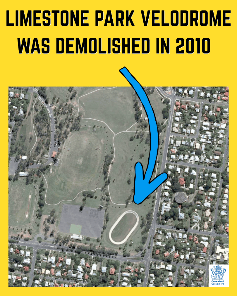
Limestone Park Velodrome
Due to safety concerns the Limestone Park velodrome was demolished in 2010. It is now an overflow grass car park for the netball events.
2010 – Ipswich Central
Between 1997 and 2010, central Ipswich shows more modern redevelopment patterns. Including Riverlink Shopping Centre on the North shore of the Bremer. Larger roofs, upgraded road layouts and more consolidated commercial areas become clearer. Green space remains a constant, while the river and transport corridors continue to guide where higher-intensity development lands. The park blocks still act as visual anchors in the middle of the city.

Redbank

Redbank Historic Overview
- START: Redbank’s modern footprint is shaped by the rail corridor, with major workshop construction visible in the 1950s and operations established by the late 1950s.
- WHY HERE: Flat land beside the Brisbane to Ipswich rail line, later paired with strong motorway access that suits heavy industry and logistics.
- FIRST PURPOSE: Rail maintenance and industrial activity centred on workshops, yards and supporting infrastructure.
- AERIAL TELLS: Long workshop sheds, sidings and yard geometry first, then later large-format warehouses, estate roads and extensive hardstand.
- NOW: A major industrial and logistics precinct layered over an older rail-and-industry landscape.
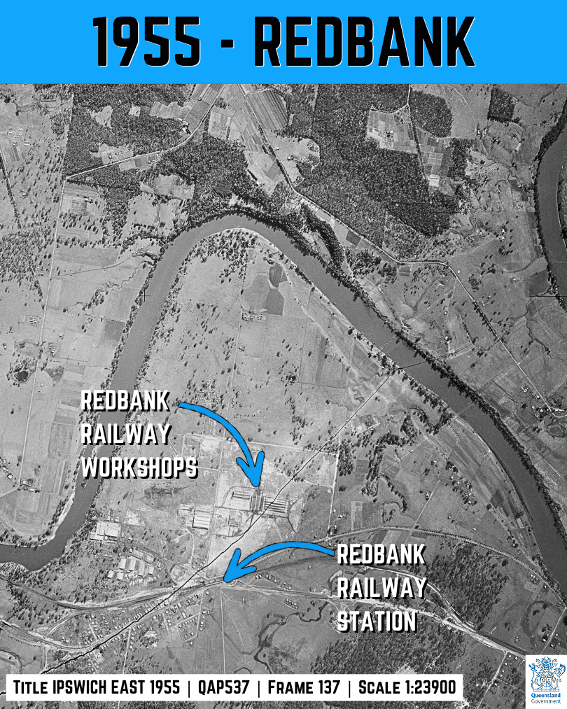
1955 – Redbank
In 1955, the rail corridor is already the dominant feature, and the Redbank workshop footprint is visible as a major industrial build. Long roofs and yard geometry stand out against surrounding open land. This reads as a place being purpose-built for heavy rail activity, before the later wave of motorway-era warehousing takes over the wider landscape.
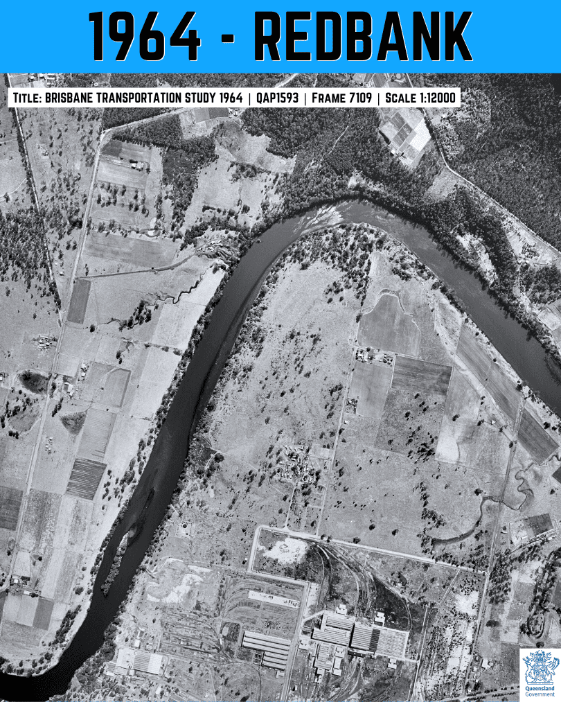
1964 – Redbank
Between 1955 and 1964, the rail and workshop precinct consolidates. Buildings and hardstand look more complete, and the yard layout is clearer and more extensive. The industrial cluster sits tightly to the rail spine.
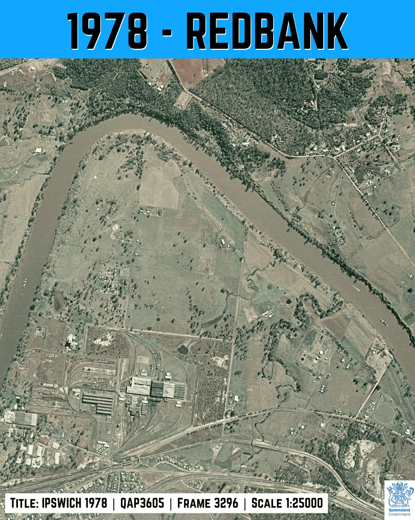
1978 – Redbank
Between 1964 and 1978, the workshops and yards look mature and heavily used. Sealed surfaces and supporting sheds increase, and the broader setting shifts from semi-rural to a mix of suburb and industry. This is the established rail-workshop era, where the main story is operational consolidation rather than brand-new precinct layout.
2002 – Redbank
Between 1978 and 2002, Redbank’s industrial footprint spreads beyond the rail core. Redbank Plaza opens in 1985. Roads and larger lots become more influential alongside rail, and open land fragments into more defined industrial parcels. This period is the bridge between the traditional rail-workshop landscape and the modern logistics estate pattern that becomes dominant in later years.

2025 – Redbank Motorway Estate
Between 2002 and 2025, Redbank reads as fully modern industrial and logistics land. Big-box warehouses and distribution centres, internal estate roads and large hardstand areas dominate. The older rail backbone is still present although mostly disassembled. It is now a much larger motorway-oriented industrial landscape. From above, the scale shift is obvious and permanent.

Swanbank

Swanbank Historic Overview
- START: Swanbank shifts from rural and mining-era land use into a major industrial build in the early 1960s, with coal power generation established soon after.
- WHY HERE: A large, empty site near local coal resources with room for heavy industry, coal handling, ash infrastructure and staged expansion away from dense housing.
- FIRST PURPOSE: Coal-fired electricity generation to supply South East Queensland’s growing demand.
- AERIAL TELLS: Rapid clearing and pad construction, then large plant buildings, stacks, engineered water and ash areas, and an expanding industrial road network.
- NOW: An energy and industry corridor that has evolved from one dominant coal-era footprint into a broader precinct with multiple large uses.
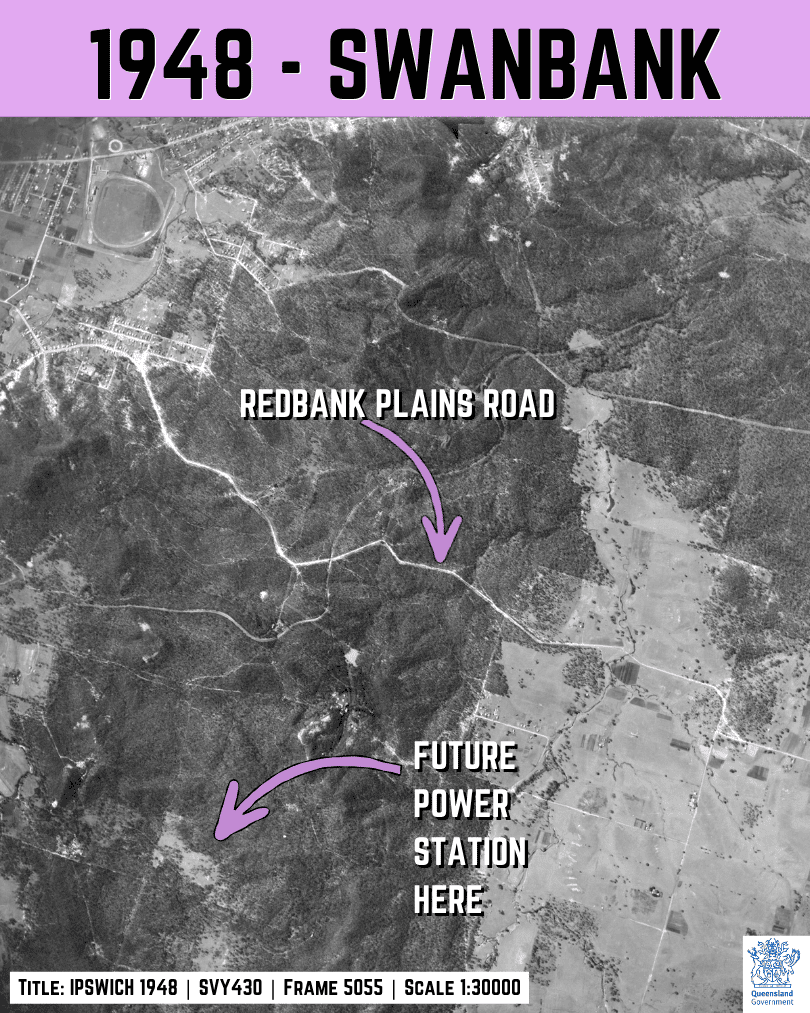
1948 – Swanbank
In 1948, this is a rural and mining-era landscape. There are open paddocks, scattered buildings and disturbed ground, but nothing like the later power station footprint. Roads like Redbank Plains Road are the clear organising lines. This frame works as the “before” shot, showing how empty the site was before industrial development arrives.
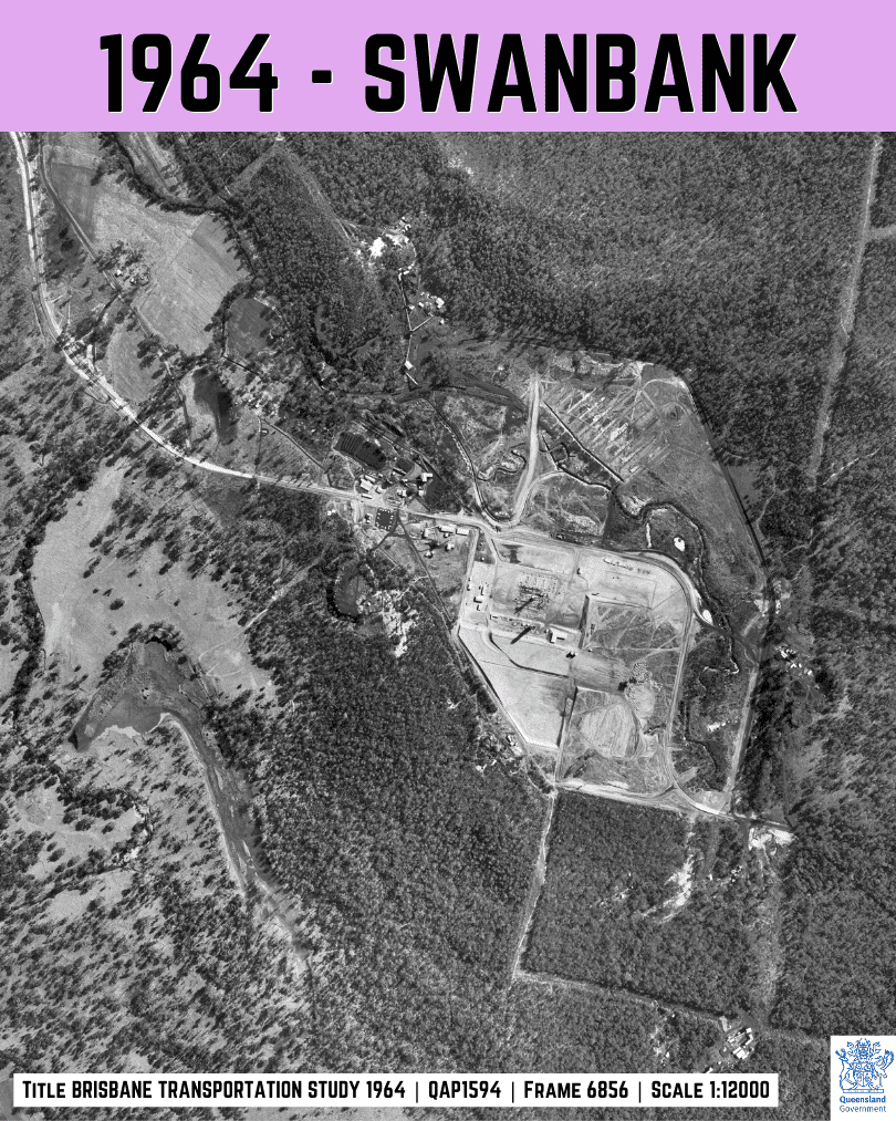
1964 – Swanbank
Between 1948 and 1964, Swanbank changes fast. Large cleared pads and new industrial buildings appear, signalling the power station build-out. The scale shift is obvious. Access roads and service corridors begin to form a dedicated precinct layout, replacing the earlier forest/bush. This is the construction era where the landscape is being re-engineered.
1971 – Swanbank
Between 1964 and 1971, the precinct looks fully established. The main plant buildings and supporting infrastructure are prominent (Swanbank Lake), and the surrounding land shows more engineered shaping to support heavy operations (power-line corridors). This is Swanbank in its coal-generation era, where everything is laid out around plant, servicing space and the management of industrial by-products.

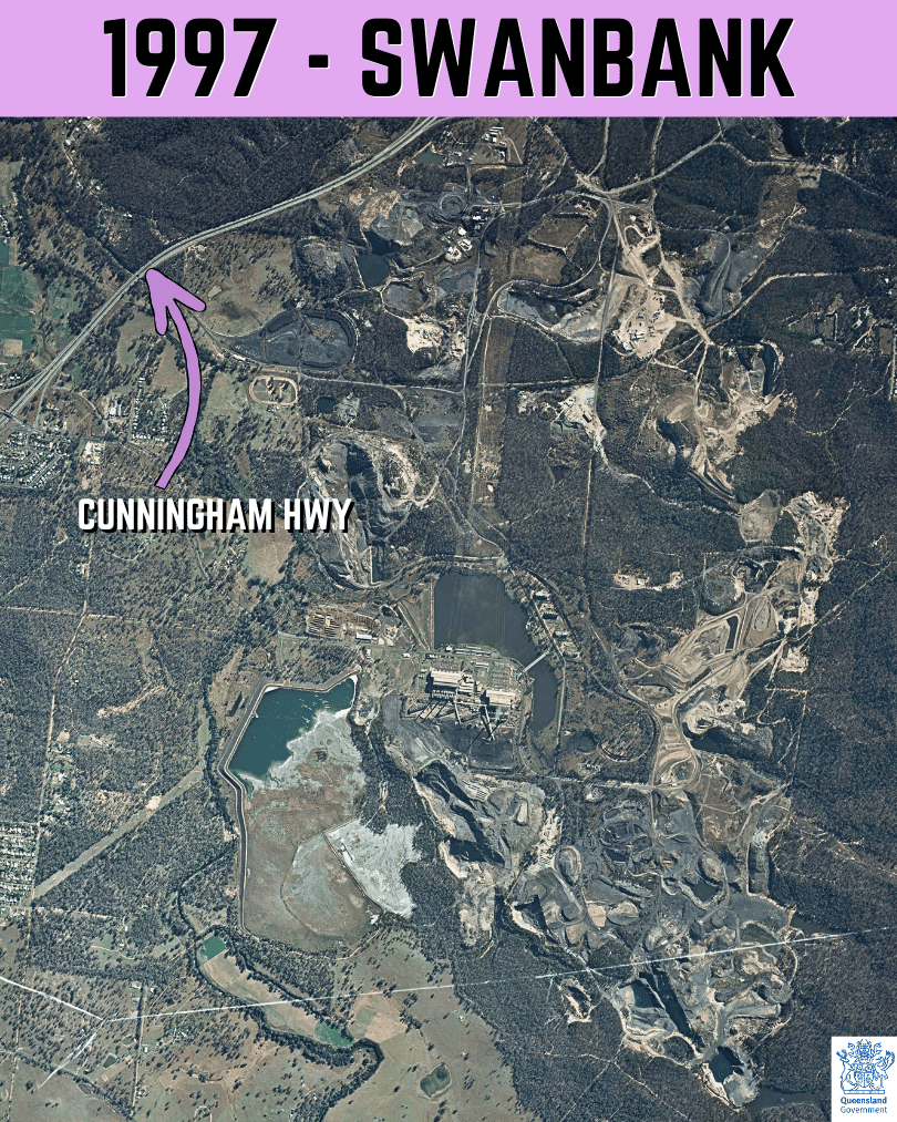
1997 – Swanbank
Between 1971 and 1997, the broader precinct becomes more complex. Additional industrial lots and supporting infrastructure appear, with more hardstand and internal roads. The surrounding transport network is also clearer, tightening links between Swanbank and the wider region. Swanbank now reads less like a single facility and more like an industrial cluster that has grown outward.
2025 – Swanbank
Between 1997 and 2025, Swanbank’s story is transition and layering. The precinct remains strongly industrial, but the mix of footprints changes as older elements shift and newer uses expand. The aerial shows a highly engineered landscape with multiple large sites in close proximity. From above, it reads as a mature energy and industry corridor rather than one single project.

RAAF Amberley

RAAF Amberley Historic Overview
- START: A long-established air base by the mid-20th century, designed around runways, dispersal areas and long-term expansion.
- WHY HERE: Large, flat inland land with room for long runways and a wide safety buffer, close to Ipswich while staying away from the coastal strip.
- FIRST PURPOSE: Airfield operations and training support, growing into a major aviation and maintenance hub over time.
- AERIAL TELLS: Runway and taxiway geometry, dispersal patterns, apron and hangar growth, housing precincts and expanding support infrastructure.
- NOW: A major Defence aviation hub with a steadily modernised airfield and extensive support footprint.
1958 – RAAF Amberley
By 1958, Amberley is already a mature air base. Multiple runways, dispersal areas and hangar zones are clearly laid out, with a much larger footprint than the surrounding farmland. The base reads as an integrated airfield and support precinct built for long-term operations. This is the “established framework” that later upgrades and new buildings slot into.

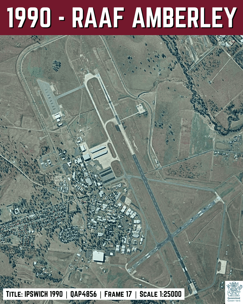
1990 – RAAF Amberley
Between 1958 and 1990, the airfield support areas consolidate. Aprons and hangar clusters look more extensive, internal roads are clearer, and the built-up precinct around the airfield has grown. The runway network remains the stable core. From above, it looks like a base that has expanded its support infrastructure around an airfield layout that was set decades earlier.
2002 – RAAF Amberley
Between 1990 and 2002, Amberley shows continued infrastructure growth. More large-roofed buildings and hardstand appear, reflecting modern aircraft support needs. The airfield geometry stays constant, while the land around it becomes more built up and better connected internally. This is a period of steady upgrade and densification rather than a complete reshape of the airfield itself.

2025 – RAAF Amberley
Between 2002 and 2025, the base looks more built out again. Larger apron areas, newer-looking hangars and expanded support zones are visible, and the surrounding region has more urban and industrial development. From the air, Amberley reads as a long-established airfield that has steadily modernised its built footprint while keeping the original runway framework as the anchor.

Willowbank Motorsport Precinct

Willowbank Motorsport Precinct Historic Overview
- START: A motorsport footprint emerges in the early 1980s, then expands steadily with more facilities and surrounding land change.
- WHY HERE: Large, flat parcels with strong highway access and enough separation from dense housing to support loud, high-speed events.
- FIRST PURPOSE: A purpose-built drag racing venue, later evolving into a broader motorsport precinct.
- AERIAL TELLS: The long drag strip alignment, growing hardstand and parking, and a steady increase in venue infrastructure over time.
- NOW: A major South East Queensland motorsport hub set within a heavily modified landscape of industry and engineered land.
1982 – Willowbank Motorsport Precinct
In 1982, the Willowbank area still reads as largely rural with the Cunningham Hwy cutting through it. Open paddocks and simple tracks dominate, and any motorsport footprint is minimal compared to later decades. This is the “before” view that makes the later venue and hardstand expansion easy to appreciate.

1985 – Willowbank Motorsport Precinct
Between 1982 and 1985, early motorsport development becomes clearer. The drag strip alignment and associated cleared areas start to stand out against the surrounding paddocks. Access and hardstand increase, and the site begins to read as a purpose-built venue rather than farmland. The change is still localised, but it sets the pattern for later precinct growth.

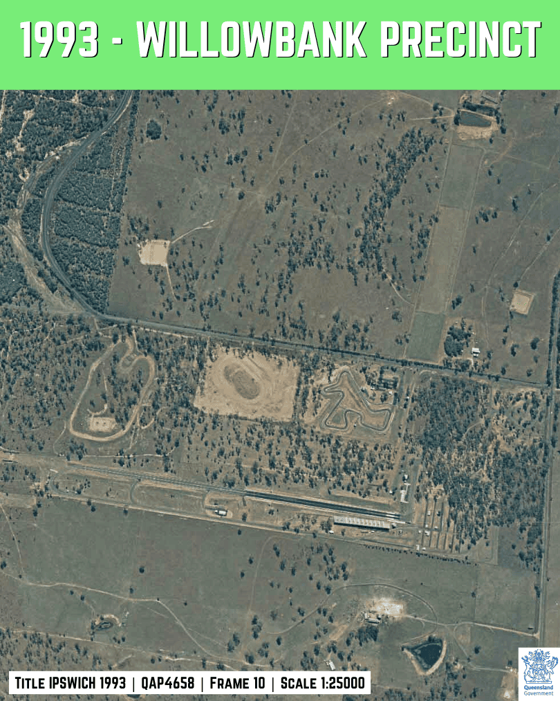
1993 – Willowbank Motorsport Precinct
Between 1985 and 1993, the precinct footprint strengthens. You can now see more than just the drag strip as the kart track and other raceways take shape. Venue infrastructure and parking areas become more obvious, and the motorsport site sits as a distinct engineered area within a still mostly rural setting. This is the “settling in” phase where the layout looks more permanent.
2000 – Willowbank Motorsport Precinct
Between 1993 and September 2000, the precinct and its surrounds change quickly. The venue looks more developed, with larger hardstand and clearer access patterns. In the wider area, disturbed land and major earthworks become more visible as the Ti Tree Bio Energy waste disposal facility takes shape to the north.

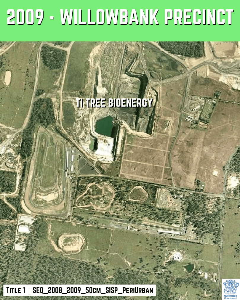
2009 – Willowbank Motorsport Precinct
Between 2000 and 2009, the precinct looks more mature and “event-ready”. More sealed surfaces, expanded parking and facility growth are easier to pick out. Surrounding land use continues to intensify, which makes the motorsport site feel less isolated than it did in earlier decades.
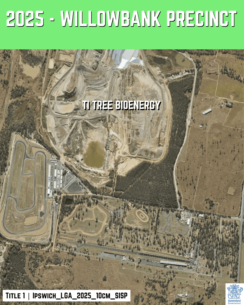
2025 – Willowbank Motorsport Precinct
Between 2009 and 2025, Willowbank reads as a fully established motorsport hub. From the air, it is now a purpose-built precinct embedded in a heavily modified corridor. The biggest change is not the strip itself, but how built up everything to the north appears from above.
Mount Marrow Quarry

Mount Marrow Quarry Historic Overview
- START: By 1971, an operating hard-rock quarry is clearly visible at Mount Marrow in this imagery series.
- WHY HERE: A high-quality rock hill close to Ipswich and South East Queensland’s construction demand, with practical haul access.
- FIRST PURPOSE: Quarrying hard rock for construction aggregates used in roads, concrete and asphalt.
- AERIAL TELLS: Benched pit faces, processing and stockpile pads, haul roads, and a steadily widening disturbed footprint.
- NOW: A significantly larger extraction footprint than the early 1970s, with the quarry benches and working areas reshaping the landscape over time.
1971 – Mount Marrow Quarry
In 1971, Mount Marrow is already operating as a hard-rock quarry. The pit area, access tracks and early stockpiles are visible, but the footprint is still relatively contained. This frame is the baseline for the long, steady expansion that follows. The quarry stands out as a sharp, engineered form inside a mostly rural landscape.

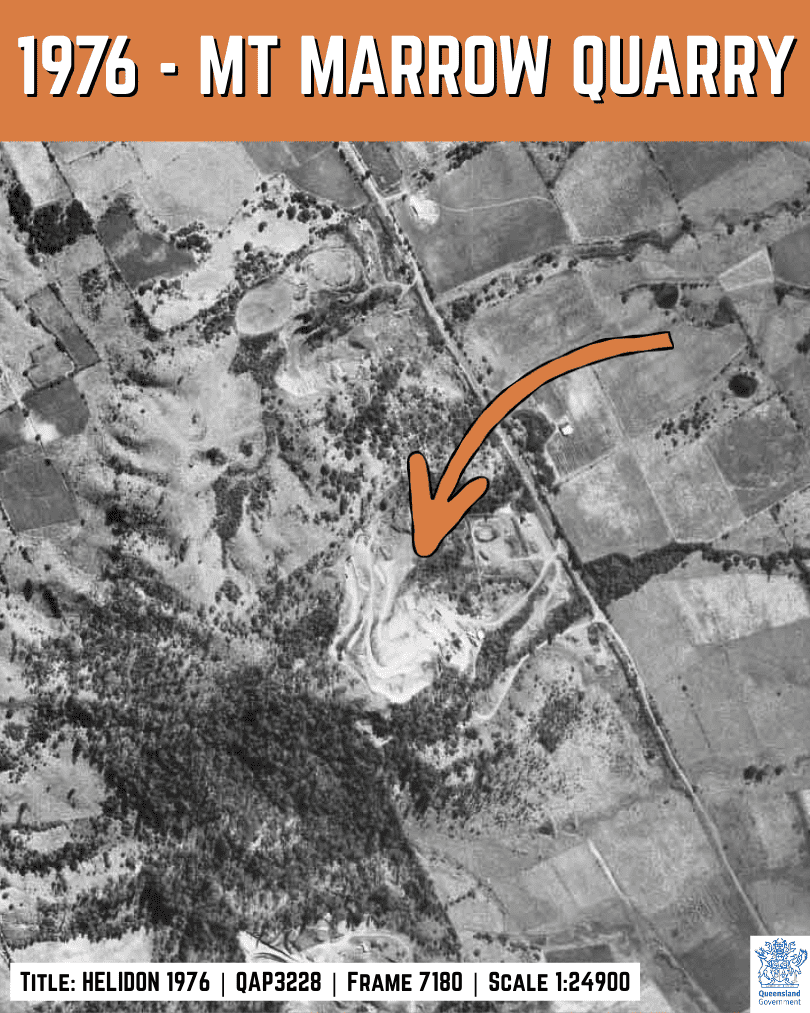
1976 – Mount Marrow Quarry
Between 1971 and 1976, the quarry expands along the rock face. The disturbed area widens, and haul routes and working pads become more defined. Growth is incremental but clear as extraction pushes deeper and the site becomes more engineered. Even at this stage, the quarry geometry is becoming a permanent feature in the local landscape.
1982 – Mount Marrow Quarry
Between 1976 and 1982, the footprint increases again. Benching and cut faces read more strongly, and the working areas around processing and stockpiling look larger. The surrounding rural land remains intact, which makes the quarry expansion easier to spot. This is the steady “more of everything” phase, rather than a single dramatic leap.

1997 – Mount Marrow Quarry
Between 1982 and 1997, Mount Marrow grows into a much larger excavation. The pit appears deeper and more complex, with wider benches and expanded working areas. Stockpile and processing layouts shift as the quarry reorganises for higher throughput.

2009 – Mount Marrow Quarry
Between 1997 and 2009, the quarry becomes an even more dominant landform.
Here is how it appears from Thagoona Haigslea Rd exactly 1 km across open paddock.

Mt Marrow Quarry was featured in our recent GuessWhere #039 game.
The disturbed footprint spreads, benches multiply, and the internal road network looks more substantial. Stockpile areas expand and shift, showing active extraction and processing. This is the period where the scale is unmistakable, even in a quick glance, because the quarry geometry fills more of the frame.

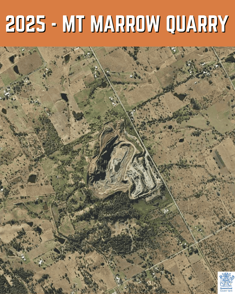
2025 – Mount Marrow Quarry
Between 2009 and 2025, Mount Marrow’s long-term expansion is obvious. The pit and benches extend further, and operational areas look more established and consolidated. Even without one single “before and after” moment, the cumulative effect across decades is a landscape progressively reshaped by extraction. This final frame shows how permanent the footprint has become.
Sources
- Queensland Globe. QldGlobe.information.qld.gov.au.
- QImagery. QImagery. information.qld.gov.au.
- City of Ipswich. Wikipedia.org.
- Mt Marrow Blue Metal Quarries. MtMarrow.com.
- Swanbank Power Station. Wikipedia.org.
- Establishment of RAAF Base Amberley. Airforce.gov.au.
- Building a Motorsport Precinct: Willowbank Raceway. TheRaceTorque.com.
- Redbank. PictureIpswich.com.au.