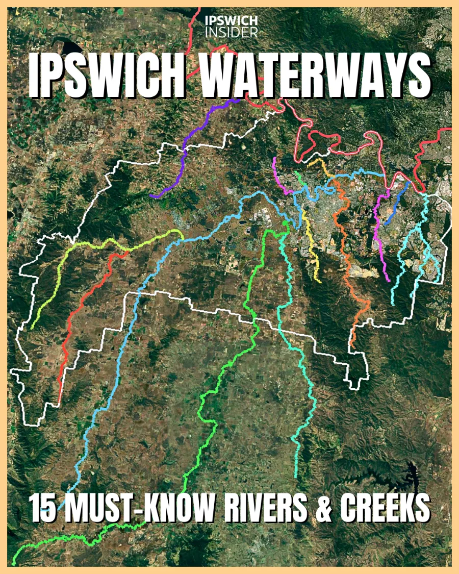
Ipswich Waterways at a Glance
- Field guide: The 15 most important waterways that drain our rain, grow food, and shape life across the Ipswich floodplain.
- Rivers & creeks: The Bremer is the trunk river through Ipswich, fed by the big 7 (+feeders)—Warrill (+Purga), Bundamba, Deebing, Western (+Franklin Vale), Sandy (Tivoli), Ironpot and Mihi—with Brisbane River feeder creeks (Woogaroo, Opossum, Mountain, Goodna, Six Mile) doing vital daily work too.
- 15 infographics: Each river and creek gets a custom graphic with its map, physical characteristics and more. Check them out below.
🔢 By The Numbers
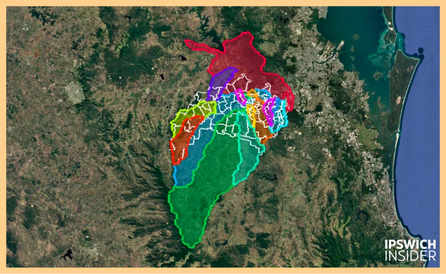
Ipswich waterway drainage basins overtop Ipswich’s border (white outline)
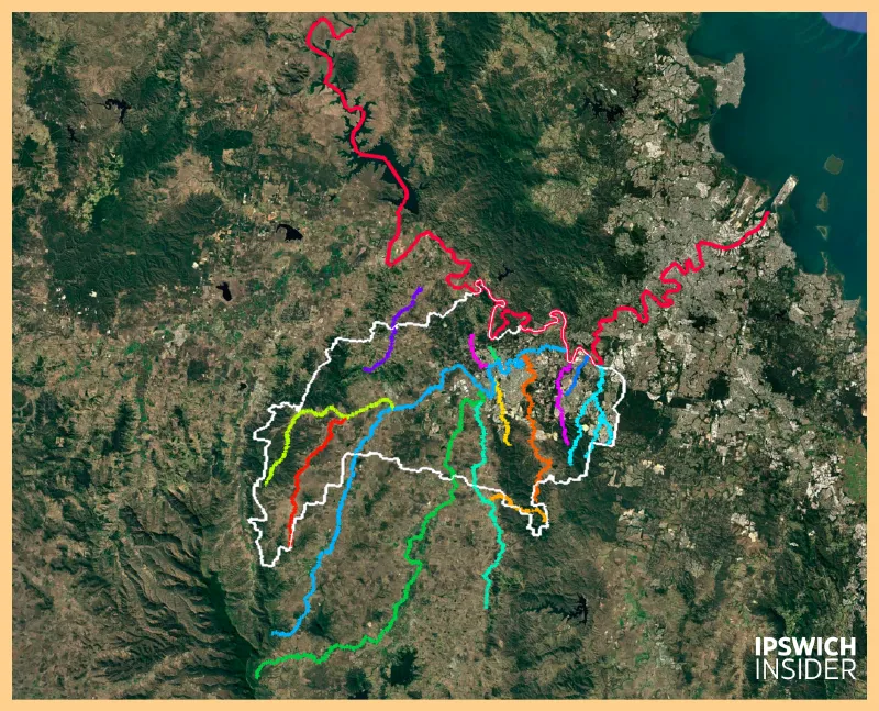
Coloured lines are Ipswich waterways (Long red one is Brisbane River)
- 2 — trunk rivers: Brisbane and Bremer shape everything
- 344 km — Brisbane River (Ipswich reach profiled)
- 13,570 km² — Total Brisbane river catchment
- 100 km — Bremer length
- 2,028 km² — Bremer catchment draining rural and urban Ipswich
- 19 km — Bremer is tidal to Woodend
- 5.9 km² — Mihi Creek has the smallest catchment on our list of 15
- 150,000+ — plants in Small Creek (Bundamba feeder) naturalisation
- 2011 & 2022 — modern flood years shaping memory
- 3 — main river access nodes: Goodna, Joseph Brady Park, Colleges Crossing
Is Warrill Creek bigger than Bundamba Creek?
Is Woogaroo Creek bigger than Goodna Creek?
Which creek drains the new runoff from Providence, South Ripley and White Rock Estate?
Which creek has the highest starting point?
Which creek has the steepest runoff?
If you have asked questions like these you’re in the right place.
Today, we’re looking at Ipswich waterways. The biggest, longest and most important to our everyday life.
Ready to jump in?
Jump To:
Brisbane River • Bremer River • Warrill Creek • Bundamba Creek • Deebing Creek • Purga Creek • Black Snake Creek • Western Creek • Franklin Vale Creek • Woogaroo Creek (incl. Opossum & Mountain) • Goodna Creek • Six Mile Creek • Mihi Creek • Ironpot Creek • Sandy Creek (Tivoli)
Read this right: “Health snapshot” is ecological condition (clarity, nutrients, oxygen, habitat, fish and invertebrates), not drinking safety. Tap water is treated. Nicknames are editorial shorthand for what each waterway is best known for.
Help us improve: We do our best to be accurate, but we’re a lean local operation — if you spot an error or have better local knowledge, please let us know via our contact info and we’ll fix it fast.
More Ipswich Gold:
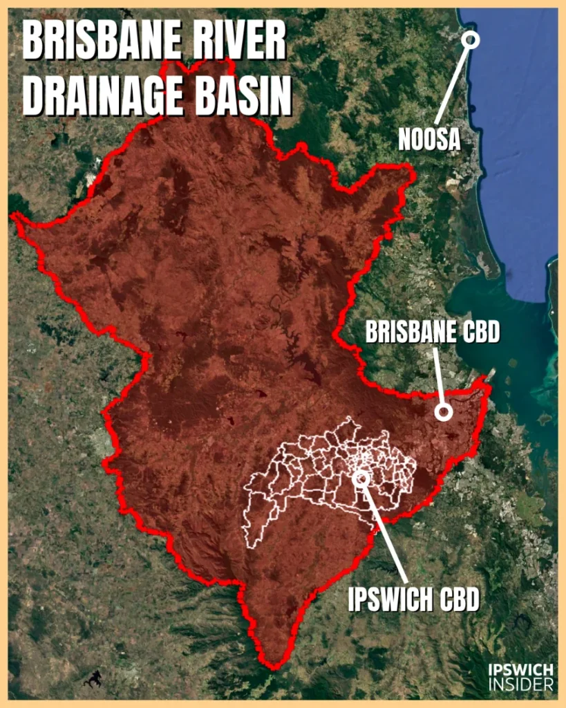
Brisbane River
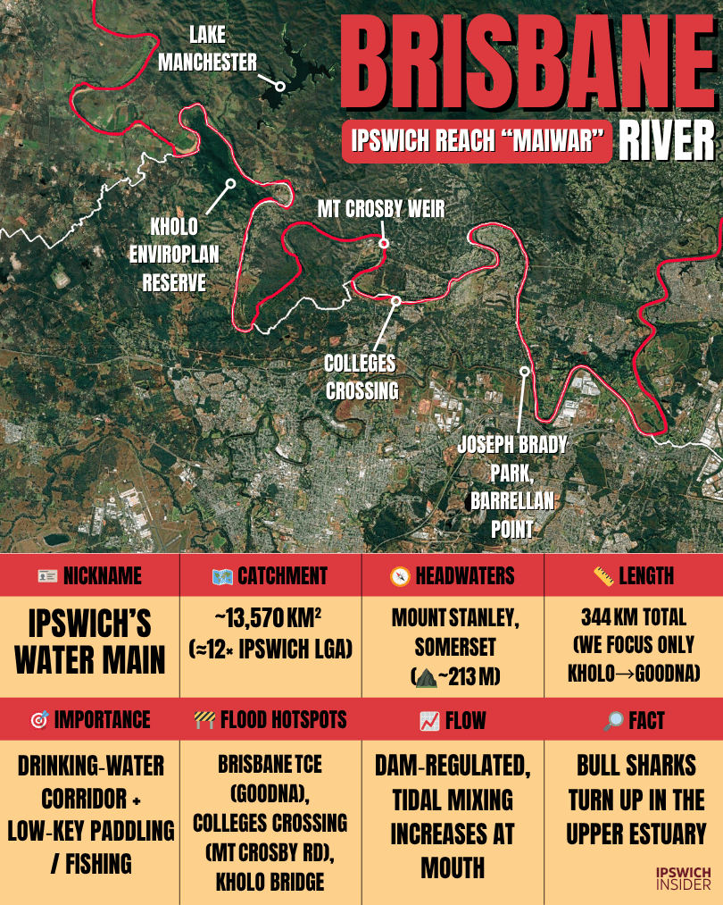
See Brisbane River’s drainage basin:
It includes the areas of all it’s tributaries (including the big 3: Lockyer Creek 3,032 km2, Bremer 2,032km2, and Stanley River 1,532 km2).
🎯 Role and identity
Main use or benefit
- Water supply & recreation: On the Ipswich reach, raw water passes Kholo toward Mt Crosby treatment and locals boat, paddle and fish from Goodna and Barellan Point.
Nickname
- Moniker: Ipswich Water Main — the city’s quiet lifeline for drinking water and weekends. Not the CBD fireworks reach.
Scope note
- Which part: Kholo/Chuwar past Karalee/Barellan Point to Goodna/Riverview. We acknowledge “Maiwar”. We use “Brisbane River” for everyday language.
🧭 Physical setting
Where it starts
- Headwaters & LGA: Mount Stanley, Somerset Region, far upstream of Ipswich.
- Elevation at rise: ~213 m.
Length
- Main stem: ~344 km total. This profiles the Ipswich reach.
Catchment
- Area & setting: ~13,570 km² to the Port Office gauge. Ipswich intersects the Mid and Lower Brisbane sub‑catchments forming the city’s northern edge.
Flow and volume
- Regime: Wivenhoe releases steady the mid‑reaches and tides influence the lower river. Long wet spells still lift levels fast.
🌊 Water and wildlife
Health snapshot
- Condition: Generally sound through Mid‑Brisbane, muddier after big rain. Clarity rebounds with dry weeks and shaded banks.
Animals & protected areas
- Wildlife: Lungfish habitat persists upstream. Kholo Reserve and Colleges Crossing are nature‑recreation nodes on this stretch.
Flooding
- Hotspots: Goodna, Karalee and Barellan Point remember 2011 and 2022. Backwater from major events can push into local creeks.
🏘️ People and places
Suburbs drained
- Start to finish: Kholo/Chuwar → Karalee/Barellan Point → Muirlea/North Tivoli → Riverview/Goodna.
People & housing
- Settlement: Acreage riverfronts at Karalee/Barellan Point. Denser Goodna/Riverview. Paddock edges near Muirlea.
Major crossings & infrastructure
- Bridges & works: Kholo Bridge and Mt Crosby Weir bracket the reach. Colleges Crossing is the community hub.
Access & boat ramps
- Launch: Goodna Boat Ramp at Richardson Park, Joseph Brady Park at the Bremer mouth, and facilities at Colleges Crossing.
Swimming & fishing
- Popular: Bank fishing and kayaking at Joseph Brady Park and Kholo Reserve. Check current warnings and flows.
🕰️ Stories and history
Settlement & industry history
- River trade & works: From colonial supply runs to modern recreation. Training walls near the Bremer mouth shaped navigation and banks.
🔎 Brisbane River cool facts box
- 1️⃣ Cool: Bull sharks turn up surprisingly far upstream, near the Ipswich boundary.
- 2️⃣ History: Ruins of an 1890s pumping station hide upriver in the Kholo scrub.
- 3️⃣ Infrastructure: On this reach, Kholo Bridge and Mt Crosby Weir are the signature structures.
Bremer River

See Bremer River’s catchment — 2,032 km2
Everything inside the orange drains to the Bremer River – including: Warrill Creek, Bundamba Creek, Deebing Creek, Western Creek (and others). Areas of Ipswich not under orange drain to the Brisbane River.
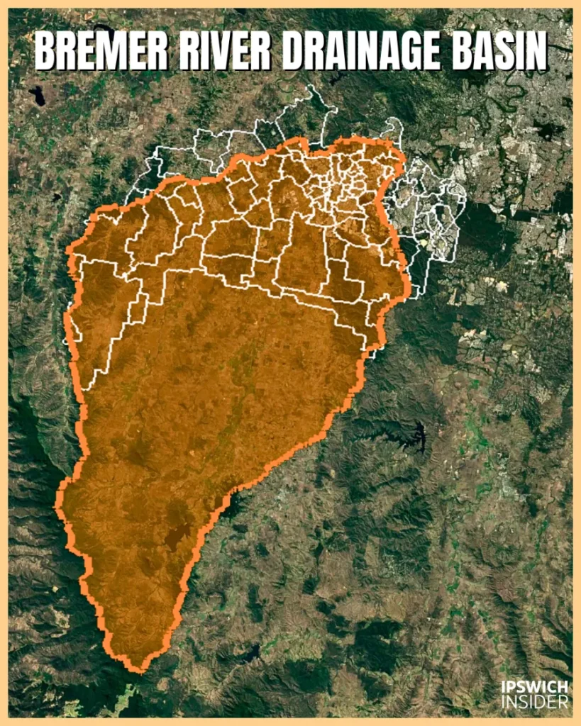
See Bremer’s mainstem sub-catchment:
The blue shows the Bremer River mainstem catchment — land that runs direct to the Bremer, excluding the tributary sub-catchments.

🎯 Role and identity
Main use or benefit
- Catchment trunk: The city’s drainage backbone, moving water, sediment and woody debris from Warrill, Purga, Bundamba, Deebing, Western, Franklin Vale and smaller creeks to the Brisbane River.
Nickname
- Moniker: Mud Monster — high sediment loads that colour the Brisbane after big rain.
🧭 Physical setting
Where it starts
- Headwaters & LGA: Western slopes of the Main Range (Scenic Rim), then through rural and urban Ipswich.
- Elevation at rise: ~394 m.
Length
- Main stem: ~100 km. Tidal estuary on the lower 19 km.
Catchment
- Area & setting: 2,028 km² draining Rosewood, Walloon, Thagoona, Karrabin, Ipswich CBD, Basin Pocket, North Booval, Moores Pocket, Tivoli and Chuwar.
Flow and volume
- Regime: Flashy after storms. Permanent pools in dry spells. Strong tidal push on lower bends exposing wide mudbanks. The estuary extends to Lynch’s Crossing upstream of Hancock Bridge.
🌊 Water and wildlife
Health snapshot
- Condition: Generally poor at whole‑catchment scale in wet years. Bank stabilisation, riparian cover and rural hotspot works are key levers.
Animals & protected areas
- Wildlife: Estuarine fish use the lower river. Woodland corridors in upper and middle reaches still carry koalas and a healthy bird mix.
Flooding
- Hotspots: Basin Pocket, North Booval and Moores Pocket flood repeatedly. Brisbane River backwater can raise levels quickly near the mouth.
🏘️ People and places
Suburbs drained
- Start to finish: Rosewood/Walloon → Ipswich CBD/Tivoli → Moores Pocket/Barellan Point to the Brisbane River.
People & housing
- Settlement: Historic neighbourhoods on inner bends. Industry on flats near North Booval and Tivoli.
Major crossings & infrastructure
- Bridges & nodes: The David Trumpy Bridge anchors the CBD reach. Training walls and bank works shape the lower estuary bends.
Access & boat ramps
- Launch: Cribb Park and River Heart give easy access. Many anglers favour Joseph Brady Park at the Brisbane confluence.
Swimming & fishing
- Advisories: Follow current fish‑consumption notices. Catch‑and‑release is the safe default where advisories apply.
🕰️ Stories and history
Settlement & industry history
- Port to power: From wool barges and wharves to coal, coke and rail — the Bremer is Ipswich’s working‑river story.
🔎 Bremer River cool facts box
- 1️⃣ Cool: An elephant helped refloat the steamer Bremer in 1941.
- 2️⃣ History: Queensland’s first railway launched from North Ipswich in 1865 and stone abutments still stand.
- 3️⃣ Infrastructure: A 1970s Yamanto flood‑bypass canal never left paper.
Warrill Creek
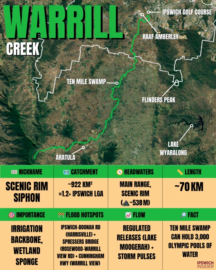
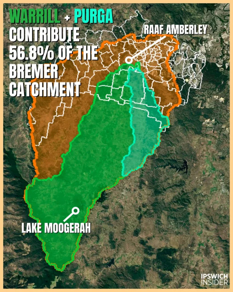
Check out Warrill’s catchment:
In the image below Warrill Creek catchment is green and Purga Creek is turquoise — they overlay the orange, which is the Bremer catchment. Purga feeds into Warrill and Warrill feeds into Bremer. Bremer then feeds into Brisbane River at Joseph Brady Park. Warrill Creeks basin is 45.5% of the Bremer basin and if you include Purga — Warrill Creek contributes 56.8% of the entire Bremer River drainage basin. Warrill is massive!
🎯 Role and identity
Main use or benefit
- Agriculture & wetlands: Lake Moogerah releases support Fassifern irrigation and Ten‑Mile Swamp acts as the catchment’s sponge.
Nickname
- Moniker: Scenic Rim Siphon — mountain water to farms then across Ipswich’s lower plains.
🧭 Physical setting
Where it starts
- Headwaters & LGA: Main Range National Park near Tarome and Aratula then into Ipswich near Willowbank and Amberley.
- Elevation at rise: ~538 m.
Length
- Main stem: ~70 km from Moogerah via Kalbar and Harrisville to RAAF Amberley and the Bremer.
Catchment
- Area & setting: Large rural basin including regulated Reynolds Creek. Lake Moogerah’s ~200 km² feeder is more than 20% of Warrill’s total.
Flow and volume
- Regime: Mix of regulated releases and storm pulses. Lower farms respond quickly to summer downpours.
🌊 Water and wildlife
Health snapshot
- Condition: Working river with gains where banks are fenced and replanted. Wet years reshape bars and backwaters.
Animals & protected areas
- Wildlife: Waterbirds crowd Ten‑Mile Swamp after rain. Native fish work the long pools and runs.
Flooding
- Hotspots: Harrisville and the Amberley plains go broad and shallow in long rain. Bremer backwater can compound lower‑reach flooding.
🏘️ People and places
Suburbs drained
- Start to finish: Aratula/Moogerah → Kalbar/Harrisville → Peak Crossing, Willowbank, Amberley, Yamanto → the Bremer.
People & housing
- Settlement: Farming towns and acreage with a defence‑industry fringe at Amberley.
Major crossings & infrastructure
- Crossings & works: Cunningham Hwy and Ipswich–Boonah Road span the floodplain. Old weirs like Churchbank sit buried in silt.
Access & boat ramps
- Launch: Public boating at Lake Moogerah. The creek is mostly private frontage.
Swimming & fishing
- Spots: Lake Moogerah under SIPS is popular for bass and goldens.
🕰️ Stories and history
Settlement & industry history
- Farming belt: Dairying, orchards and irrigation shaped channels and wetlands and still define local life.
🔎 Warrill Creek cool facts box
- 1️⃣ Cool: Locals call the vast wetland from Warrill View to Harrisville east of the Cunningham Hwy and West of Warrill Creek “Ten‑Mile Swamp”.
- 2️⃣ History: Wartime stories tell of vehicles dumped in the lower swamps as camouflage and scrap.
- 3️⃣ Infrastructure: A modern flood‑control dam near Willowbank was explored then shelved.
Bundamba Creek

See Bundamba Creek’s catchment:
Bundamba Creek Catchment (≈114 km²). Drains Ripley Valley and the Swanbank–Blackstone corridor before meeting the Bremer at Bundamba. A naturally flashy system, with new estates (Providence, Ecco Ripley, Whiterock) adding detention/bioretention to slow peaks and improve quality.

🎯 Role and identity
Main use or benefit
- Growth spine: Stormwater backbone for the Ripley corridor and a green link through Raceview, Bundamba and Booval. Small Creek naturalisation is the flagship “drain-to-stream” project.
Nickname
- Moniker: Reborn Drain — the concrete-to-creek transformation underway.
🧭 Physical setting
Where it starts
- Headwaters & LGA: East of Flinders Peak then north through the Ripley Valley across Ipswich to the Bremer near North Booval.
- Elevation at rise: ~212 m.
Length
- Main stem: ~30 km through Ipswich to the Bremer.
Catchment
- Area & setting: ~114 km² across Swanbank and White Rock through Ripley, Raceview, Bundamba and Booval. Upper reaches retain bush; mid-reaches narrow then open onto broader floodplains. Lower reaches are tightly urban.
Flow and volume
- Regime: A naturally very flashy creek with very quick storm peaks and short recessions; lower reaches can see rapid backflow/inundation during events. Springs and urban baseflow hold pools in dry spells.
🌊 Water and wildlife
Health snapshot
- Condition: Urbanisation and legacy mining drive erosion and sediment loads; recovery focuses on revegetating banks, naturalising channels, re-engaging floodplains, and adding wetlands/bioretention to improve water quality.
Animals & protected areas
- Wildlife: Platypus recorded around Daly’s Lagoon. The corridor links White Rock to the Flinders–Karawatha conservation arc.
Flooding
- Hotspots: Swanbank Rd (Colin Keidge Bridge) can choke with debris and close in major events; Cunningham Hwy near the Swanbank exit experiences ponding/over-road flow in big storms. Blackstone, Bundamba and Booval lowlands see rapid, short-lived flash flooding. Floodways through parks and streets move water off flats.
🏘️ People and places
Suburbs drained
- Start to finish: South Ripley/Deebing Heights → Ripley → Raceview/Flinders View → Bundamba/Booval/East Ipswich/North Booval.
People & housing
- Settlement: New estates meet long-settled suburbs. Density steps up toward the rail line and Brisbane Road.
Major crossings & infrastructure
- Crossings & projects: Creek Street and Brisbane Road bridges span the lower corridor; Swanbank Rd (Colin Keidge Bridge) is a known closure point in major events. Small Creek added off-line wetlands and hundreds of thousands of native plants.
Access & boat ramps
- Launch: No ramps on the creek. Use Bremer and Brisbane River parks.
Swimming & fishing
- Advisories: Follow PFAS and water-quality signage. Fish Joseph Brady Park or Kholo on the rivers.
🕰️ Stories and history
Settlement & industry history
- Coal & power: Swanbank stations, ash dams and rail spurs shaped the corridor and still influence drainage.
🔎 Bundamba Creek cool facts box
- 1️⃣ Cool: Small Creek shows the template—meanders, riffles, shade and pools replacing concrete.
- 2️⃣ History: In the 1918 drought a “Bundamba Dam” site was scouted but never built.
- 3️⃣ Infrastructure: Off-line wetlands and bioretention slow flows, trap sediment and create fish refuge as part of coordinated catchment restoration.
Deebing Creek
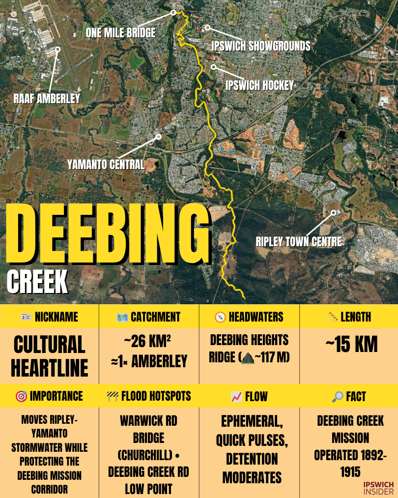
See Deebing Creek’s catchment (≈26 km²):
Drains Deebing Heights–Ripley–Yamanto before joining the Bremer underneath One Mile Bridge. It’s a short headwater creek that is one of Ipswich’s fastest responding creeks after heavy rains.

🎯 Role and identity
Main use or benefit
- Cultural & ecological corridor: Threads the Deebing Creek Mission precinct and carries bushland values through Ripley and Yamanto into the Bremer network.
Nickname
- Moniker: Cultural Heartline — heritage, landscape and neighbourhood growth meet along this ribbon of water.
🧭 Physical setting
Where it starts
- Headwaters: Grampian Hills at the south end of Deebing Heights.
- Elevation at rise: ~117 m.
Length
- Main stem: Short, steep run from ridges to Bundamba Creek and the Bremer near One Mile Bridge.
Catchment
- Area & setting: ~26 km² across Deebing Heights, Ripley and Yamanto then out through Churchill and One Mile.
Flow and volume
- Regime: Ephemeral with quick pulses. Detention basins and water‑sensitive design slow and clean flows.
🌊 Water and wildlife
Health snapshot
- Condition: Sensitive to construction runoff but improving with buffers and detention.
Animals & protected areas
- Wildlife: Koalas and wallabies move through intact patches. Platypus traces have been reported.
Flooding
- Hotspots: Yamanto and Flinders View crossings can overtop fast under summer cells.
🏘️ People and places
Suburbs drained
- Start to finish: Deebing Heights/South Ripley → Ripley → Yamanto → One Mile/Churchill.
People & housing
- Settlement: New estates blend into long‑standing suburbs. The corridor doubles as a greenway.
Major crossings & infrastructure
- Crossings & projects: New arterials and culverts in the Ripley PDA. Mission and cemetery precincts are heritage‑listed.
Access & boat ramps
- Launch: No creek ramps. Use river nodes at Kholo, Goodna and Barellan Point.
Swimming & fishing
- Advice: Best for walking and wildlife. Do your fishing on the big rivers.
🕰️ Stories and history
Settlement & industry history
- Mission era: Deebing Creek Mission (1892–1915) preceded the Purga Mission. Heritage campaigns continue as the valley urbanises.
🔎 Deebing Creek cool facts box
- 1️⃣ Cool: Headwaters sit below the dramatic White Rock outcrops — a city‑favourite lookout.
- 2️⃣ History: A 1970s reservoir concept that would have inundated the mission was never funded.
- 3️⃣ Infrastructure: The 2019 clay‑slurry spill caused a major fish kill and tougher site practices.
Purga Creek
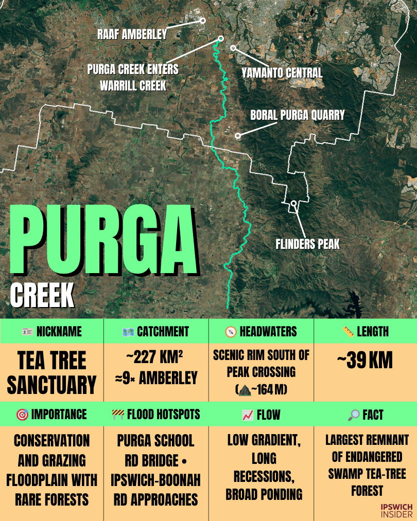
See Purga Creek’s catchment (≈229 km²):
Big paddock basin through Purga–Peak Crossing feeding Warrill Creek just upstream of the Warrill–Bremer hook-up. Think of it as Warrill’s easygoing sidekick—wide floodplains, long travel times, and peaks that roll in rather than spike.

🎯 Role and identity
Main use or benefit
- Conservation & grazing: A working floodplain creek with nationally significant Swamp Tea‑tree forest at Purga Nature Reserve.
Nickname
- Moniker: Tea‑tree Sanctuary — the largest protected stand of this endangered forest type in SEQ.
🧭 Physical setting
Where it starts
- Headwaters & LGA: Scenic Rim south of Peak Crossing.
- Elevation at rise: ~164 m.
Length
- Main stem: Behaves like a broad wetland system rather than one simple thread.
Catchment
- Area & setting: ~227 km² through Peak Crossing and Purga into Warrill. Low gradients create wide ponding after rain.
Flow and volume
- Regime: Long recessions on a low‑slope floodplain. Pools and wetlands persist in drought.
🌊 Water and wildlife
Health snapshot
- Condition: Turbid and nutrient‑rich in grazed sections. Fencing stock out and re‑planting banks bring quick wins.
Animals & protected areas
- Wildlife: Koalas and glossy black‑cockatoos use woodland edges. The Purga boardwalk showcases the rare tea‑tree forest.
Flooding
- Hotspots: Low approaches like Purga School Road go under in long rain and turn flats into a shallow lake.
🏘️ People and places
Suburbs drained
- Start to finish: Peak Crossing/Goolman foothills → Purga → toward Yamanto then into Warrill and the Bremer.
People & housing
- Settlement: Small townships, acreage and grazing paddocks with rural lifestyle pockets on higher margins.
Major crossings & infrastructure
- Crossings & heritage: Ipswich–Boonah Road and the Cunningham Hwy step over Purga and Little Purga arms. The reserve boardwalk is the showcase asset.
Access & boat ramps
- Launch: Walking and birding creek. Boating is for the big rivers nearby.
Swimming & fishing
- Spots: Not a swimming creek. Think birds, shade and quiet paths.
🕰️ Stories and history
Settlement & industry history
- Missions & farms: The Purga Mission followed Deebing. Farming on these flats dates to the 1850s.
🔎 Purga Creek cool facts box
- 1️⃣ Cool: In 1977 a long swamp reach subsided about a metre overnight and left a new lagoon.
- 2️⃣ History: Miners diverted parts of the creek in the 1880s to keep tunnels dry.
- 3️⃣ Infrastructure: A 1950s dam idea was dropped after surveys found the catchment too small.
Black Snake Creek

See Black Snake Creek’s catchment:
≈96 km² drains to the Brisbane River. For Marburg, Black Snake is the town’s stormwater spine: it gathers runoff off surrounding ridges, routes it through/around the township, and—together with floodplain storage and small local works—helps take the punch out of summer downpours. The low corridor doubles as a green buffer and wildlife line, but also sets flood-aware planning for roads, ovals and rural blocks.

🎯 Role and identity
Main use or benefit
- Town resilience: The detention basin above Marburg and creek works slow and spread peaks to protect the village.
Nickname
- Moniker: Marburg Flood Buffer — small creek doing a big job for one township.
🧭 Physical setting
Where it starts
- Headwaters & LGA: Little Liverpool Range.
- Elevation at rise: ~209 m.
Length
- Main stem: Village‑scale and short with a fast response to rain.
Catchment
- Area & setting: ~35 km² around Marburg, mostly grazing with rural residential pockets.
Flow and volume
- Regime: Flashy uplands moderated by the detention basin. Summer cells can still lift levels quickly in town.
🌊 Water and wildlife
Health snapshot
- Condition: Targeted projects have stabilised key banks and reduced sediment pulses into the Brisbane system.
Animals & protected areas
- Wildlife: Rural riparian strips support waterbirds and small fish. Every metre of fenced bank helps.
Flooding
- Hotspots: Town centre and low crossings. The basin takes the edge off the worst spikes.
🏘️ People and places
Suburbs drained
- Start to finish: Little Liverpool uplands → Marburg → farms toward the Brisbane River.
People & housing
- Settlement: Compact village with acreage surrounds and a wide creek flat beside the main street.
Major crossings & infrastructure
- Crossings & works: Warrego Hwy culverts and local bridges. The 2002 detention basin is the key flood asset.
Access & boat ramps
- Launch: No ramps here. Use Brisbane River ramps nearby.
Swimming & fishing
- Spots: Not a swimming creek. Locals use parks and the river nodes.
🕰️ Stories and history
Settlement & industry history
- Village creek: The channel helped define historic Marburg’s street layout.
🔎 Black Snake Creek cool facts box
- 1️⃣ Cool: This little creek still influences water quality upstream of the Mt Crosby intake corridor.
- 2️⃣ History: Community‑led restoration projects here stretch back more than a decade.
- 3️⃣ Infrastructure: The detention basin dramatically altered local flood behaviour and stands as a quiet success.
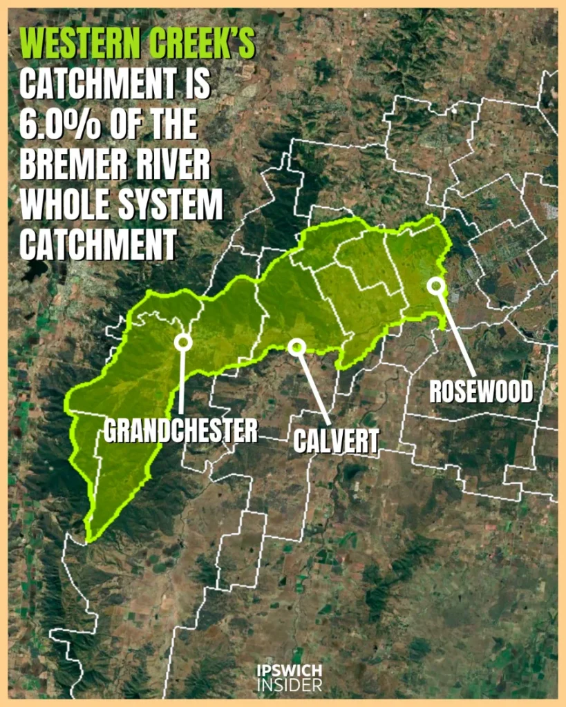
Western Creek

See Western Creek’s catchment:
≈122 km² (~6% of Bremer). A rural sub-catchment on the western flank of the Bremer system that takes Franklin Vale Creek and drains broad grazing country before joining the Bremer River. Travel times are longer and floodplain storage is larger than the urban creeks, so peaks tend to be slower and wider rather than sharp spikes.
🎯 Role and identity
Main use or benefit
- Rural production & recreation: Drains grazing and cropping country, feeds wildlife corridors toward the Bremer and frames the Hidden Vale landscape.
Nickname
- Moniker: Railway Country Creek — Rosewood to Grandchester is the cradle of Queensland rail.
🧭 Physical setting
Where it starts
- Headwaters & LGA: Little Liverpool Range.
- Elevation at rise: ~336 m.
Length
- Main stem: Not formally published. One of the larger Bremer sub‑catchments by stream miles.
Catchment
- Area & setting: ~120 km² from steep gullies to Bremer plains around Rosewood and Lower Mount Walker.
Flow and volume
- Regime: Flash floods after summer storms with long dry‑season pools. Stock‑exclusion and off‑stream watering improve clarity and banks.
🌊 Water and wildlife
Health snapshot
- Condition: Rural reaches respond to basics like fencing, revegetation and grade control on eroding bends.
Animals & protected areas
- Wildlife: Platypus eDNA detections and repeated frog and koala records in blue‑gum flats near treated sites.
Flooding
- Hotspots: Rosewood lowlands and the northern arms that rise fast under summer cells.
🏘️ People and places
Suburbs drained
- Start to finish: Grandchester → Calvert/Lanefield → Rosewood → Lower Mount Walker → the Bremer.
People & housing
- Settlement: Country towns and farm blocks with scattered rural residential on higher ground.
Major crossings & infrastructure
- Crossings & works: Historic rail culverts and bridges in paddocks. Rosewood WWTP discharges via lagoons and wetlands into Western Creek just before the confluence.
Access & boat ramps
- Launch: No public ramps on the creek. Use Bremer and Brisbane nodes.
Swimming & fishing
- Spots: Mostly private frontage. Public fishing is better on the main rivers.
🕰️ Stories and history
Settlement & industry history
- Rail pioneer: The Ipswich–Grandchester line opened in 1865 and the creek valley carried early timber and farm output.
🔎 Western Creek cool facts box
- 1️⃣ Cool: Hidden Vale’s 110 km MTB network sits on ground draining to Western Creek so you ride the divide before seeing the water.
- 2️⃣ History: A 2011 flash flood exposed Ice‑Age bones in silt banks near Grandchester.
- 3️⃣ Infrastructure: Western meets Franklin Vale at Calvert which is now a flagship repair zone.
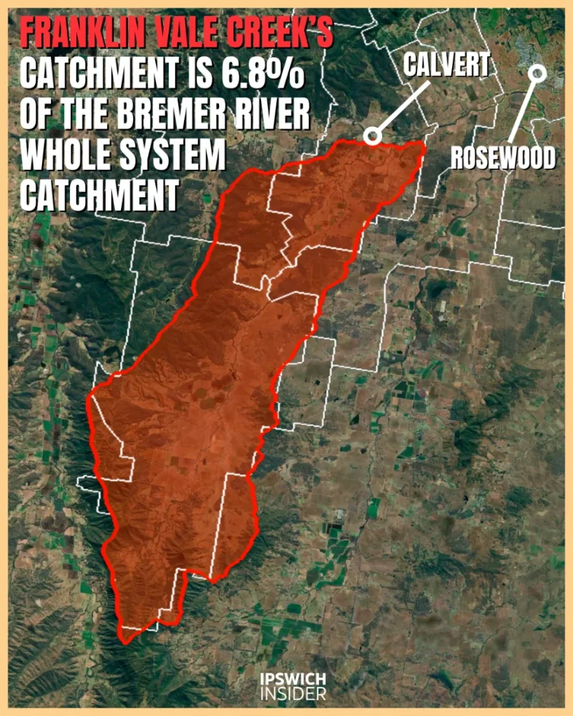
Franklin Vale Creek
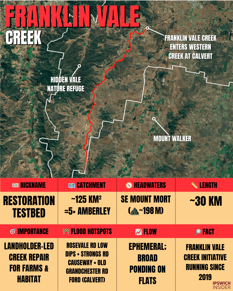
See Franklin Vale Creek’s catchment:
≈138 km² (~6.8% of Bremer). A rural headwater basin from the foothills all around Franklin Vale/Grandchester, flowing via Western Creek → Bremer River. Broad grazing flats and long travel paths give it a slower, rolling response compared with the urban creeks.
🎯 Role and identity
Main use or benefit
- Pasture & biodiversity: Council–landholder testbed for creek repair. Fencing, off‑stream watering and revegetation stabilise banks and boost habitat.
Nickname
- Moniker: Restoration Testbed — practical works here scale across the valley.
🧭 Physical setting
Where it starts
- Headwaters & LGA: SE Mount Mort.
- Elevation at rise: ~198 m across several small arms.
Length
- Main stem: Not formally published and a substantial arm of Western Creek.
Catchment
- Area & setting: ~125 km², ~91% within Ipswich. Mostly pasture with woodland patches.
Flow and volume
- Regime: Ephemeral with lingering pools in the dry. Channels connect under sustained rain.
🌊 Water and wildlife
Health snapshot
- Condition: Improving at treated sites. Untreated gullies still shed sediment in big storms.
Animals & protected areas
- Wildlife: Critically endangered Box‑Gum Grassy Woodland and Swamp Tea‑tree remnants survive along the creek line.
Flooding
- Ponding: Low country stores flows. “Slow, spread, soak” works recharge soils and reduce scouring.
🏘️ People and places
Suburbs drained
- Start to finish: Franklin Vale/Rosevale → Lanefield/Calvert where it meets Western Creek.
People & housing
- Settlement: Farms and acreage dominate with scattered localities and long lanes.
Major crossings & infrastructure
- Crossings & works: Local fords and bridges plus many small off‑line stock watering points that keep cattle off banks.
Access & boat ramps
- Launch: Private frontages mean no public ramps. Use main rivers for boating.
Swimming & fishing
- Spots: Not a swimming creek. Public fishing is better on the Bremer and Brisbane.
🕰️ Stories and history
Settlement & industry history
- Grazing belt: Generations of farm use shaped gullies and flats. Today’s program heals yesterday’s cuts while keeping properties productive.
🔎 Franklin Vale Creek cool facts box
- 1️⃣ Cool: Before‑and‑after drone footage shows banks knitting back once stock are excluded and plants take hold.
- 2️⃣ History: A 1970s dam proposal here was shelved and never resurfaced.
- 3️⃣ Infrastructure: Inland Rail hydrology mapping now covers this sub‑catchment.
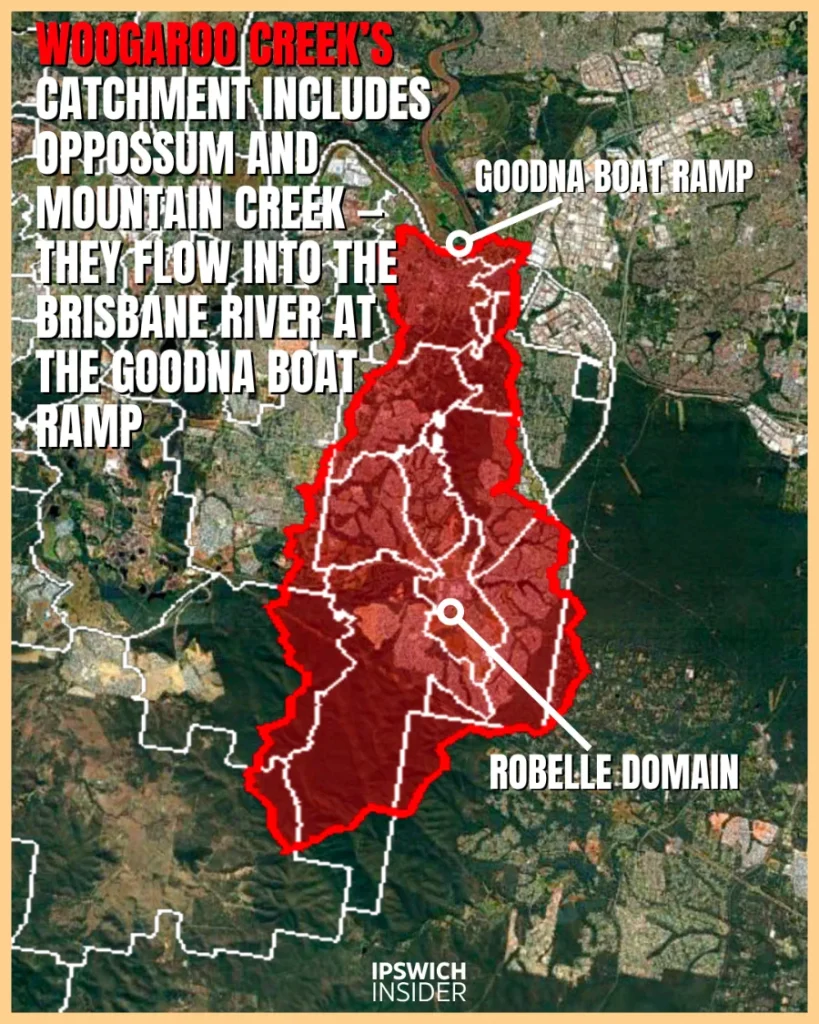
Woogaroo Creek (incl. Opossum & Mountain)
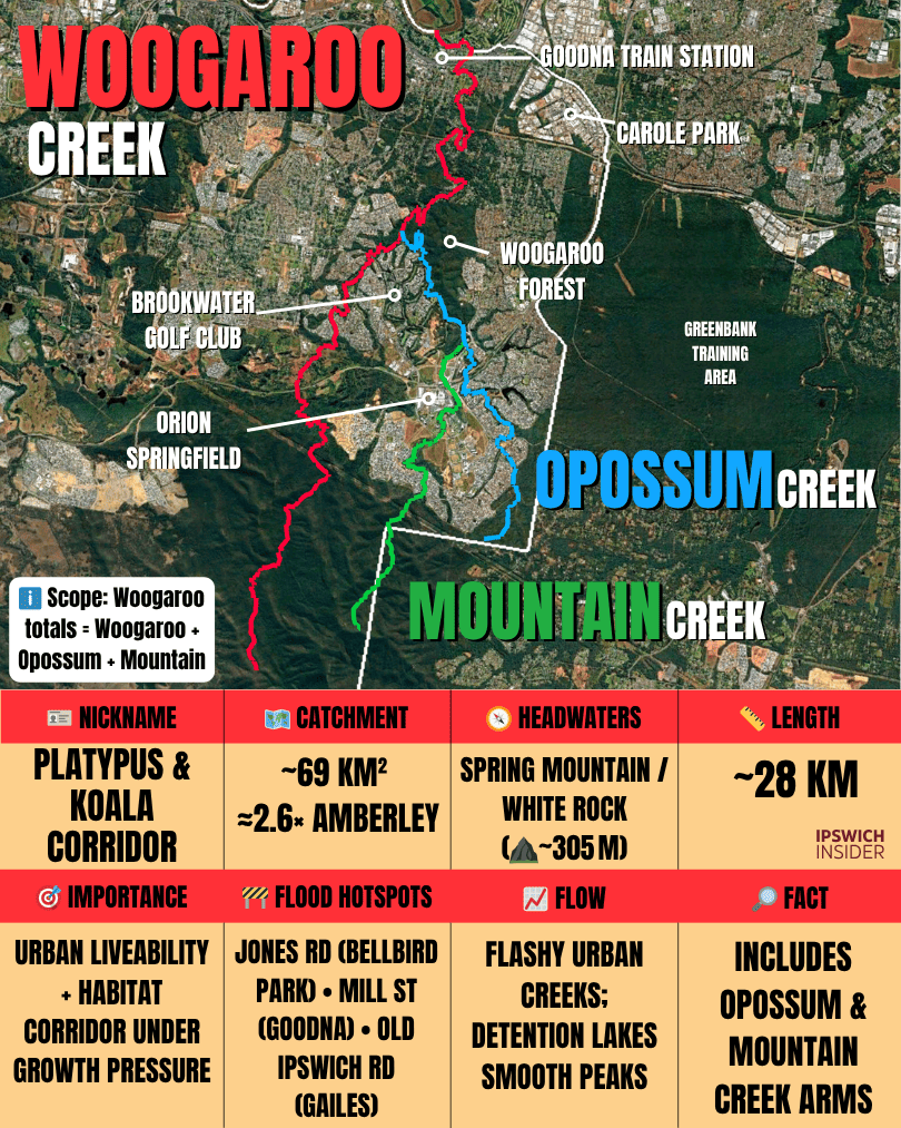
See Woogaroo Creek’s catchment:
≈69 km² (share of Bremer: 0%). Drains the Springfield–Brookwater–Augustine Heights corridor, taking Opossum Creek and Mountain Creek before meeting the Brisbane River at Goodna. Headwater lakes around Springfield help moderate peaks compared with similarly sized urban creeks.
🎯 Role and identity
Main use or benefit
- Urban liveability: A green‑blue spine through Springfield and Goodna providing shade, habitat, floodways and a link from White Rock bushland to the Brisbane River.
Nickname
- Moniker: Platypus & Koalas Corridor — repeated urban‑edge records make this a community favourite.
🧭 Physical setting
Where it starts
- Headwaters & LGA: White Rock–Spring Mountain Conservation Estate.
- Elevation at rise: High point ~305 m.
Length
- Main stem: Not formally published for the combined corridor. Several long arms meet near Goodna.
Catchment
- Area & setting: ~69 km², mostly within Ipswich, across Springfield Lakes, Springfield, Brookwater, Bellbird Park, Camira and Goodna.
Flow and volume
- Regime: Flashy urban creeks. Detention lakes and wetlands in the middle sections smooth peaks and trap sediment.
🌊 Water and wildlife
Health snapshot
- Condition: Lower Brisbane context trends poor though headwater protection inside White Rock helps. Shade and roots matter here.
Animals & protected areas
- Wildlife: Multiple platypus sightings since 2021 and strong koala records in Goodna and Springfield belts.
Conservation & development
- Status: “Woogaroo Forest” is a local name for remnant bushland between Springfield, Brookwater, Bellbird Park, Camira and Goodna. It is not a gazetted reserve and it supports koalas, greater gliders and 100+ bird species.
- Current proposals: The Springview precinct plan and other staged proposals would clear parts of this bushland for roughly 1,000–1,800 homes. Federal EPBC review activity is noted.
- Community & planning: The area sits inside long‑standing Springfield growth plans from the late 1990s. Community and conservation groups campaign for protection and corridor retention.
- Balance note: Council cites historic zoning. The developer argues habitat significance is contested. Opponents point to frequent koala records and corridor value.
Flooding
- Hotspots: Bellbird Park and Camira see short‑lag storm peaks. Goodna’s lower channels can overtop under back‑to‑back cells.
🏘️ People and places
Suburbs drained
- Start to finish: Spring Mountain/Springfield Lakes → Springfield/Brookwater → Goodna/Gailes.
People & housing
- Settlement: Fast‑growth suburbs with many riparian reserves and lakes that double as parks.
Major crossings & infrastructure
- Crossings & works: Centenary Hwy spans the corridor. The Springfield Lakes detention network throttles flows and creates loop walks.
Access & boat ramps
- Launch: Use Goodna Boat Ramp on the Brisbane River. Woogaroo Forest
Walking, swimming & fishing
- Spots: Best for walking and birding around Woogaroo forest/Opossum Creek Dog Park, Ric Nattrass Environmental Park, Robelle Domain. Fishing and paddling are better on the river.
🕰️ Stories and history
Settlement & industry history
- Institutional past: The historic Woogaroo hospital complex sits near the creek mouth and gave the district its early European name.
🔎 Woogaroo Creek (incl. Opossum & Mountain) cool facts box
- 1️⃣ Cool: Community science keeps adding platypus records and helps fund more riparian planting.
- 2️⃣ History: “Woogaroo” once named the whole reach before “Goodna” took over on maps.
- 3️⃣ Infrastructure: New green bridges and boardwalks stitch trail networks across the corridor.
Goodna Creek
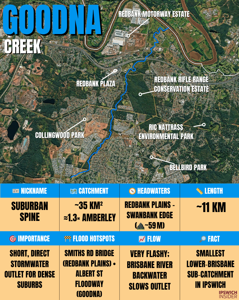
See Goodna Creek’s catchment:
≈15 km² (share of Bremer: 0%). Drains Redbank Plains–Collingwood Park–Goodna to the Brisbane River at Redbank-Goodna border beside Redbank Motorway Estate. A small, urbanised basin with short flow paths, so storms tend to produce a fast time-to-peak.

🎯 Role and identity
Main use or benefit
- Stormwater artery: Moves runoff from Redbank Plains and Collingwood Park into the river at Goodna while providing pockets of urban habitat.
Nickname
- Moniker: Suburban Spine — short, direct and very busy in wet weather.
🧭 Physical setting
Where it starts
- Headwaters & LGA: Redbank Plains–Swanbank edge.
- Elevation at rise: ~59 m.
Length
- Main stem: Compact urban basin from ridge to river.
Catchment
- Area & setting: ~14 km², the smallest Lower Brisbane sub‑catchment in Ipswich, entering the river ~5 km downstream of Moggill Ferry.
Flow and volume
- Regime: Very flashy with rapid rises and drops during summer storms. Backwater can slow drainage at the mouth during big river floods.
🌊 Water and wildlife
Health snapshot
- Condition: Litter, hot runoff and channelisation reduce habitat. Shade and vegetated buffers deliver quick wins.
Animals & protected areas
- Wildlife: Water dragons, ibis and hardy fish in lower channels with corridor links to Woogaroo and the Brisbane.
Flooding
- Hotspots: Collingwood Park and Goodna floodways overtop quickly in heavy rain then empty fast once the cell passes.
🏘️ People and places
Suburbs drained
- Start to finish: Redbank Plains → Collingwood Park → Goodna → Brisbane River.
People & housing
- Settlement: Some of Ipswich’s most populated suburbs sit along this short catchment so stormwater timing matters.
Major crossings & infrastructure
- Crossings & drains: Local collector roads and culverts step across the channel through Goodna and Collingwood Park.
Access & boat ramps
- Launch: Goodna Boat Ramp on the Brisbane River and nearby riverside parks.
Swimming & fishing
- Spots: Treat the creek as a walking corridor. Save fishing for the main river.
🕰️ Stories and history
Settlement & industry history
- Suburban drain: 1970s–2000s subdivisions built out the corridor. New bikeways turn floodways into everyday greenways.
🔎 Goodna Creek cool facts box
- 1️⃣ Cool: Fresh bikeway links are stitching pocket parks into a continuous local ride beside the creek.
- 2️⃣ History: Early town life leaned on riverboat landings just downstream.
- 3️⃣ Infrastructure: Brisbane Terrace and Queen Street causeways still shape how floodwater spreads and returns.
Six Mile Creek

See Six Mile Creek’s catchment:
≈31 km² (share of Bremer: 0%). A Brisbane River tributary with compact headwaters and short flow paths make it a quick responder to summer storms, with bushland reaches helping take a little edge off the first flush.

🎯 Role and identity
Main use or benefit
- Green‑blue link: Connects White Rock Conservation Estate to the Brisbane River and helps buffer heat through bush and suburban edges.
Nickname
- Moniker: White Rock Run — a short sprint from protected ridges to the river.
🧭 Physical setting
Where it starts
- Headwaters & LGA: White Rock–Spring Mountain behind the new White Rock Estate.
- Elevation at rise: ~151 m.
Length
- Main stem: Compact corridor from Camira and Redbank Plains through Carole Park to the river at Redbank.
Catchment
- Area & setting: ~31 km² across Camira, Augustine Heights, Collingwood Park and Redbank with industry near the mouth.
Flow and volume
- Regime: Small and flashy with short‑lead storm peaks. Lower culverts move water off flats fast.
🌊 Water and wildlife
Health snapshot
- Condition: Lower‑reach channelisation and legacy voids add stress. Headwater bush offsets some impacts.
Animals & protected areas
- Wildlife: Platypus detections in neighbouring creeks suggest occasional use. Bush edges support birds and skinks near the industrial zone.
Flooding
- Hotspots: Camira and Carole Park local roads can close quickly under intense summer dumps.
🏘️ People and places
Suburbs drained
- Start to finish: Camira/Redbank Plains → Augustine Heights/Carole Park → Redbank → Brisbane River.
People & housing
- Settlement: Suburban streets in upper and middle reaches. Industry and logistics near the mouth.
Major crossings & infrastructure
- Crossings & works: Centenary Hwy and multiple culverts cross lower channels near the industrial estate.
Access & boat ramps
- Launch: Trails in White Rock for walking. Boating via Brisbane River ramps.
Swimming & fishing
- Spots: Not a swimming creek. Use river nodes for paddling and fishing.
🕰️ Stories and history
Settlement & industry history
- Industry fringe: Mid‑reaches run beside Carole Park industrial lands. Floodways double as service corridors and green buffers.
🔎 Six Mile Creek cool facts box
- 1️⃣ Cool: White Rock Conservation Park sits right on the edge of city growth so this little creek feels wild close to town.
- 2️⃣ History: Early quarry and mining areas around New Chum and Redbank relied on nearby creeks.
- 3️⃣ Infrastructure: Centenary Hwy and Ipswich Motorway feeders culvert the lower reaches and shape local flood behaviour.
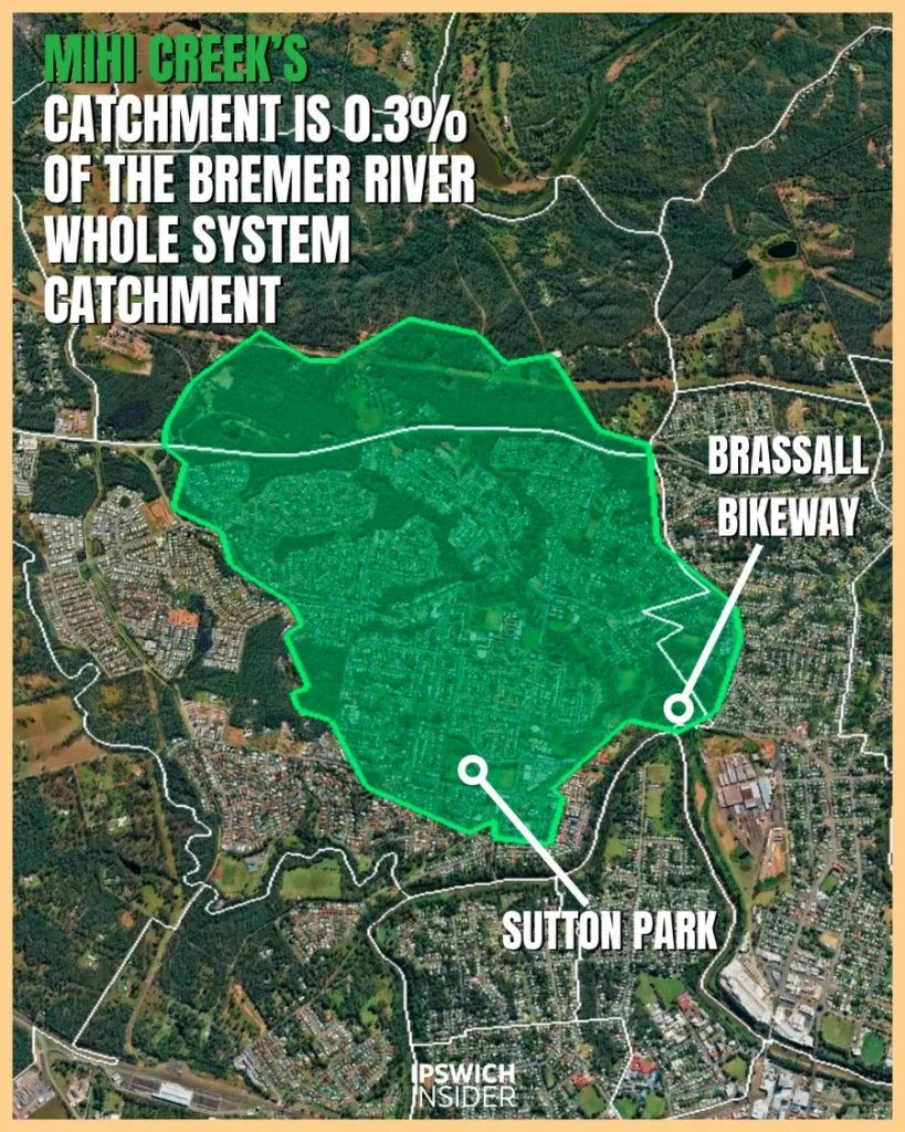
Mihi Creek

See Mihi Creek’s catchment:
≈6 km² (~0.3% of Bremer). A tiny, urban headwater draining North Ipswich–Tivoli to the Bremer River near Mihi Junction. Short, culverted flow paths make it one of Ipswich’s fastest responders, with sharp little peaks that fade quickly.
🎯 Role and identity
Main use or benefit
- Heritage greenway: A compact creek doubling as a linear recreation reserve and outdoor museum for industrial archaeology.
Nickname
- Moniker: Coke Ovens Creek — the beehive ovens and tramway remnants define its banks.
🧭 Physical setting
Where it starts
- Headwaters & LGA: Just north of Warrego Hwy at Muirlea.
- Elevation at rise: ~58 m.
Length
- Main stem: Tiny urban creek from ridge to the Bremer near Albion Street Bridge.
Catchment
- Area & setting: ~5.9 km² entirely within Ipswich and draining the ridge between the Brisbane and Bremer catchments.
Flow and volume
- Regime: Extremely flashy micro‑catchment that drains quickly after storms and leaves pools against rock shelves.
🌊 Water and wildlife
Health snapshot
- Condition: Urban edge with gains where weeds are removed and banks replanted. Erosion persists in northwest headwaters.
Animals & protected areas
- Wildlife: Water dragons and kingfishers are common. River adjacency adds occasional estuarine visitors on big tides.
Flooding
- Hotspots: Short‑lag peaks tumble into the Bremer’s flood‑prone bends with little notice during summer cells.
🏘️ People and places
Suburbs drained
- Start to finish: Brassall/Wulkuraka → North Ipswich near the Bremer junction.
People & housing
- Settlement: Urban banks with parks and rail heritage. Houses step back where the floodway widens.
Major crossings & infrastructure
- Crossings & heritage: Historic rail embankments and culverts line the corridor near Albion Street.
Access & boat ramps
- Launch: Park paths reach the ovens precinct. Boats launch on the Bremer at River Heart and nearby parks.
Swimming & fishing
- Spots: Not a swim creek. The riverside parklands downstream are the better play.
🕰️ Stories and history
Settlement & industry history
- Coke & rail: Beehive ovens from the 1880s–1900s and tramways supplied coke to local industry and the workshops.
🔎 Mihi Creek cool facts box
- 1️⃣ Cool: Brick domes hide in scrub and make a real‑life industrial time capsule.
- 2️⃣ History: Queensland’s first main line railway crossed this corridor and changed the town forever.
- 3️⃣ Infrastructure: Old embankments still nudge local hydraulics during minor flood rises.
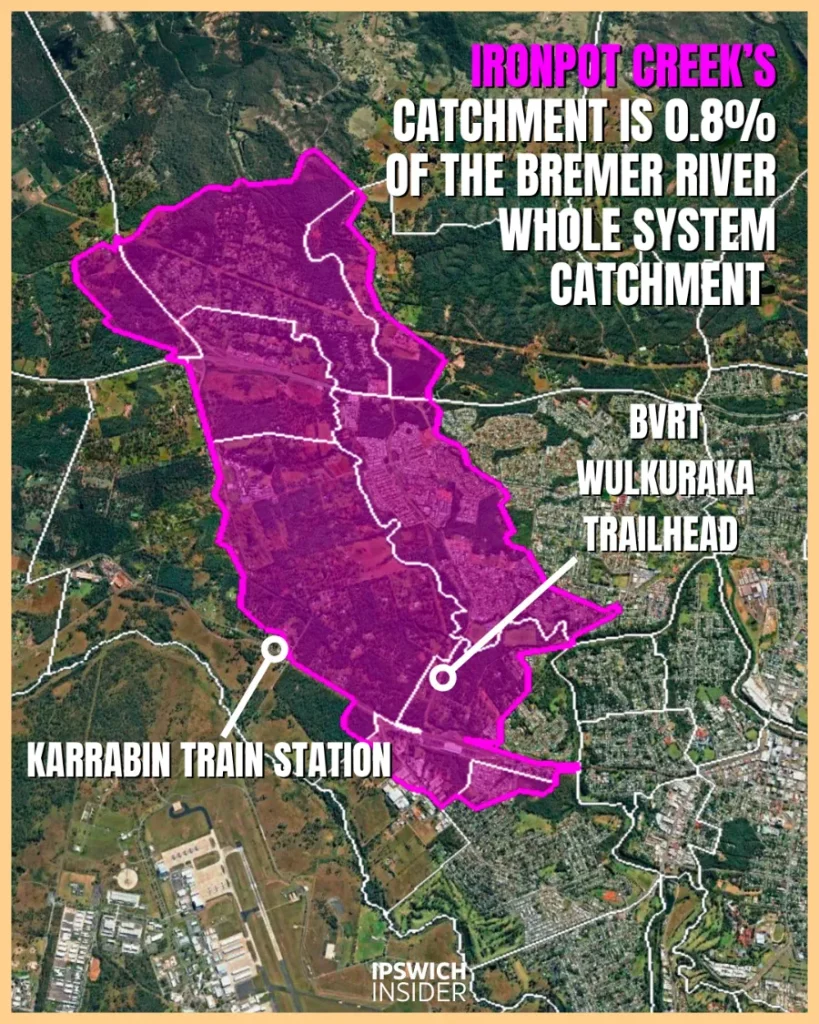
Ironpot Creek
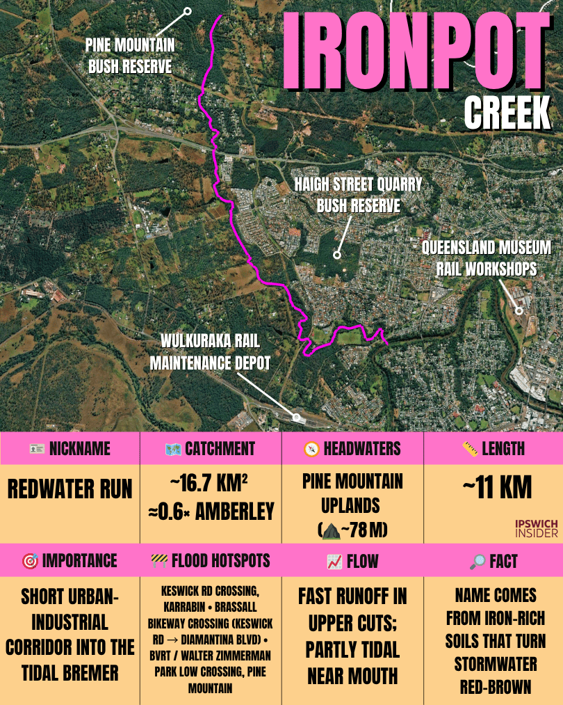
See Ironpot Creek’s catchment:
≈17 km² (~0.8% of Bremer). A small, suburban headwater draining Blacksoil–Brassall–Karrabin/Pine Mountain–Wulkuraka to the Bremer River just upstream of the Albion St bridge (Hancock Bridge). Short, culverted flow paths give it a quick time-to-peak, but total volumes are modest compared with the big rural creeks.
🎯 Role and identity
Main use or benefit
- Stormwater trunk: Carries runoff from corridors and estates into the Bremer estuary while linear parks add shade and paths.
Nickname
- Moniker: Quarry‑to‑River — passes old quarries and mines on the way to the tidal Bremer.
🧭 Physical setting
Where it starts
- Headwaters & LGA: Pine Mountain Bush Reserve.
- Elevation at rise: ~78 m.
Length
- Main stem: Small urban tributary from ridge to estuary flats.
Catchment
- Area & setting: ~16.7 km² across Pine Mountain, Brassall and Wulkuraka. Upper banks are incised and the lower channel is partly tidal.
Flow and volume
- Regime: Highly modified and fast to respond. Lower culverts move water off flats into the Bremer bend.
🌊 Water and wildlife
Health snapshot
- Condition: Urbanised with priority sites for bank stabilisation and revegetation. Estuarine reaches support hardy fish and invertebrates.
Animals & protected areas
- Wildlife: Ibis and egrets forage on the lower flats. Native fish move in and out with the tide in the last bends.
Flooding
- Hotspots: Bikeway and culvert low points in Brassall and Wulkuraka respond quickly to short downpours.
🏘️ People and places
Suburbs drained
- Start to finish: Pine Mountain → Brassall → Wulkuraka → Bremer estuary at North Ipswich/Tivoli.
People & housing
- Settlement: Industrial and logistics uses near the lower bends. Mixed residential up‑catchment.
Major crossings & infrastructure
- Crossings & works: Lower estuary culverts near the Warrego Hwy and ongoing erosion‑repairs on incised upper banks.
Access & boat ramps
- Launch: Use Bremer River parks and ramps such as River Heart and Cribb Park.
Swimming & fishing
- Spots: Fish the Bremer proper rather than the creek for better access and footing.
🕰️ Stories and history
Settlement & industry history
- Coal & clay: Mining and brickworks shaped drainage and left today’s pits and benches.
🔎 Ironpot Creek cool facts box
- 1️⃣ Cool: Iron‑rich soils give storm runoff a rusty tinge and likely the creek’s namesake.
- 2️⃣ History: Old rail spurs once served pits and works lining this valley.
- 3️⃣ Infrastructure: Recent Urban Rivers funding targets erosion hotspots along incised upper banks.
Sandy Creek (Tivoli)
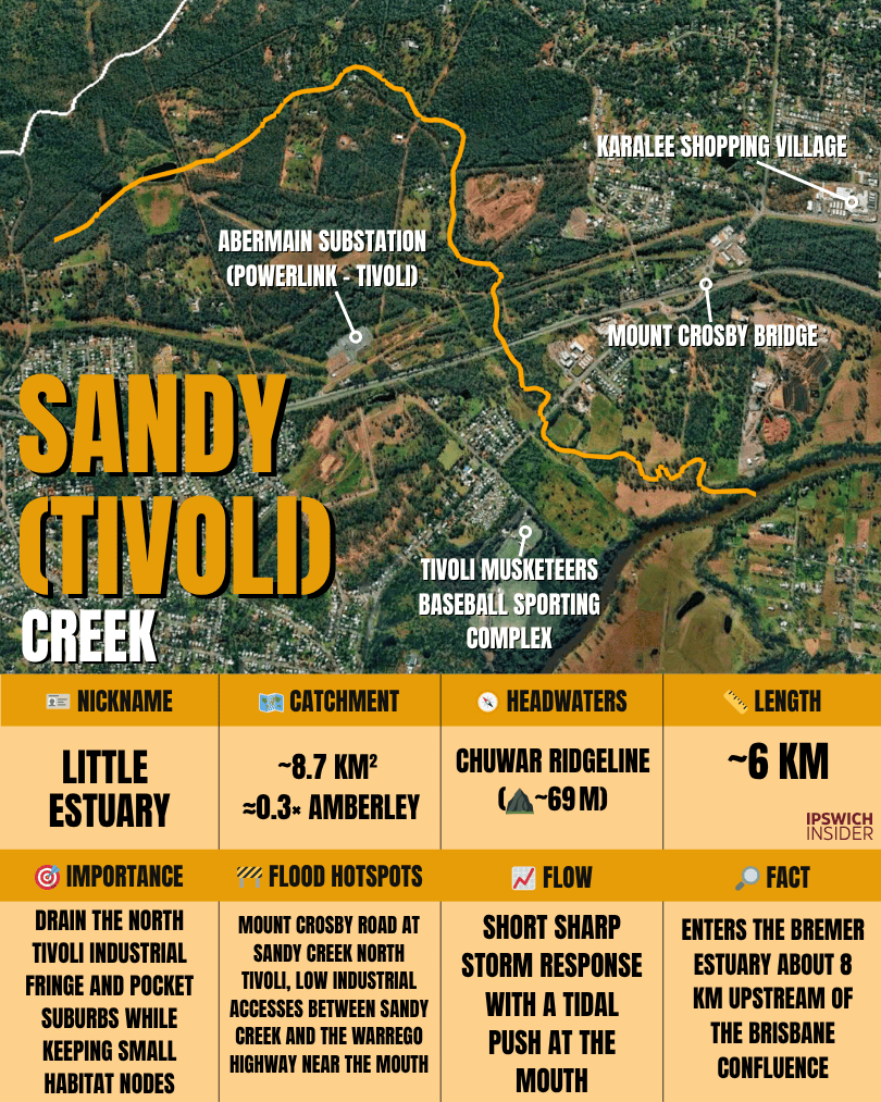
See Sandy Creek (Tivoli) catchment:
≈8.7 km² (~0.4% of Bremer). A small sub-catchment through Tivoli/North Tivoli (with headwaters in Chuwar), draining the ridge between the Brisbane and Bremer rivers before entering the Bremer River. Short flow paths make it a quick responder after storms. (Not to be confused with Sandy Creek at Camira on the Brisbane side.)

🎯 Role and identity
Main use or benefit
- Local liveability: Tiny catchment delivering shade, small habitat pockets and drainage for North Tivoli’s industrial fringe before meeting the tidal Bremer.
Nickname
- Moniker: Little Estuary — mangroves appear right at the mouth.
🧭 Physical setting
Where it starts
- Headwaters & LGA: Chuwar ridgeline in Ipswich.
- Elevation at rise: ~69 m.
Length
- Main stem: Pocket‑sized basin dropping to the Bremer in only a few kilometres.
Catchment
- Area & setting: ~8.7 km² through Chuwar to Tivoli and North Tivoli then the Bremer bend.
Flow and volume
- Regime: Short and sharp storm response with a tidal push at the mouth. Culvert size and blockages can noticeably alter local flooding.
🌊 Water and wildlife
Health snapshot
- Condition: Gains with weed control and buffer planting. The lower estuary brings fish and crabs into the last bends.
Animals & protected areas
- Wildlife: Mangroves and mudflats support foraging birds and small estuarine fish at high tide.
Flooding
- Hotspots: Low streets near the mouth respond in minutes to heavy downpours and spring tides.
🏘️ People and places
Suburbs drained
- Start to finish: Chuwar → Tivoli/North Tivoli → Bremer’s tidal reach.
People & housing
- Settlement: Industrial edges near the mouth with housing set back from the floodway and flats.
Major crossings & infrastructure
- Crossings & works: Warrego Hwy and local streets cross near the lower bends. Small culvert upgrades can reduce nuisance flooding.
Access & boat ramps
- Launch: Use Bremer River ramps and riverside parks.
Swimming & fishing
- Spots: Land‑based fishing at nearby parks on the Bremer confluence is popular when tides line up.
🕰️ Stories and history
Settlement & industry history
- Coalfields: The lower corridor flanks historic Tivoli works that left the flat landforms and spoil benches we still see.
🔎 Sandy Creek (Tivoli) cool facts box
- 1️⃣ Cool: Despite its size, the little estuary teems with life on a high tide.
- 2️⃣ History: Tivoli’s brickworks and quarries once lined the banks and shipped by river.
- 3️⃣ Infrastructure: A few small culvert changes can shift how stormwater behaves across whole blocks.
But wait, there’s more…
Safety note for anglers
- PFAS advisories: Check current Queensland Health guidance for parts of the Bremer, Warrill and Bundamba Creek before eating your catch. Catch‑and‑release is a safe default.
How these were ranked
- Method: Combined local impact score = catchment size and hydrologic influence + flood exposure to people and property + ecological and cultural significance + recreation or water‑supply role. We drew on Council’s catchment pages and regional flood studies for baselines.
Sources
- Waterways. ipswich.qld.gov.au
- Catchments and Plans. ipswich.qld.gov.au
- Franklin Vale Creek. ipswich.qld.gov.au
- Small Creek. ipswich.qld.gov.au
- Black Snake Creek Catchment. ipswich.qld.gov.au
- Healthy Land & Water Report Card. reportcard.hlw.org.au
- Catchment Summaries 2023. reportcard.hlw.org.au
- Mid Brisbane catchment story. wetlandinfo.des.qld.gov.au
- Brisbane River drainage sub‑basin. wetlandinfo.des.qld.gov.au
- Mt Crosby Water Treatment Plant fact sheet. seqwater.com.au